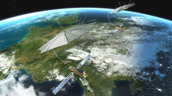
The objective of the TanDEM-X mission (TerraSAR-X add-on for Digital Elevation Measurement) is to produce a highly accurate, three-dimensional image of our Earth with uniform quality and unprecedented accuracy. For large parts of the earth, only rough, non-uniform or incomplete elevation models from different data sources and survey methods existed before the mission began. The previous maps therefore often have breaks, for example at national borders, or they are difficult to compare because they were created with different measurement methods and time-staggered measurement campaigns. TanDEM-X closes these gaps and provides a homogeneous elevation model as an indispensable basis for many commercial applications and scientific questions.
For this purpose, two almost identical satellites orbit the earth at an altitude of around 500 kilometres and scan the surface with radar equipment. The first of the two satellites, TerraSAR-X, has been operating successfully in space since 2007. Since 2010, it has been followed by the almost identical satellite TanDEM-X. Both fly only a few hundred metres apart in close formation, thus enabling the simultaneous imaging of the terrain from different angles. From this, precise elevation information is derived in a 12-metre grid and with a vertical accuracy of better than two metres.
The TanDEM-X Mission
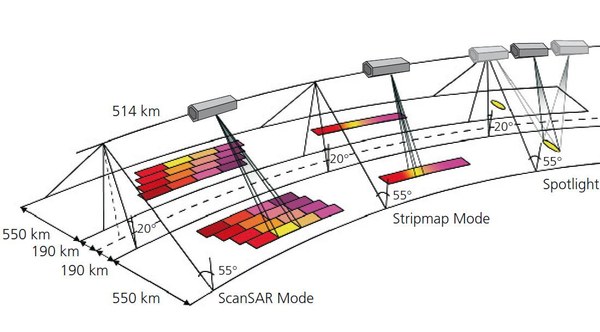
TanDEM-X and TerraSAR-X form the first configurable SAR interferometer (SAR = Synthetic Aperture Radar) in space. The TanDEM-X satellite is a replica of TerraSAR-X with minor extensions. It has an additional cold gas propulsion system and can therefore fine-tune its orbit for formation flight with TerraSAR-X. TanDEM-X also receives attitude and position data from its twin satellite. Since SAR systems actively 'illuminate' the earth's surface with its radar signals, measurements can be carried out around the clock, independent of daylight. In addition, SAR systems are largely independent of weather conditions, as the radar signals are able to penetrate clouds. Compared to optical sensors, images of the earth's surface can therefore be taken at any time. This contributes significantly to the reliability of the entire system, a feature that is increasingly demanded by many users.
In the period from 2011 to 2015, both satellites have surveyed the entire land surface of the Earth, i.e. 150 million square kilometres, several times completely in order to ensure the main objective of the mission, the creation of the global Digital Elevation Model (DEM). The global TanDEM-X terrain model has a grid size of 12 metres × 12 metres and has a high vertical accuracy, which is mostly better than 2 metres. Furthermore, it is homogeneous throughout and thus forms the basis for a globally uniform map material.
The production of the global terrain model from the acquired data set of both satellites was completed in September 2016. About 3 petabytes (equivalent to 3000 terabytes) of data were processed into the final digital 3D map product, which is now available in the form of 19,000 tiles. Each tile represents an area of 1° × 1° (longitude × latitude), corresponding to about 100 kilometres × 100 kilometres near the equator. The global TanDEM-X terrain model is also available in different product variants with a grid size of 12 metres, 30 metres and 90 metres.
The three-year acquisition phase for the global elevation model was followed by an acquisition phase to explicitly serve scientific needs such as forest mapping, snow and ice detection, observation of volcanoes, urban areas, ocean currents and the demonstration of new radar techniques to develop new applications.
If the earth's surface is analysed with the accuracy of TanDEM-X, it can be clearly seen that this is an extremely dynamic system. Not only altitude changes in glaciers, permafrost areas and forests, but also agricultural activities and changes in infrastructure leave clear traces in the digital terrain model. Therefore, since September 2017 a further complete survey of the Earth's landmass has been carried out in order to obtain another independent and unique data set. The resulting product, called 'Change DEM', will make it possible to track topographic changes worldwide.
A German key project
Following in the footsteps of European radar satellites ERS-1, ERS-2, Envisat and TerraSAR-X, as well as the joint US-German-Italian Spaceborne Imaging Radar-C/X-Band Synthetic Aperture Radar (SIR-C/X-SAR) that flew on the Space Shuttle and the US Shuttle Radar Topography Mission, TanDEM-X seeks to support scientific and commercial applications of radar-based Earth observation. Demonstrating Germany's expertise in satellite-based radar technology, the mission is the result of a long-term focus in Germany's national space programme.
Public-private partnership
TanDEM-X was launched on behalf of DLR as a public-private partnership (PPP) project with Airbus Defence and Space (formerly Astrium) with funding from the German Federal Ministry of Economic Affairs and Climate Action (BMWK). DLR is responsible for the scientific use of the TanDEM-X data, the planning and execution of the mission, the control of the two satellites and the generation of the digital elevation model.
Airbus Defence and Space built the satellite and contributes to the development and utilisation costs. As with TerraSAR-X, the 'Geo-Intelligence' programme line is responsible for the commercial marketing of the TanDEM-X data. Since 2016, the project has been continued under a continuation agreement with Airbus.
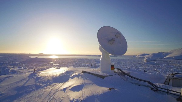
The mission involves the DLR Microwaves and Radar Institute, the DLR Remote Sensing Technology Institute and the DLR German Remote Sensing Data Centre, who jointly form the 'SAR Centre of Excellence'. The institutes complement each other by covering all relevant fields from sensor technology and mission design to high-precision operational processing and value-added end-user products. Together with DLR's German Space Operations Centre, they are also responsible for setting up the ground segment respectively the infrastructure for operating the satellites and processing the data. The DLR Microwaves and Radar Institute in Oberpfaffenhofen is responsible for scientific coordination.
News
Loading
Multimedia
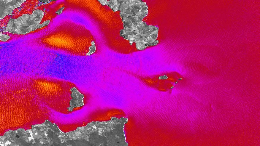
Currents in the Pentland Firth
Between the Scottish mainland and the Orkney island of South Ronaldsay, the water flows at very high speed. The German Aerospace Center (DLR) TerraSAR-X and TanDEM-X radar satellites make it possible to identify and analyse these currents from space.
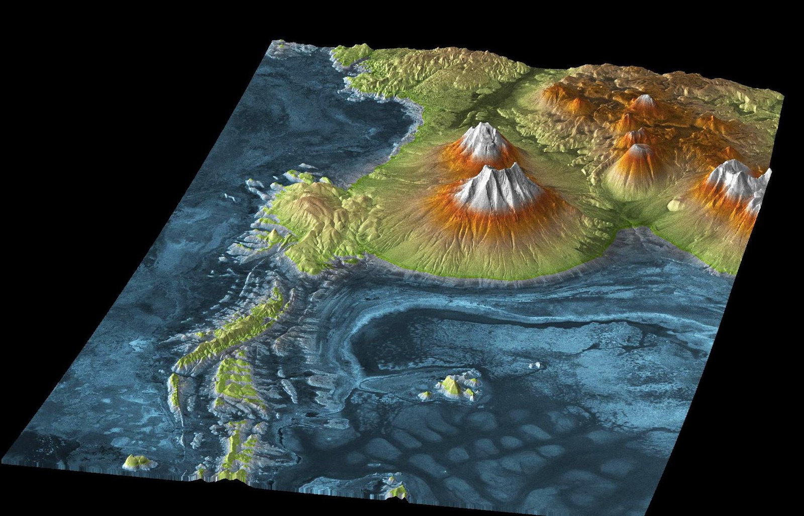
This TanDEM-X image shows Salar de Uyuni, the largest salt flats in the world covering 10,000 square kilometres, located next to the volcanic region of the Atacama Desert. The blue to dark blue areas show the lowest lying parts of the salt flats. A trained eye can see the boundaries of rock deposits in the three-dimensional model. This information about landscape features helps us draw important conclusions about the origins and development of the area.
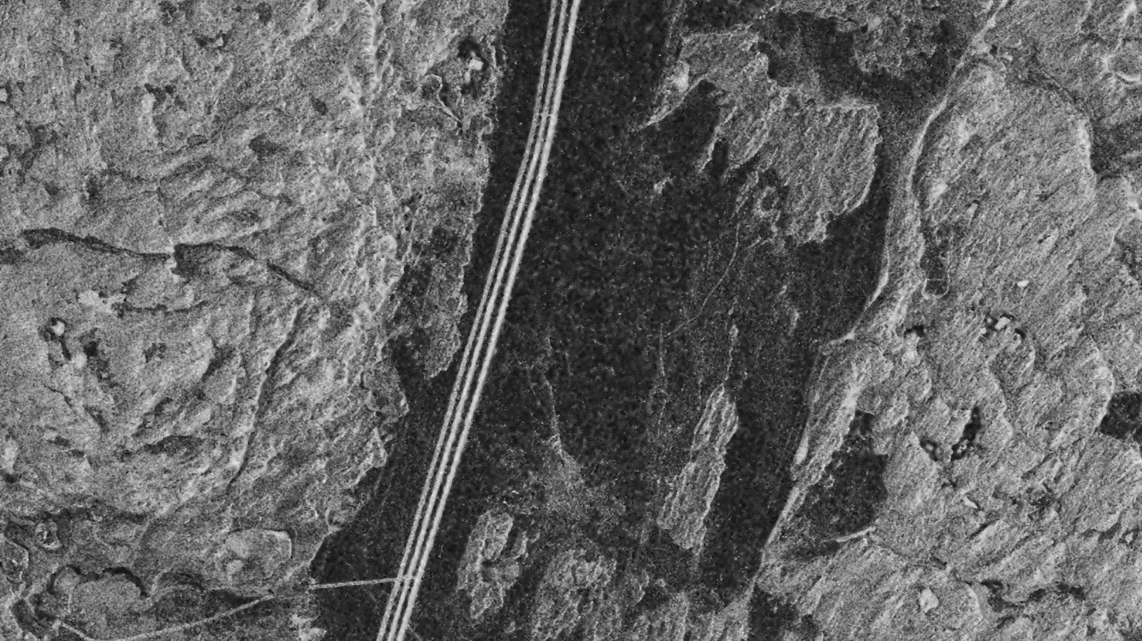
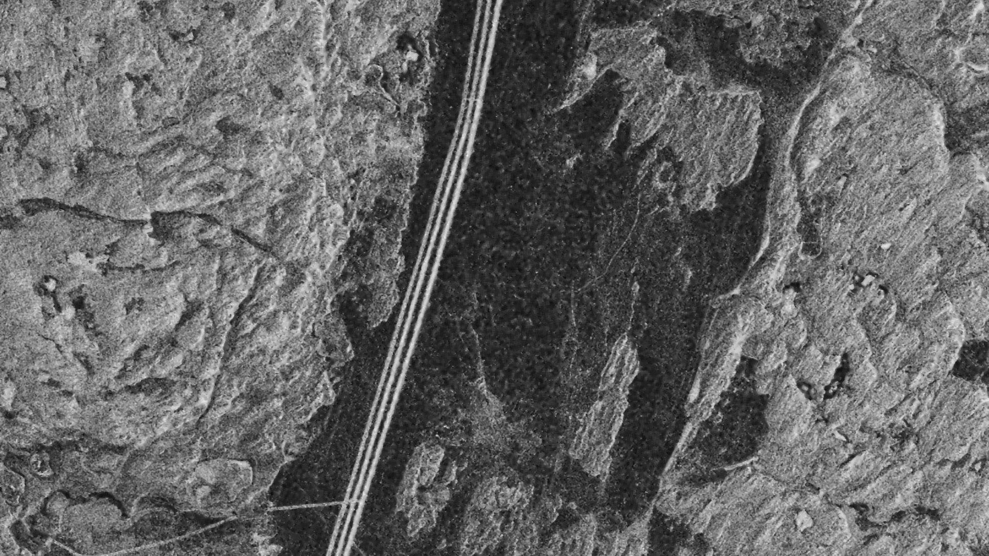
The TanDEM-X radar intensity map clearly shows the three lanes created by the Ice Road Trucks. The reason for this is the increased surface roughness of the three lanes. It makes them appear brighter than their surroundings. North is at the top of the image.

