Das System Erde im Blick – Satelliten zur Erdfernerkundung
Das System Erde im Blick – Satelliten zur Erdfernerkundung
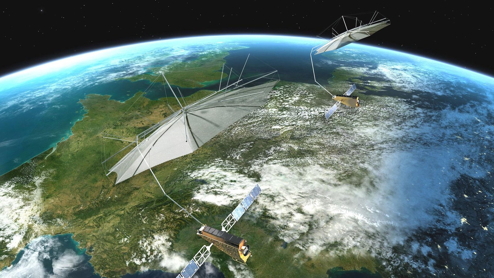
Mission Tandem-L
Tandem-L ist ein Vorschlag des DLR für eine hochinnovative Satellitenmission zur globalen Beobachtung von dynamischen Prozessen auf der Erdoberfläche in einer bisher nicht erreichten Qualität und Auflösung. Aufgrund seiner neuartigen Abbildungstechniken und seiner enormen Aufnahmekapazität kann Tandem-L dringend benötigte Informationen zur Lösung hochaktueller wissenschaftlicher Fragestellungen aus den Bereichen der Bio-, Geo-, Kryo- und Hydrosphäre liefern. Tandem-L würde damit entscheidend zu einem besseren Verständnis des Systems Erde und seiner Dynamik beitragen.
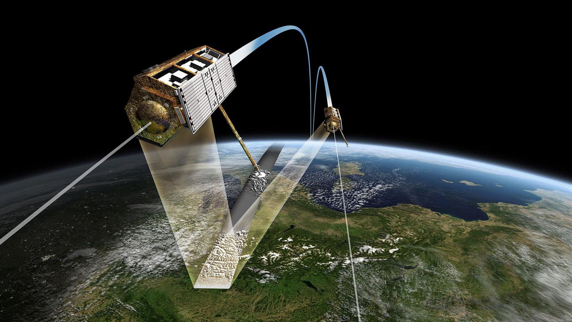
Die Satellitenzwillinge TerraSAR-X und TanDEM-X fliegen im engen Formationsflug mit nur einigen hundert Metern Abstand und erfassen so Daten für digitale Höhenmodelle.
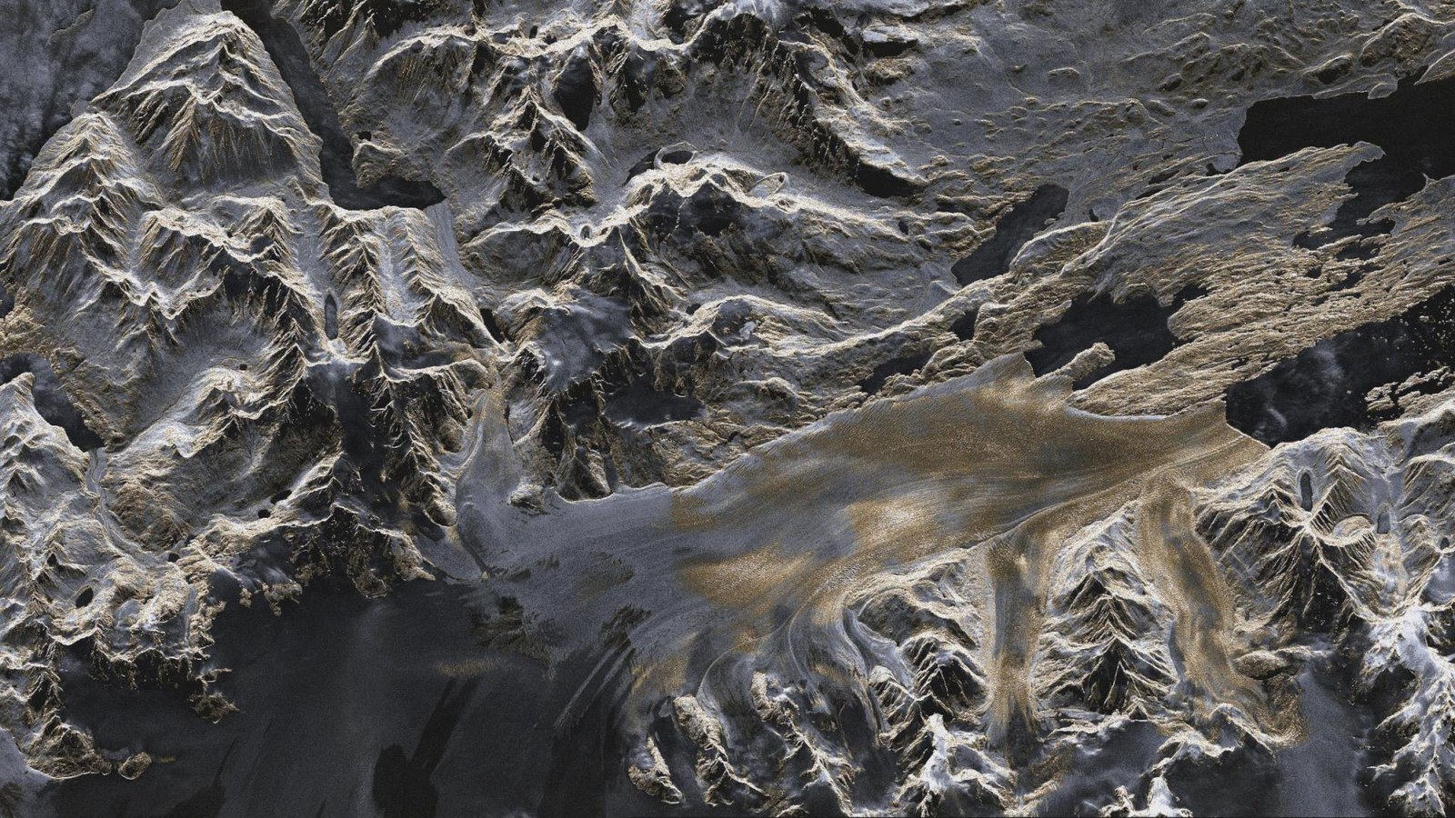
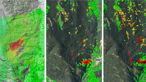
TerraSAR-X Aufnahme: Upsala-Gletscher in Patagonien
Künstlich eingefärbtes TerraSAR-X Bild (Stripmode) des Upsala-Gletschers in Patagonien/Argentinien vom 7. Januar 2008. Die Farben geben Auskunft über die Rauigkeit der Geländeoberfläche, Gebiete die vornehmlich glatt für das Radar erscheinen sind in dunkleren Grau- und Blautönen eingefärbt. Bereiche mit einer gröberen Oberflächenstruktur erscheinen dagegen in Gelbtönen.
Wie verändert sich unsere Erde? Welche Prozesse laufen auf ihr ab? Satellitengetragene Instrumente ermöglichen es, Informationen darüber umfassend zu erheben. Sie können sowohl globale Bestandsaufnahmen leisten, als auch präzise punktuelle Messungen vornehmen. Und durch lange Zeitreihen gestatten sie auch einen Rückblick in die Vergangenheit, um bessere Vorhersagen zu treffen. Mit ihnen können die Veränderungen unseres Heimatplaneten und damit auch die Ursachen und Folgen des Klimawandels auf einzigartige Weise erfasst und dokumentiert werden. Diese Daten bilden eine essentielle Grundlage für die Entwicklung von Maßnahmen auf politischer und gesellschaftlicher Ebene.
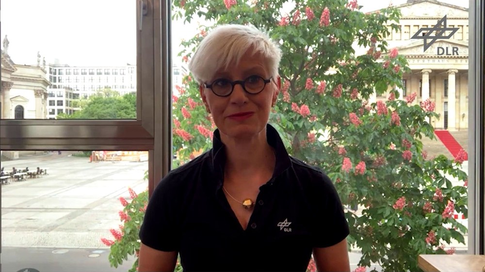
Satelliten sind unverzichtbar zur Bewältigung des Klimawandels. Sie liefern unabhängige Daten über den Zustand des Erdsystems. Sie sind ebenso unverzichtbar, wenn es darum geht, die Wirksamkeit und die Einhaltung von Klimaschutzmaßnahmen zu verifizieren. Im Video beschreibt DLR-Vorstandsvorsitzende Prof. Dr.-Ing. Anke Kaysser-Pyzalla, was die deutschen Erdbeobachtungsmissionen TanDEM-X und EnMAP leisten, um Lösungen zu finden und was eine zukünftige Radarmission Tandem-L darüber hinaus leisten kann, um die dynamischen Prozesse auf der Erdoberfläche besser zu verstehen. Denn nur, wenn man diese komplexen Wechselwirkungen kennt, lassen sich passgenaue Maßnahmen ergreifen.
Video: Prof. Dr.-Ing. Anke Kaysser-Pyzalla, DLR-Vorstandsvorsitzende, über den Nutzen der deutschen Missionen zur Erdfernerkundung
Für die Wiedergabe dieses Videos auf Quickchannel.com ist Ihre Zustimmung zur Speicherung von Daten ('Cookies') erforderlich. Unter Datenschutz-Einstellungen können Sie Ihre Wahl einsehen und verändern.
Video: Prof. Dr.-Ing. Anke Kaysser-Pyzalla, DLR-Vorstandsvorsitzende, über den Nutzen der deutschen Missionen zur Erdfernerkundung
Satelliten sind unverzichtbar zur Bewältigung des Klimawandels. Sie liefern unabhängige Daten über den Zustand des Erdsystems. Sie sind ebenso unverzichtbar, wenn es darum geht, die Wirksamkeit und die Einhaltung von Klimaschutzmaßnahmen zu verifizieren. Im Video beschreibt DLR-Vorstandsvorsitzende Prof. Dr.-Ing. Anke Kaysser-Pyzalla, was die deutschen Erdbeobachtungsmissionen TanDEM-X und EnMAP leisten, um Lösungen zu finden und was eine zukünftige Radarmission Tandem-L darüber hinaus leisten kann, um die dynamischen Prozesse auf der Erdoberfläche besser zu verstehen. Denn nur, wenn man diese komplexen Wechselwirkungen kennt, lassen sich passgenaue Maßnahmen ergreifen.
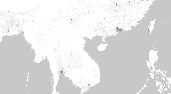
Satelliten zur Erdfernerkundung liefern zum Beispiel wichtige Informationen über den Anstieg des Meeresspiegels, den Zustand der globalen Eismassen, wie beispielsweise des Grönländischen Eisschilds, die Zunahme von Treibhausgasen in der Atmosphäre und Veränderungen in der Vegetation. Außerdem sammeln sie Daten über die weltweite Entwaldung und damit die Schädigung der Waldökosysteme. Die aktuelle Untersuchung der brasilianischen Weltraumbehörde INPE zur Rekordmenge der Abholzung des Amazonaswaldes mittels Satellitendaten ist ein aktuelles Beispiel dafür, wie wichtig diese Daten sind. Die weltweit einheitliche Erfassung des aktuellen Zustands der Wälder und deren – anthropogen wie auch klimatisch bedingter – Entwicklungsdynamik wird somit zu einer dringlichen Notwendigkeit.
Prof. Stefan Dech, Direktor des Deutschen Fernerkundungsdatenzentrums (DFD) des DLR, erläutert: „Die satellitengestützte Erdbeobachtung ist ein unverzichtbares Werkzeug, um die Veränderungen des Planeten Erde lückenlos zu dokumentieren und frühzeitig zu erkennen, wo irreversible Schäden entstehen und politische Eingriffe notwendig sind. Erst das Ozonloch – für den Menschen sichtbar gemacht durch Satelliten – hat zu einem Umdenken geführt. Und die weltweite Staatengemeinschaft konnte sich auf einheitliche Regelungen verständigen, um den Ausstoß von FCKW zu stoppen. Die Eindämmung des ungebremst stattfindenden globalen Wandels der Erde mit Umweltzerstörung, Verlust an Arten und dem Klimawandel, hervorgerufen durch die zunehmende Weltbevölkerung und den wachsenden Bedarf der Menschheit an Ressourcen für Nahrung, Energie und Wohlstand ist zu der Menschheitsaufgabe unserer Zeit geworden. Unsere Satelliten und deren Daten liefern die neutralen und unbestechlichen Fakten zum Status Quo. Sie zeigen, wo gehandelt werden muss und wo politische Maßnahmen bereits Wirkung zeigen. Mit modernsten DLR-Technologien zur wolkenunabhängigen Erdbeobachtung mit Radarsatelliten wie TerraSAR-X und TanDEM-X trägt das DLR entscheidend dazu bei, die Faktenlage und das wissenschaftliche Verständnis vieler Prozesse des Klimawandels zu verbessern. Zukünftige nationale Radartechnologien werden unter anderem die Bestimmung der Biomasse und damit des gebundenen Kohlenstoffs auf den Landoberflächen deutlich verbessern. Damit sind wir in der Lage, politische Entscheidungen noch belastbarer zu treffen und deren öffentliche Akzeptanz zu stärken.“
Insbesondere Radarsatelliten mit einem langwelligen Frequenzbereich (L-Band) können auch durch Vegetation hindurch bis zum Boden blicken. In den Polregionen könnte eine Radarmission im L-Band Gletscherstrukturen und dynamische Prozesse wie das Abschmelzen noch genauer abbilden. Deutschland könnte hier weiter neue Maßstäbe in der Erdfernerkundung setzen, den globalen Wandel mit einer neuen Qualität beobachten und wichtige Handlungsempfehlungen ermöglichen. Das Deutsche Zentrum für Luft- und Raumfahrt (DLR) hat dazu die Satellitenmission Tandem-L vorgeschlagen.
Prof. Alberto Moreira, Direktor des DLR-Instituts für Hochfrequenztechnik und Radarsysteme, betont: „Der Klimawandel stellt eine der größten Herausforderungen für die Menschheit in diesem Jahrhundert dar und hat unabsehbare Folgen. Auf der Weltklimakonferenz in Paris haben sich alle Staaten zu ambitionierten Maßnahmen verpflichtet. Das deutsche Klimaschutzgesetz und der Green Deal der Europäischen Kommission zielen auf eine konkrete Umsetzung und Treibhausgasneutralität bis spätestens 2050. Das Klimamonitoring – und damit auch die Überprüfung, ob die politischen Maßnahmen greifen – ist eine globale Aufgabe, die nur mit Satellitenbeobachtungen zu bewältigen ist. Radarsatelliten nehmen dabei eine besondere Rolle ein, denn nur sie ermöglichen eine globale, räumlich hochauflösende und großflächige Abbildung der Erdoberfläche unabhängig von Wetterbedingung und Tageslicht. Keine andere Sensortechnologie im Weltall hat diese Fähigkeit. Somit sind Radarsatelliten prädestiniert, Geoinformationen schnell, präzise, global und zuverlässig zu liefern. Seit mehreren Jahren arbeiten wir an der nächsten Generation von Radarsatelliten für Klimaforschung und Umweltbeobachtung mit dem Ziel, dringend benötigte Informationen zur Lösung hochaktueller Fragestellungen zu liefern. In Zeiten intensiver wissenschaftlicher und öffentlicher Diskussionen über das Ausmaß und die Auswirkungen von Klimaveränderungen liefert eine solche Satellitenmission wichtige, bisher fehlende Informationen für verbesserte wissenschaftliche Prognosen zum Klimawandel und darauf basierende gesellschaftspolitische Handlungsempfehlungen. Die Erfolgsbilanz der Missionen TerraSAR-X und TanDEM-X dient als guter Richtwert dafür, was von einer künftigen nationalen Satellitenmission für Klima und Umwelt erwartet werden kann.“
Das DLR ist in der Erdfernerkundung – satelliten- sowie flugzeuggestützt – in großem Ausmaß aktiv: Mit den Instituten für Methodik der Fernerkundung, für Hochfrequenztechnik und Radarsysteme, für Physik der Atmosphäre, für Optische Sensorsysteme und dem Deutschen Fernerkundungsdatenzentrum werden nicht nur viele Forschungsthemen des Globalen Wandels abgedeckt, sondern vielmehr in der Wissenschaft führend vertreten. Seit vielen Jahren erforscht das DLR den globalen Wandel mit den unterschiedlichsten Missionen. Es entwickelt Archivierungs- und Prozessierungstechnologien, Algorithmen zur Ableitung relevanter Parameter aus EO-Daten und analysiert die Ergebnisse.


