
Pol-InSAR
The main objective of the Polarimetric SAR Interferometry (Pol-InSAR) group is the development, implementation and validation of innovative algorithms and methods for the inversion of bio- and geophysical parameters from Pol-InSAR data, acquired by means of repeat- or single-pass, mono- or bistatic, single- or multiple-baseline configurations. From the very beginning, the group was leading the evolution of physical understanding, the development of inversion techniques and the validation of Pol-InSAR applications working in close cooperation with international experts and institutions. Applications are in the estimation of vegetation structure parameters, soil and plant moisture, vertical ice and snow layer extend and structure, etc. Further research topics are the application of SAR polarimetry and bistatic SAR polarimetry. The development of inversion techniques and the validation of Pol-InSAR applications are supported by pioneering and trendsetting air- and spaceborne experiments. In this sense, the group comprises unique experience in the design, execution and evaluation of scientific air- and space-borne experiments in the framework of campaigns necessary for the validation of the developed methodology/procedures. It manages and contributes to a number of national and international science development studies and supports the science activities of ongoing and future missions such as TerraSAR-X, TanDEM-X and Tandem-L through active participation and/or the coordination of the science teams and activities.
Application areas
Key projects and activities:
TanDEM-X is the first bistatic SAR mission formed by adding a second almost identical spacecraft to TerraSAR-X and flying the two satellites in a closely controlled formation. Primary mission objective is the generation of a consistent global digital elevation model according to the HRTI-3 specifications. Beyond that, TanDEM-X provides a highly reconfigurable platform for the demonstration of new SAR techniques and applications. TanDEM-X acquired for the first time single-pass multi-baseline Pol-InSAR data sets enabling the development of forest, agriculture and ice structure mapping on regional and larger scales. The group coordinate the national and international science activities in the frame of a science corodiantion and is responsible for the design and evaluation of interferometric and polarimetric interferometric experiments and product generation.
The Helmholtz Alliance “Remote Sensing and Earth System Dynamics” (EDA), is a Helmholtz research alliance with more than 140 interdisciplinary scientists from eight Helmholtz Centres, eight universities, three non-university research institutes, a Federal Research Institute and two international organisations. The aim of the Helmholtz Alliance is the development of innovative global bio- and geophysical information products that can only be delivered by a new generation of remote sensing satellites, and their integration into environmental science models. The group was responsible for the scientific coordination of the alliance and made significant science contributions in the Hydro-, Bio- and Cryo-sphere alliance themes.
Tandem-L is a national proposal for a highly innovative spaceborne SAR mission for the global observation of dynamic processes on the earth’s surface. Important mission goals are the global measurement of forest structure its temporal variation, the systematic monitoring of deformations of the Earth's surface, the quantification of glacier motion and melting processes in the polar regions as well as the fine scale measurement of variations in the near-surface soil moisture. Beyond the primary mission objectives, Tandem-L represents a tremendous opportunity for the development of novel scientific applications and commercial services. The group is actively involved from the very beginning in the development of the mission proposal leading, coordinating and contributing to the science definition and supporting the mission concept definition. The Tandem-L science team comprises approx. 180 national and international members; the 9 HGF centers AWI, DLR, HZG, GEOMAR, GFZ, HMGU, FZJ, KIT and UFZ form the core of the Tandem-L science team.
The group is involved in several ESA supppoted projects ranging from the development of electromagnetic models for the derivation of forward models and inversion of these models for the derivation of bio-/geo-physical parameters, the definition of science requirements for new mission concepts development to the management and execution of airborne multi-parametric SAR experiments for application and demonstration of new and innovative imaging modes.


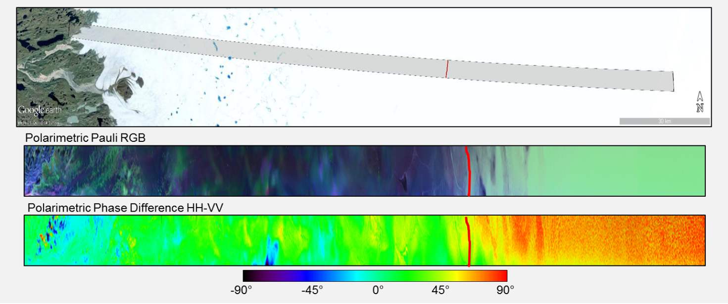
Figure 1: Quad-polarimetric transect, recorded in the L-band
Quad-polarimetric transect, recorded in the L-band during the ARCTIC15 campaign, with a length of 200 km, starting at the west coast of Greenland at an altitude of 300 m (left) to the inner part of the ice sheet at an altitude of 2100 m (right). The red line shows the equilibrium line at an altitude of about 1700 m, which separates the ablation zone from the accumulation zone (firn). The polarimetric Pauli-RGB composite image is shown in the center. The polarimetric HH-VV phase difference is shown at the bottom.