Tandem-L
A Satellite Mission for Monitoring Dynamic Processes on the Earth’s Surface
Tandem-L
Tandem-L is a proposal for a highly innovative satellite mission for the global observation of dynamic processes on the earth’s surface with hitherto unknown quality and resolution. Thanks to the novel imaging techniques and the vast recording capacity, Tandem-L will provide urgently needed information for solving pressing scientific questions in the areas of the biosphere, geosphere, cryosphere, and hydrosphere. Tandem-L will make a vital contribution towards a better understanding of the earth system and its dynamics.
Tandem-L is a proposal for a highly innovative satellite mission for the global observation of dynamic processes on the earth’s surface with hitherto unknown quality and resolution. Thanks to the novel imaging techniques and the vast recording capacity, Tandem-L will provide urgently needed information for solving pressing scientific questions in the areas of the biosphere, geosphere, cryosphere, and hydrosphere. Tandem-L will make a vital contribution towards a better understanding of the earth system and its dynamics.
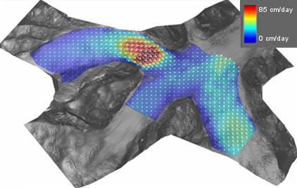
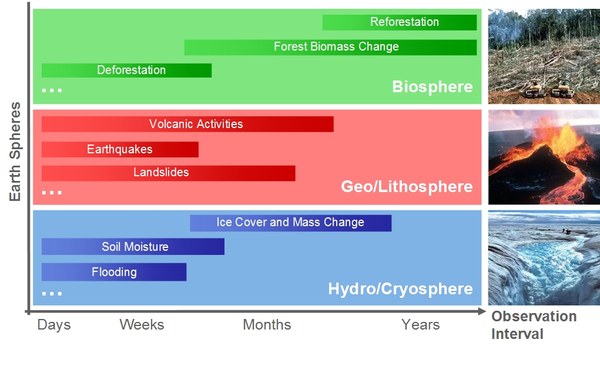
Important mission goals are the global measurement of forest biomass for a better understanding of the carbon cycle, the systematic recording of deformations of the earth’s surface with millimetre accuracy for earthquake research and risk analysis, the quantification of glacier movements and melting processes in the polar regions, the large scale observation of ocean currents and the high resolution measurement of variations in soil moisture close to the surface. Hence, in a time of intense scientific discussion about the extent and effects of climate change, Tandem-L can provide important, currently missing information for improved scientific forecasting and related socio-political recommendations.
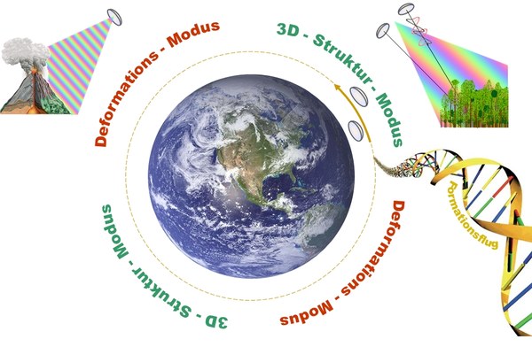
The Tandem-L mission concept is based on the use of two radar satellites operating in L-band (23.6 cm wavelength). The utilisation of the special synthetic aperture radar technique (SAR) enables high resolution imaging of the earth’s surface independent of weather and time of day; it therefore offers the ideal basis for the continuous observation of dynamic processes on the earth’s surface. Moreover, the long wavelength compared to X-band (3.1 cm) fulfills the requirements for a tomographic measurement of the three-dimensional structure of vegetation and ice regions, as well as for large scale surveying of deformations with millimetre accuracy. The goal of Tandem-L is to image the land mass interferometrically once a week. Above and beyond the primary mission goals, the data set generated by Tandem-L has immense potential for developing new scientific and commercial applications.
Beside the scientific component, Tandem-L is distinguished by the high degree of innovation with respect to the methodology and technology. Examples are the polarimetric SAR interferometry for measuring forest height, multi-pass coherence tomography for determining the vertical structure of vegetation and ice, the utilisation of the latest digital beam forming techniques for increasing the swath width and imaging resolution, as well as the close formation flying of two cooperative radar satellites with variable adjustable spacing.
The mission concept was developed in detail in a two-year pre-phase A study together with NASA/JPL. Tandem-L can be realized either via an international cooperation or on a plain national basis. The implementation of Tandem-L means a worldwide unique remote sensing system will be created, exceeding the performance of existing systems by at least an order of magnitude. According to current planning, the Tandem-L satellites could be launched in 2023.