Update: Disaster relief – DLR provides aerial images of Kathmandu
April 27, 2015
Update: Disaster relief – DLR provides aerial images of Kathmandu
DLR has calculated the displacements caused by the earthquake using satellite data
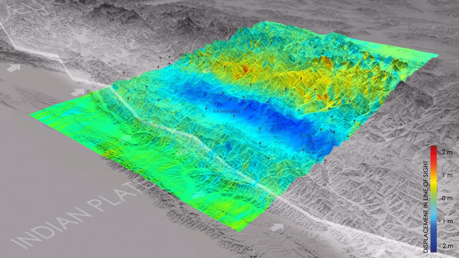
This image shows the changes in elevation and position that occurred in the direction of the satellite between data acquisitions before and after the earthquake. Tensions building up between the Indian and Eurasian tectonic plates were released by the earthquake and produced sudden ground movements. The resulting deformations are colour-coded. Near the plate boundary, the ground was moving towards the satellite, that is upwards (blue area); further to the north there was related subsidence (red and yellow), a counter-movement that often occurs during earthquakes in subduction zones. In addition, DLR researchers detected a strong horizontal movement of up to two metres in a north-south direction. In the image, the locations of numerous aftershocks in recent days are also displayed.
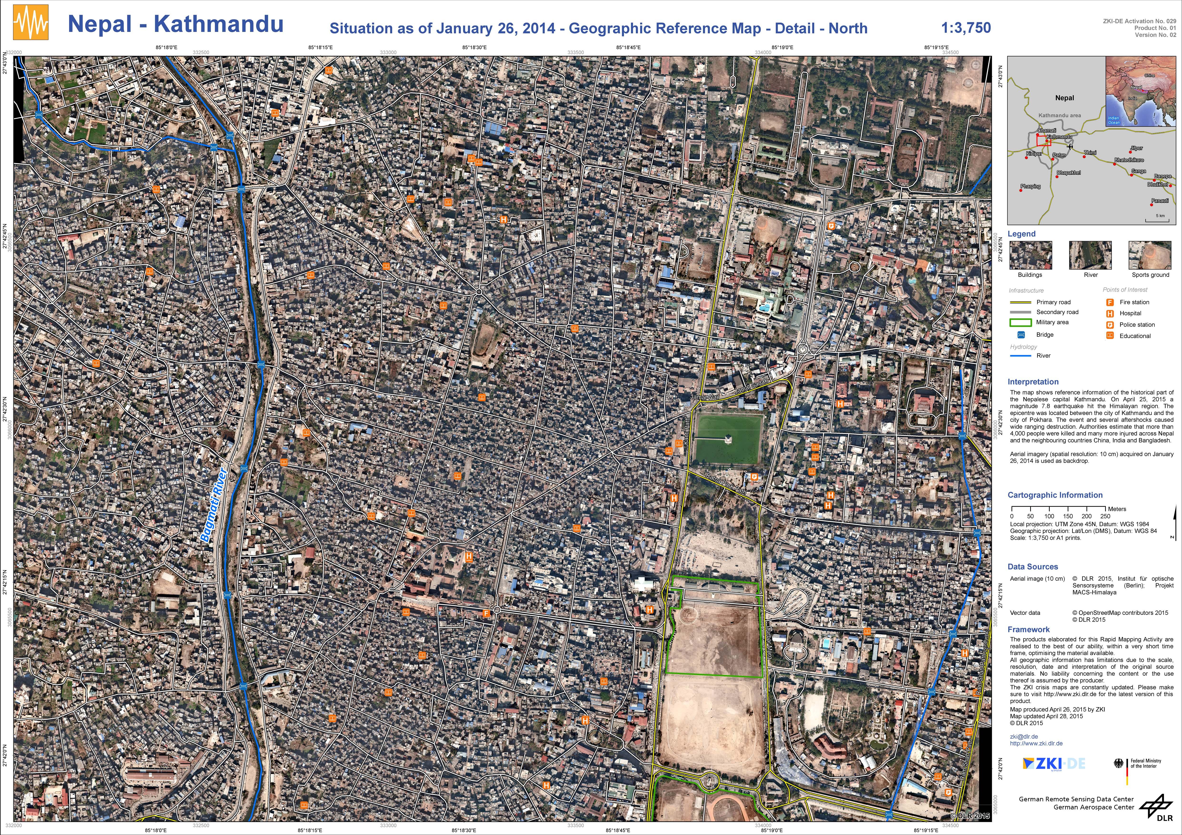
The image shows northern Kathmandu before the earthquake. The image has a resolution of 10 centimetres per pixel. It was acquired on 26 January 2014 using the MACS (Modular Airborne Camera System), and is being used by aid workers as a reference map. The entire file and legend is available by clicking on ‘Download’.
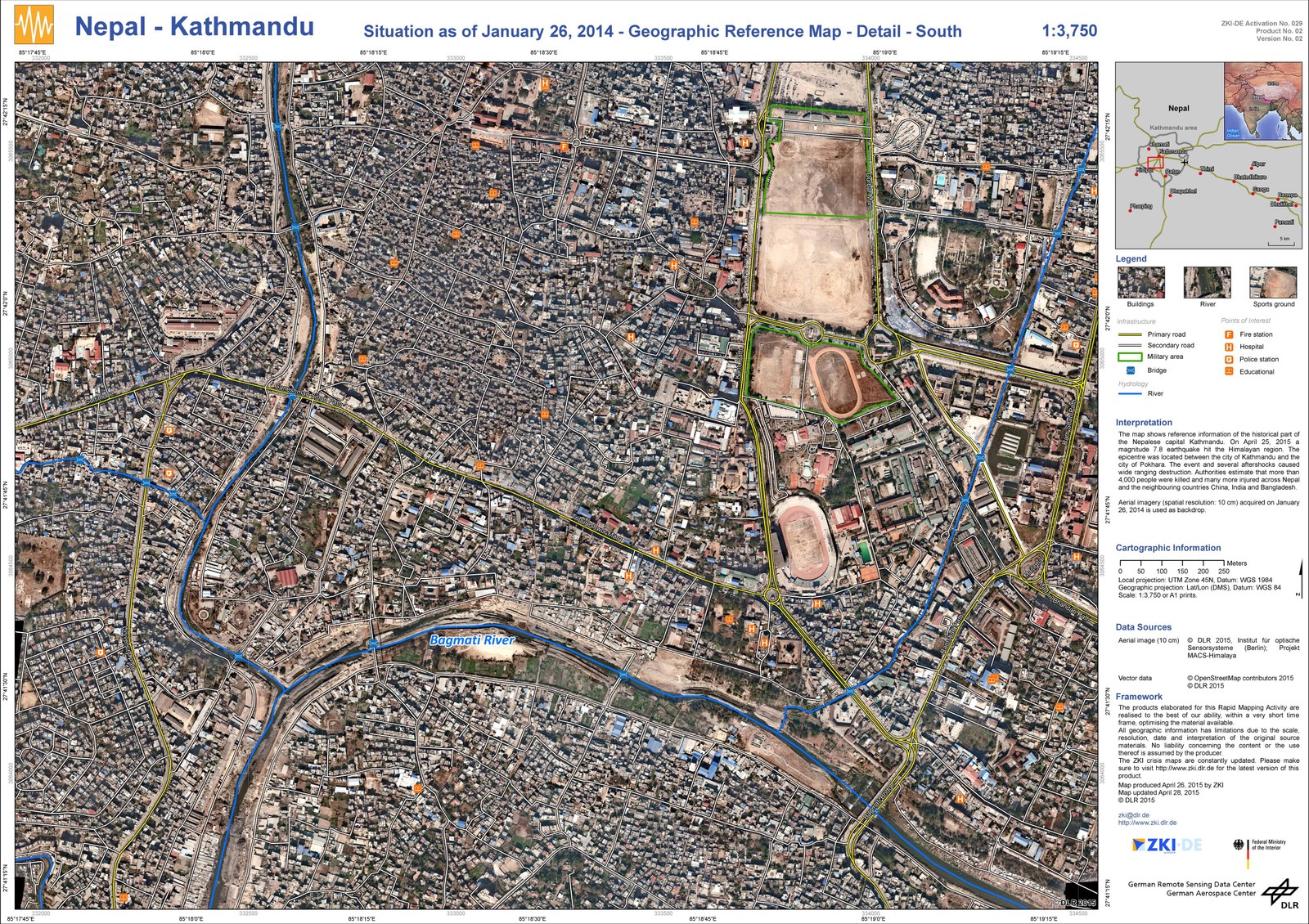
The image shows the southern part of historic Kathmandu. This image was also taken on 26 January 2014 as part of the Mountain Wave project and is now being used as a reference map for relief workers. The entire file and legend is available for ‘Download’.
Update – The German Aerospace Center (Deutsches Zentrum für Luft- und Raumfahrt; DLR) Earth Observation Center (EOC) has used data acquired by the ESA radar satellite Sentinel-1 over the earthquake region in Nepal to create a new regional aid map and calculate the ground displacements caused by the earthquake. The data were processed by the EOC to create an interferogram showing the surface displacements caused by the severe earthquake on 25 April 2015. A more than 90-kilometre-long and 30-kilometre-wide area around Kathmandu is affected. During the earthquake, tensions between the Indian and Eurasian plates were relieved and generated sudden ground movements of several metres. In the newly created map, the deformations are colour-coded; near the plate boundary, the surface moved towards the satellite, that is, upwards (blue area). Further to the north there was related subsidence (yellow), a counter-movement that often occurs during earthquakes in subduction zones. In addition, the researchers detected a strong horizontal movement of up to two metres in a north-south direction in the area. In the image, the locations of numerous aftershocks in recent days are also displayed. Scientists at the EOC are continuing to compare archival data of the area with the latest radar images from Sentinel-1.
The German Aerospace Center (Deutsches Zentrum für Luft- und Raumfahrt; DLR) Center for Satellite Based Crisis Information(Zentrum für satellitengestützte Kriseninformation; ZKI) is providing relief organisations in Nepal with reference maps of the Kathmandu region. These originate from high-resolution aerial image data from the DLR Institute of Optical Sensor Systems. In the meantime, the International Charter 'Space and Major Disasters' has provided satellite images to produce real-time overview images as quickly as possible, as well as enabling a damage assessment to be carried out.
The high-resolution data of Kathmandu was acquired in January 2014 and has now been forwarded by ZKI to the local relief agencies as reference maps. As a result, organisations such as the German Federal Agency for Technical Relief (THW) and the German Red Cross (DRK) have a site plan that shows the infrastructure prior to the earthquake. This enables, for example, the identification of access routes, landing places for helicopters and the determination of the main crisis areas. Such maps are also helpful for orientation in the field, as they give a very detailed view of the city prior to the earthquake. The images were aquired as part of the Mountain Wave Project, in which the DLR Institute of Optical Sensor Systems tested the MACS-Himalaya project homepage (MACS) in the Nepalese Himalayas and above the historic part of Kathmandu.
Background
On 25 April, an earthquake of magnitude 7.8 shook the Himalayas, the epicentre of which was located between the capital city of Kathmandu and Pokhara. The relief workers are already on site, but the provision of aid is proving to be complicated as a result of heavy damage to transport routes, power supplies and communication channels, as well as the continuous aftershocks. The full scale of the effect of the earthquake is not yet known. ZKI is continuing to work on processing additional map material that shows remote areas.
About the ZKI
The Center for Satellite Based Crisis Information (Zentrum für satellitengestützte Kriseninformation; ZKI) is a service operated by DLR German Remote Sensing Data Center (DFD). Its job is to provide a 24/7 service for quickly generating, processing and analysing satellite data in the event of natural and environmental disasters, for humanitarian relief services and for civil security across the world. The products are generated for national and international political decision-makers, situation rooms and aid organisations according to specific needs, and are also made freely available to the general public.
About the International Charter 'Space and Major Disasters'
The International Charter 'Space and Major Disasters' is an international association of space agencies that was established in 1999 by the European Space Agency (ESA) and the French space agency CNES. The association provides national emergency management agencies and relief organisations with data from Earth observation satellites quickly and bureaucracy-free assistance in the event of natural disasters or major technical failures.

