Changes in the Reventador volcano in the Ecuadorian Andes
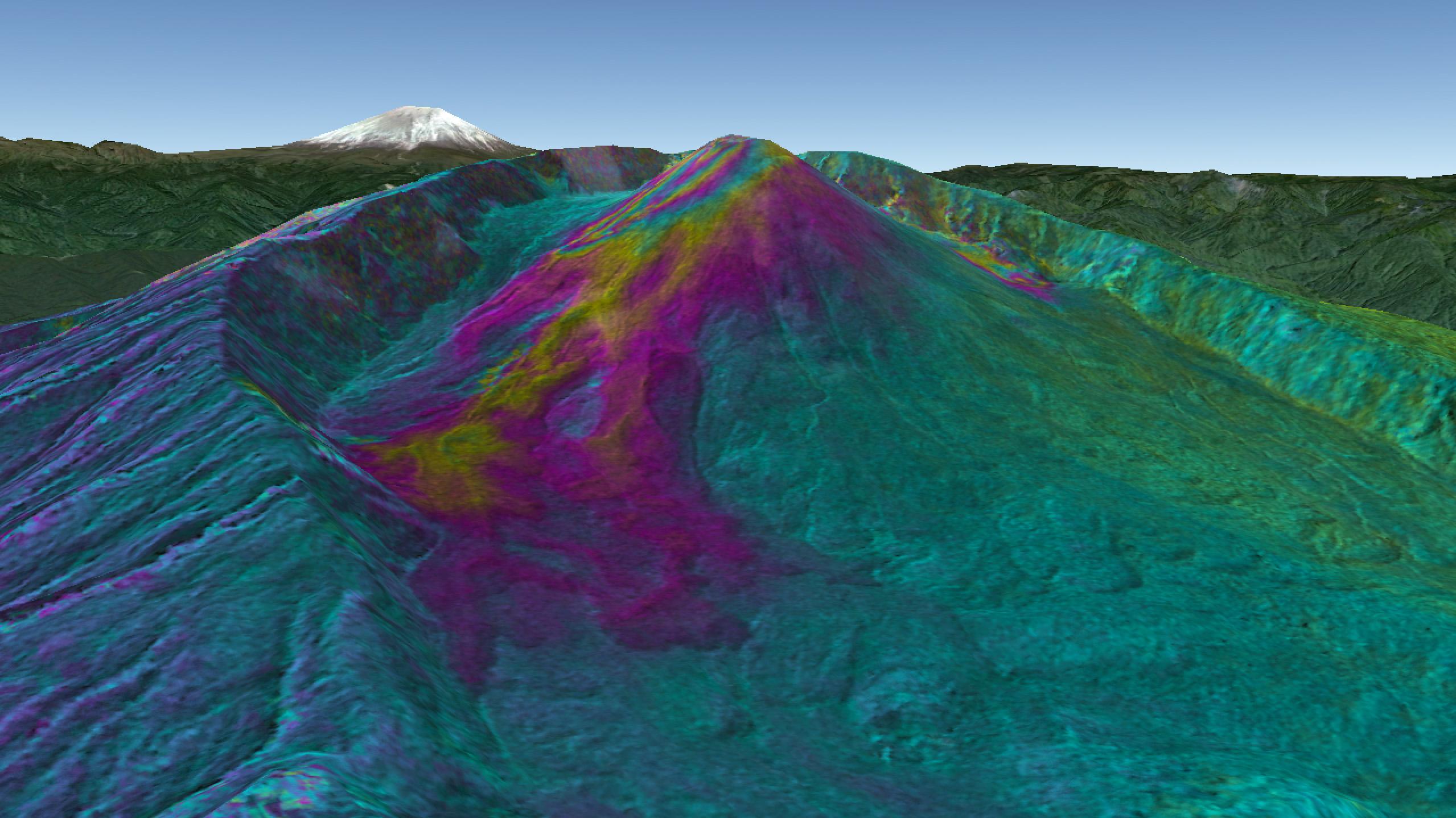
Three-dimensional representation of the analysis of the changes to the Reventador volcano in the Ecuadorian Andes since 2000, based on images acquired by the German satellites TerraSAR-X and TanDEM-X. The coloured areas show young lava fields and the growth of the volcano. A complete colour cycle corresponds to a 25-metre-thick layer of lava. There has been a rise of 75 metres at the peak of the volcano. The CEOS volcano project observes numerous active and currently dormant volcanoes in the Andes.
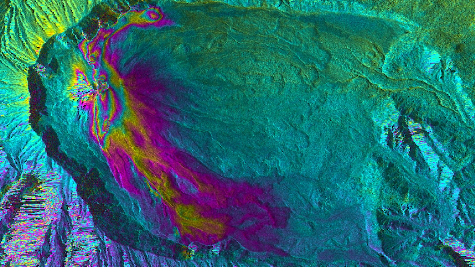
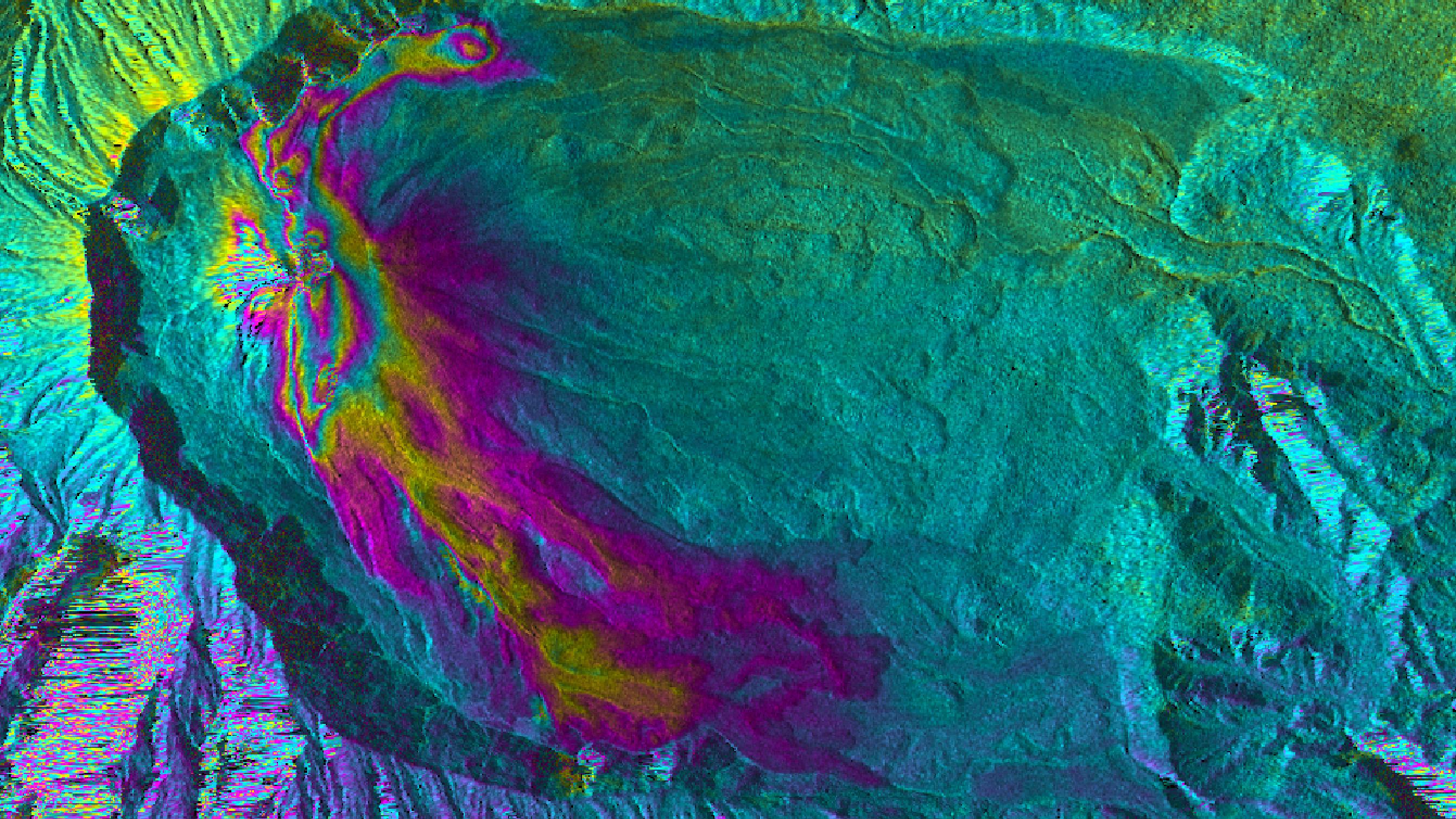
Analysis of the changes to the Reventador volcano in the Ecuadorian Andes since 2000, based on images acquired by the TerraSAR-X and TanDEM-X satellites. The coloured areas show young lava fields and the growth of the volcano. A complete colour cycle corresponds to a 25-metre-thick layer of lava. There has been an increase of 75 metres at the peak of the volcano. The CEOS volcano project observes numerous active and currently dormant volcanoes in the Andes.
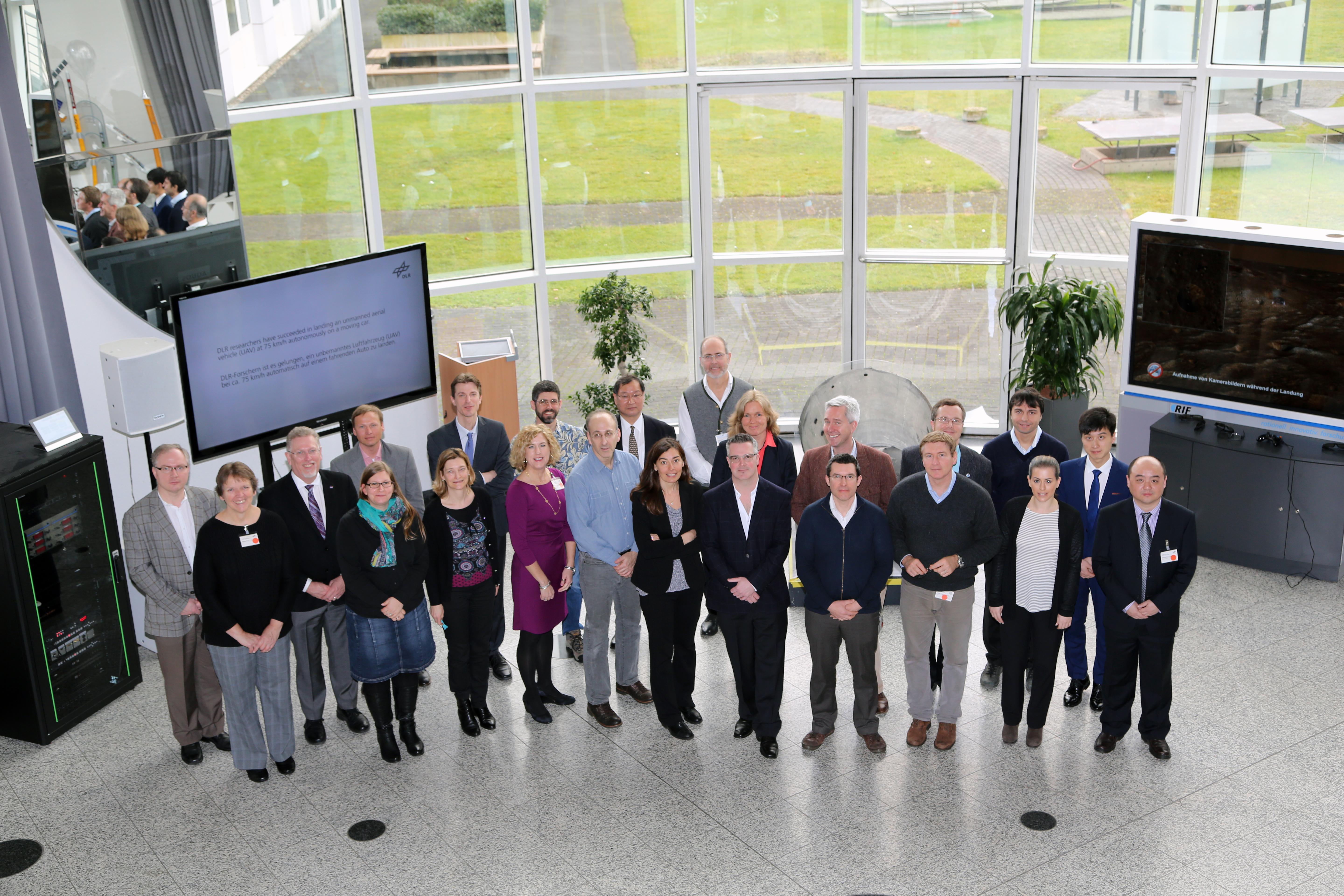
The members of the Working Group on Disasters of the international Committee on Earth Observation Satellites (CEOS) during their meeting at the DLR Space Administration in Bonn.
The earthquake that struck Haiti in 2010, the tsunami in Japan in 2011 that was triggered by an undersea earthquake, and the severe floods that, time and again, affect countries such as India and Bangladesh give rise to the question of how Earth observation satellites could help detect and study natural disasters in a more effective way. Since 2013, an international working group within the Committee on Earth Observation Satellites (CEOS) has been addressing this matter. On 8-10 March 2016, members of the group met for the first time at the German Aerospace Center (Deutsches Zentrum für Luft- und Raumfahrt; DLR) Space Administration in Bonn, Germany. Jens Danzeglocke represented DLR in the working group; here, he explains what the purpose of the meeting was.
What is CEOS, and who took part in the meeting in Bonn?
CEOS is an international organisation founded in 1984, which is made up of 31 members, predominately space agencies. DLR has been a member since 1986. The aim of CEOS is to pool expertise and capacity in the field of Earth observation. So, by working together and coordinating various Earth observation programmes, we want to optimise the benefit for society. To achieve this, various specialised working groups have been established. One of these groups is the 'Working Group on Disasters', which is the group that met in Bonn. There were 30 participants from 10 agencies spread across three continents – namely Europe, America and Asia – but there were also scientists and representatives from the UN and the European Commission.
DLR has been involved in the 'Charter' for quite some time. Why is it now taking part in this working group as well?
That's correct. DLR has been a member of the International Charter 'Space and Major Disasters' since 2010. The aim of the Charter is to provide satellite data – for example, data from the German radar satellite TerraSAR-X, once a large disaster has already occurred. The aim of the Charter, however, is limited to short-term emergency assistance.
The CEOS working group was set up in 2013 and has a wide and varied range of tasks. The better we understand natural disasters, how to predict them, and are able to analyse them – both before and after they have happened – the more prepared we will be for them. As a result, the best-case scenario is that we are able to prevent large-scale tragedies. Earth observation satellites can help achieve this because they provide vast amounts of objective information. It is often helpful to work with different satellite sensors and techniques in combination, and this is exactly what CEOS intends to support. So, for example, radar satellites provide a wide overview of flooded areas regardless of the weather conditions, whereas high-resolution optical data allows us to analyse more precisely just how severely certain areas, streets or bridges have been affected. Different sensors provide complementary information when observing volcanoes. Radar satellites can detect the rise, fall or horizontal movement of terrain, thermal sensors measure the temperature of the surface, and optical sensors detect ash clouds and visible changes in and around the volcano crater.
Which projects has the group launched to date?
International projects related to three major natural hazards have been started. These study floods, volcanoes and seismic events such as earthquakes. The space agencies provide data from their satellites, and scientists study this data to show how Earth observation can support the work being done in the field of disaster management, for example, by making the risks visible and giving warnings about impending dangers as early as possible.
In addition, there is also the 'Geohazard Supersites Initiative', which supports research into geological hazards at particular locations. These places have been named 'supersites' and are areas regarded by scientists as being of particular interest; great quantities of data have been gathered about them over a long period of time. Examples of such locations include volcanoes in Hawaii and Iceland, Mount Etna in Sicily and the Turkish Marmara region. More than 21 million people live near these sites, which are exposed to a high risk of earthquakes.
Another initiative called 'Recovery Observatory' addresses the question of how long-term reconstruction following a severe disaster could be supported and coordinated by Earth observation.
What contribution is made by DLR in terms of data obtained from TerraSAR-X?
Data obtained from the German Earth observation satellites TerraSAR-X and TanDEM-X is currently being used by the working group in their study of volcanic activity, seismic risks and geohazard supersites. The scientists involved are taking advantage of the fact that the images acquired repeatedly by these radar satellites can detect small changes to Earth's surface. As such, they can see, for instance, whether volcanoes are rising, or whether parts of Earth’s crust are pushing against one another. We can then conclude where tension is building underground, which could lead to volcanic eruptions or earthquakes in the future. Of course, forecasting exactly when a disaster will occur is very difficult, but knowing about the risks is valuable. For example, there are a lot of extinct volcanoes around the world. In some cases, radar satellite observations show us that something is happening again underground – something previously unknown to us.
Has there been interest outside the field of science?
Yes, particularly in those regions that have been badly affected by the forces of nature in the past. Of course, they are very interested. We want awareness to increase, particularly that of the authorities, because it is not well known just what satellite remote sensing is capable of today. An important supporter of this aim is the Copernicus - EU and its emergency service, which is getting increasingly involved in risk mapping.
The United Nations has also shown a great deal of interest. A year ago, in March 2015, there was a 'World Conference on Disaster Risk Reduction' in Japan, which decided on the 'Sendai Framework for Disaster Risk Reduction 2015-2030' The Framework defined aims and priority measures to reduce the risks associated with disasters. The satellites of CEOS members will contribute to that. To this end, we are also working with the UN programme 'Satellitendaten für das Katastrophenmanagement (UN-SPIDER)' that acts as a bridge between disaster management services and the operators of Earth observation satellites, particularly in developing countries. Even the World Bank has shown an interest in the projects run by the CEOS group.


