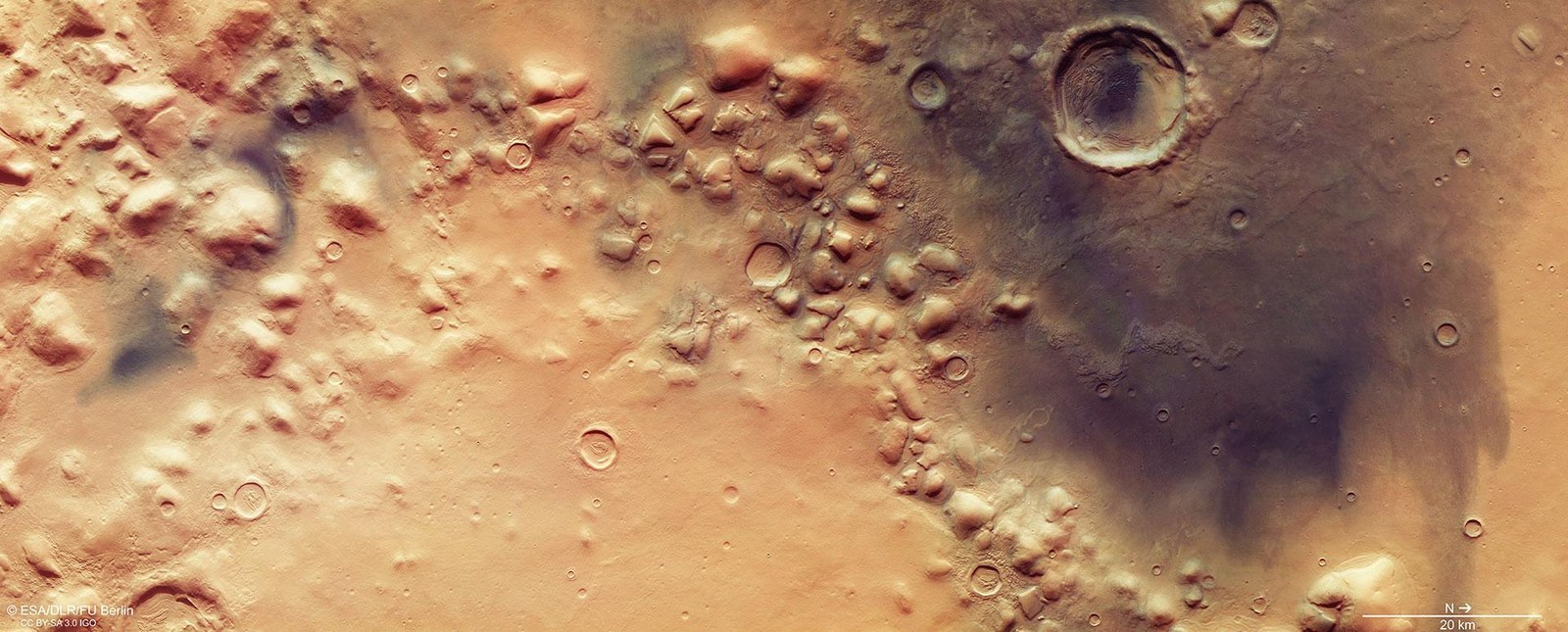
Ice and wind have left their mark on Colles Nili, a region characterised by numerous inselbergs or ‘escarpment outliers’ and marking the transition from the northern lowlands to the several thousand-metre-high Martian highlands in the south. The lowlands in the right (northern) half of the image are covered extensively by a thin layer of dark material. This is sand of volcanic origin that the wind has carried there. A large dune field has formed in the 15-kilometre-wide crater near the top of the image. The left, southern half of the image shows the transition to the Martian highlands. Between the 1000 to 2000 metre-high hills, debris-covered ice flows have shaped the landscape with streamlined moraines running in parallel.
Signs of glacial activity between the hills of Colles Nili
The ‘Hills of the Nile’ region, Colles Nili, marks the transition from the northern lowlands on Mars to the highlands in the south. This perspective view shows numerous inselbergs or ‘escarpment outliers’ – 1000 to 2000 metre high mountains that have been worn down by erosion. Numerous traces of ice flows can be identified Between these remnants of the highland that once stretched to the north. They have brought large quantities of debris with them and deposited this debris following glacial retreat. The dark colour visible in the left and upper parts of the image results from deposits of volcanic ash carried here by wind.
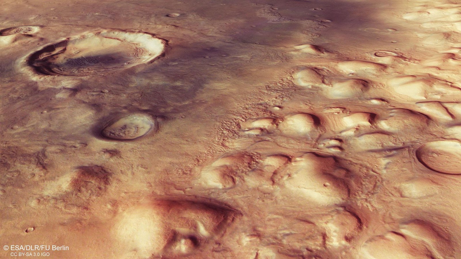
Colles Nili – escarpment outliers at the transition between the Martian highlands and lowlands
One of the most striking topographic features of Mars is its pronounced ‘dichotomy’ – its division into an older highland region littered with craters to the south of the equator and lowland plains in the north of the planet. The transition between the lowlands and the highlands is mostly marked by a steep escarpment, the foothills of which contain numerous inselbergs or ‘escarpment outliers’ that could be remnants of the highland region that have withstood erosion. In these images of Colles Nili, the ‘Hills of the Nile’ region, signs of glacier and ice activity can frequently be observed along the dichotomy boundary, which reveal heavy glaciation in the past.
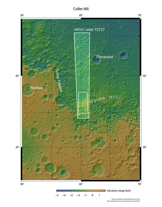
These images, acquired by the High Resolution Stereo Camera (HRSC) operated by the German Aerospace Center (Deutsches Zentrum für Luft- und Raumfahrt; DLR) on board the European Mars Express spacecraft, show structures that formed as a result of glacial activity in the Colles Nili region. The 'Hills of the Nile' lie directly on the Martian dichotomy – the boundary that separates the northern lowlands from the southern highlands.
The topographic division (Greek: dichotomy) into a northern area with lowlands and the older, southern highlands with numerous impact craters represents one of the most striking features of Earth's planetary neighbour. The cause of this has not yet been determined. Some scientists believe it is possible that the northern hemisphere of Mars was struck by a large asteroid more than four billion years ago, which acted like a 'grazing shot' that caused several kilometres of the young rock crust to be 'shaved off'. In many areas, the dichotomy boundary consists of a several kilometre-high escarpment, which marks a topographical difference between the highlands of the southern hemisphere and the low-lying northern hemisphere of Mars.
Glaciers were active at the dichotomy boundary
The Colles Nili region is located directly at the foot of the dichotomy escarpment and, amidst smooth terrain, contains several 1000 to 2000 metre high mountains that are probably the heavily eroded remains of the adjoining ancient highlands in the south. The hills are distributed across the landscape like inselbergs or 'escarpment outliers' and are surrounded by smooth, undulating deposits, known as lobate debris aprons. These are streams of rock debris and ice that moved downhill, flowing around obstacles in the landscape before coming to a standstill. In addition, deposits can be seen between the hills, which form a linear pattern on the surface and are known as lineated valley fills. These features form when masses of rock, ice and dust slowly slide down opposing slopes, meet on the valley floor and overlap.
It is likely that both lobate debris aprons and lineated valley fills form from debris-covered ice flows known as rock glaciers, and they occur along the entire Martian dichotomy boundary. These glacial deposits may have formed through the collapse of a regional, retreating ice cover, which was then increasingly covered by rock debris sliding onto the ice laterally. There may have been several episodes of glacial activity in this region over the last hundreds of millions of years. The dark material covering the hills and plains in some places is sand of volcanic origin, which can pile up to form dunes such as those within the large impact crater, for example.
Image processing
The data for the images was acquired by the HRSC during Mars Express orbit 15,727 on 29 May 2016. The image resolution is 15 metres per pixel. The centre of the images is at approximately 60 degrees east and 36 degrees north. The colour plan view was created using data from the nadir channel, which is oriented perpendicular to the surface of Mars, and the colour channels. The oblique perspective view was derived from data acquired by the stereo channels. The anaglyph, which gives a three-dimensional impression of the landscape when viewed with red-blue or red-green glasses, was produced using data from the nadir channel and one stereo channel. The colour-coded map is based on a digital terrain model (DTM) of the region, from which the topography of the landscape can be derived.
The HRSC experiment
The High Resolution Stereo Camera was developed at the German Aerospace Center (Deutsches Zentrum für Luft- und Raumfahrt; DLR) and built in collaboration with partners in industry (EADS Astrium, Lewicki Microelectronic GmbH and Jena-Optronik GmbH). The science team, which is headed by principal investigator (PI) Ralf Jaumann, consists of over 40 co-investigators from 33 institutions and ten countries. The camera is operated by the DLR Institute of Planetary Research in Berlin-Adlershof. The images shown here were generated by the Institute of Geological Sciences at FU Berlin in conjunction with the DLR Institute of Planetary Research in Berlin.
