Flight over Mawrth Vallis
Your consent to the storage of data ('cookies') is required for the playback of this video on Quickchannel.com. You can view and change your current data storage settings at any time under privacy.
ESA/DLR/FU Berlin, CC BY-SA 3.0 IGO
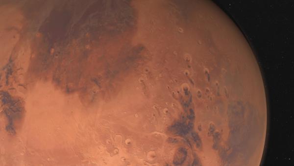
Approximately 600 kilometres long and up to two kilometres deep, Mawrth Vallis is a dried-up outflow channel on our planetary neighbour Mars. The High Resolution Stereo Camera (HRSC) operated by the German Aerospace Center (Deutsches Zentrum für Luft- und Raumfahrt; DLR) on board ESA's Mars Express spacecraft has imaged the valley in high resolution. Scientists from the Freie Universität Berlin have created a simulated overflight animation along the course of the valley from the digital terrain model calculated at the DLR Institute of Planetary Research.
Indications of the presence of water in earlier times
Mawrth Vallis (the word 'Mawrth' is Mars in Welsh) is one of the oldest valleys on the Red Planet and is located on the transition between the southern highland regions and the northern lowlands of Mars. This zone is also known as the 'dichotomy boundary'. However, many may have already come across the unusual name: It was a large part of Mark Watney's 3200-kilometre journey in Andy Weir's 2011 science fiction novel The Martian. The book was turned into a film in 2015 by Ridley Scott, in which Matt Damon was the protagonist.
The animation starts at the mouth of Mawrth Vallis and extends into the vast plain of Chryse Planitia. From there, it continues along the winding course of the valley to the source region in the four billion year old, heavily cratered Arabia Terra highlands to the north of the Martian equator.
Numerous impact craters and light and dark deposits can be seen. The light, layered sediments are among the largest deposits of sheet silicates on Mars. These clay minerals are found in numerous places and are an indication that liquid water existed in this region. On Earth, clay minerals frequently occur as a product of the weathering of volcanic rock that has been in contact with water for extended periods of time and has been transformed in the process. Hence, an analogous formation process can be assumed for these water-retaining minerals on Mars. The contrast in the individual colour channels was increased to better recognise the material differences in the rocks, dust and sand on the Martian surface. To an astronaut on Mars, the surface would appear much more monotone.
Mawrth Vallis – a life-supporting environment in the past?
Mawrth Vallis is one of the potential targets for the second part of ESA's ExoMars mission (2020), in which a rover will analyse rock samples down to a maximum depth of two metres. The valley may have been capable of supporting life in the past. This can be concluded firstly from the volume of hydrated (water-retaining) minerals that can be identified using the cameras and spectrometer data from the various Mars spcaecraft in orbit around the planet. Secondly, it is known from Earth that such clay minerals form in comparable – neither acidic nor alkaline – water. Such environmental conditions are also thought to be particularly friendly to life. Some scientists even think it is possible that traces of life might still exist in the lower layers. This is one of the reasons why Mawrth Vallis was selected as a possible landing site. Oxia Planum, Aram Dosum and Hypanis Vallis are the three other suggested landing sites for ExoMars currently under consideration.
Image processing
The underlying mosaic was compiled from nine individual orbit strips (1564, 1337, 2229, 1542, 1326, 1293, 2938, 2196, 3297). The image section lies at around 338 – 346 degrees east and 17 – 29 degrees north. The colour mosaic was created using data from the nadir channel, the field of view of which is aligned perpendicular to the surface of Mars, and the color channels of the HRSC. The mosaic image is combined with topography information (from stereo data of HRSC) to generate a three-dimensional landscape.
The HRSC experiment
The High Resolution Stereo Camera was developed at the German Aerospace Center (Deutsches Zentrum für Luft- und Raumfahrt; DLR) and built in collaboration with partners in industry (EADS Astrium, Lewicki Microelectronic GmbH and Jena-Optronik GmbH). The science team, which is headed by principal investigator (PI) Ralf Jaumann, consists of over 40 co-investigators from 33 institutions and ten countries. The camera is operated by the DLR Institute of Planetary Research in Berlin-Adlershof. The images shown here were generated by the Institute of Geological Sciences at FU Berlin in conjunction with the DLR Institute of Planetary Research in Berlin.