Fire disaster in Chile – ZKI uses FireBIRD to deliver situational information


- DLR's ZKI has prepared situation maps for the fires in Chile.
- Data from the DLR satellite TET-1, part of the FireBIRD mission, was used to prepare the maps. The Institute of Optical Sensor Systems checked the results.
- Fire reached radiative power of up to 24 gigawatts.
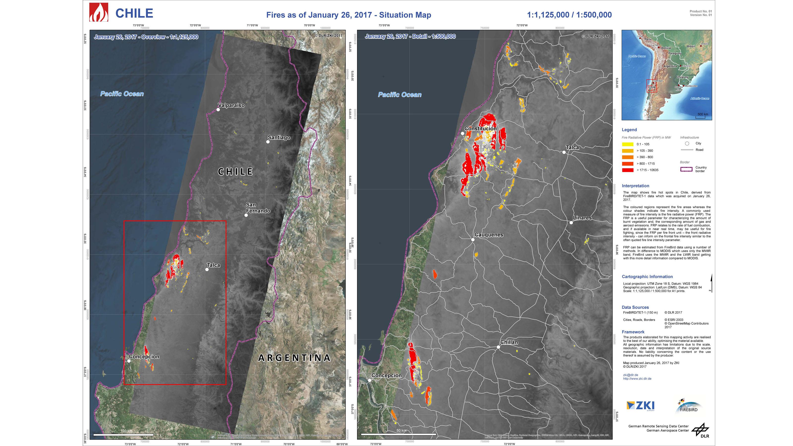
Expansive forest fires have raged through Chile for some weeks now due to a long dry spell. On 25 January 2017, the Chilean National Office for Emergency (Oficina Nacional de Emergencia del Ministerio del Interior; ONEMI) activated the International Charter Space and Major Disasters to obtain up-to-date situation images of the disaster area to assist emergency services. The Center for Satellite Based Crisis Information (Zentrum für satellitengestützte Kriseninformation; ZKI) of the The German Remote Sensing Data Center (DFD) (Deutsches Fernerkundungsdatenzentrum; DFD) within the German Aerospace Center (Deutsches Zentrum für Luft- und Raumfahrt; DLR) was tasked with coordinating the entire Charter activation. As part of their Charter activities, the staff at ZKI requested, among other things, that the Institute of Optical Sensor Systems provide data from the DLR satellite TET-1, which is part of the FireBIRD mission. The smooth internal coordination within DLR ensured that only a few hours passed from the order to the planning, sending of satellite commands, and data download and processing, before ZKI was able to send the first situation map of the fire hotspots to Chile.
Burn areas with immense radiative power
The fires in Chile are the most devastating in years. Since the outbreak of the first fires, emergency services have counted 135 active fires, 55 of which are under control and 11 have been extinguished. So far, the fires have affected a surface area of over 366,000 hectares and destroyed 1047 buildings. The satellite image taken with the mid-infrared channel of the TET-1 camera shows an area 35 kilometres wide and 60 kilometres long. The yellow to red areas indicate the fire zones; the different colours indicate the respective fire radiative power. Yellow areas are fire sources with low radiative power, for instance in shrubs. In contrast, the red areas denote particularly highly radiative power typical of entire trees that have caught fire. In addition to the huge fire zones close to the cities of Constitución and Concepción, numerous smaller fires are visible throughout the entire country.
The data provided by the small satellite TET-1 was automatically processed to create so-called fire products, in which the radiative power of fire was inferred in addition to thermal anomalies (conspicuous deviations in the land surface temperatures). The measurements were reviewed by sensor specialists at the DLR Institute of Optical Sensor Systems, who identified extreme values of up to 24 gigawatts in their analyses of fire sites. The staff at ZKI were able to use this information to prepare the up-to-date situation maps.
International disaster relief
A heatwave conflating with strong winds led to several multiplications of fires in a short period of time, prompting the Chilean authorities to declare a disaster situation on 20 January 2017. The prevailing drought and the weather forecast for the coming days, with temperatures topping 39 degrees Celsius and accompanied by strong winds, are expected to exacerbate the situation even more. Four thousand people have already been evacuated from the affected areas. All available resources nationwide have been deployed. In addition, Mexico, France, Russia and the United States have provided extra manpower. France and Russia are also contributing to situation analysis within the framework of the ZKI-coordinated Charter activities.
About ZKI
The Centre for Satellite Based Crisis Information (ZKI) supports emergency services by providing rapid satellite image maps for use in natural disasters and humanitarian emergencies. Satellite data is recorded, analysed and compiled to produce needs-based, topical maps and visualisations on very short notice, especially within the framework of the International Charter Space and Major Disasters. ZKI is integrated in national and international networks, and its staff contribute to the United Nations Platform for Space-based Information for Disaster Management and Emergency Response (UN-SPIDER).
About the FireBIRD mission
The DLR FireBIRD mission consists of two satellites, TET-1 and BIROS (Bispectral Infrared Optical System). They are both based on the small satellite BIRD (operational from 2001 to 2004), which was developed by the DLR Institute of Optical Sensor Systems. A similar system of infrared cameras is fitted to both of these satellites. TET-1 has been orbiting Earth since 2012, searching for fires and other high-temperature events. TET-1's 'brother', the small satellite BIROS, built in Berlin Adlershof, has also been in orbit since 2016, adopting an open constellation to support TET-1 on its important mission.
The satellite data is mainly received at the DLR ground station in Neustrelitz and then processed, archived and made available worldwide for scientific purposes by the German Remote Sensing Data Center (DFD). The FireBIRD satellites are operated and controlled by the German Space Operations Center (GSOC) within DLR's Space Operations in Oberpfaffenhofen.
Unlike other current satellites, FireBIRD has the capability to detect smaller fires in particular. This enables more precise mapping, and therefore analysis of their impact on the climate. Moreover, exact registration of forest and bush fires is highly relevant due to the economic loss they entail.
Construction of the BIROS satellite was funded by the German Federal Ministry of Education and Research (Bundesministerium für Bildung und Forschung; BMBF).