The Neukum Crater on Mars - Martian crater named after German planetary scientist
January 18, 2018 | Mars Express mission
The Neukum Crater on Mars - Martian crater named after German planetary scientist
Perspective view of the Neukum Crater on Mars
The digital topographical models derived from HRSC stereo image data make it possible to compute perspective views of the Martian landscape. These can often provide a much better visual understanding of geological phenomena and processes than an overhead view. The weathered crater edge and the traces of various meteorite impacts can be seen in this view.
The HRSC, which is operated by DLR on board the Mars Express spacecraft, simultaneously records the surface of Mars in high resolution images, in 3D, with four colour filters in visible light (for blue, green and red), and in near infrared wavelengths. These contrast-enhanced true-colour images produced by the colour channels and the nadir channel oriented vertically onto the surface of Mars clearly show material differences in the planet's otherwise largely monotonous surface. Particularly striking are the dark dune field within the Neukum Crater and the light-coloured deposits to the west of the dune field on the crater floor. It is not yet clear how these deposits were formed.
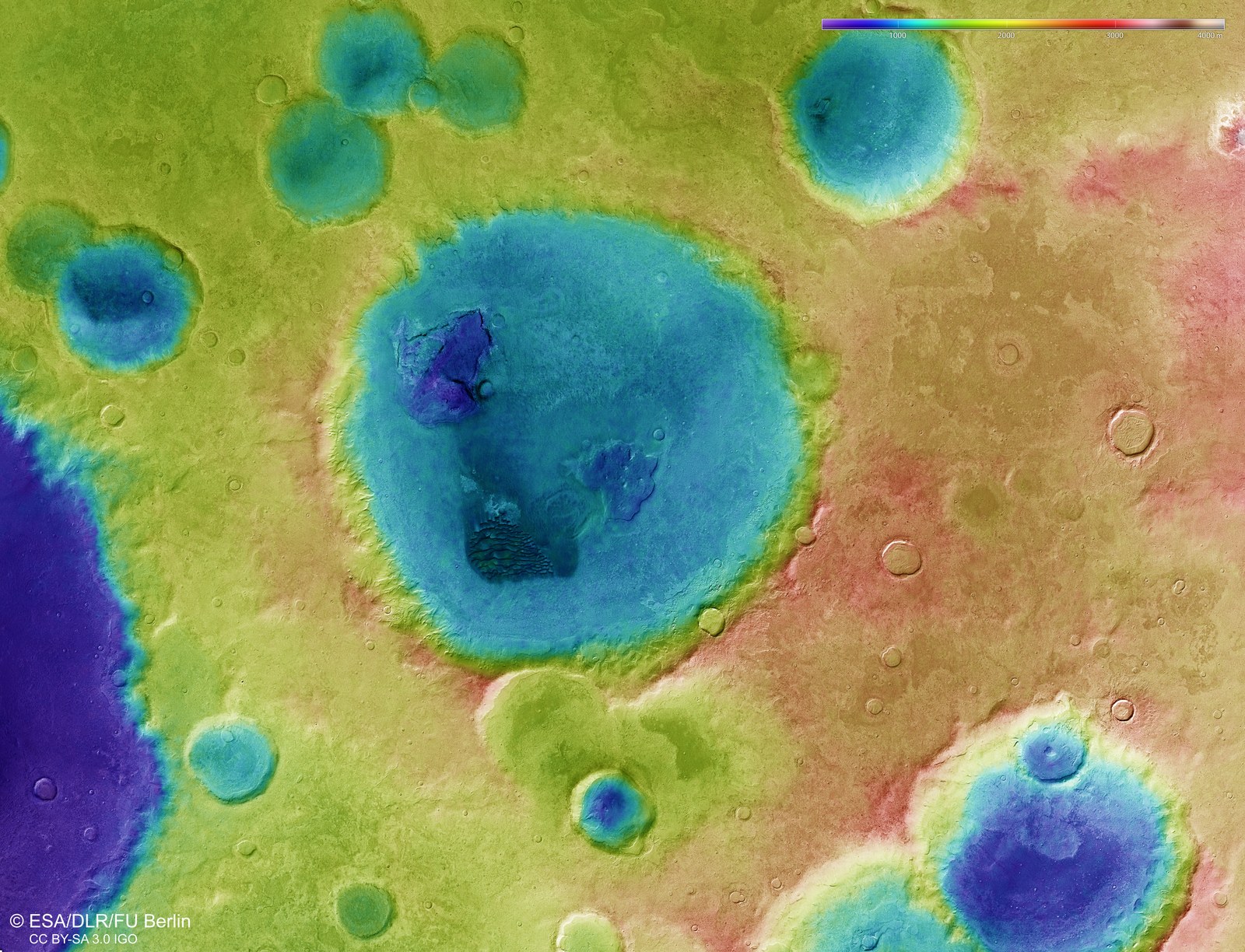
False colour image of the topography of the Neukum Crater
Digital topographical models of the surface of Mars, with an accuracy of up to 10 metres per pixel, can be derived from the nadir channel (oriented vertically onto the surface of Mars) and the stereo channels of the HRSC camera. These colour-coded images clearly depict the absolute heights above a reference level, the Areoid (from Ares, the Greek name for Mars). The elevation values can be read on the colour scale at the top right of the image.
Martian crater named after the German physicist and planetary scientist Gerhard Neukum, who passed away in 2014
Neukum developed the High Resolution Stereo Camera (HRSC)
The Neukum Impact Crater is a complex crater with dark dunes
Focus: Space, planetary research
On 29 September 2017 the International Astronomical Union (IAU) named a 102 kilometre-wide impact crater in the southern highlands of Mars after the German physicist and planetary scientist Gerhard Neukum, who passed away in 2014. During his time as a researcher at the DLR sites in Oberpfaffenhofen and Berlin-Adlershof between 1988 and 1996, Neukum developed the High Resolution Stereo Camera (HRSC), and was the Principal Investigator (PI) for this camera experiment between 2003 and 2013. On 10 January 2004, the HRSC, which is operated by the German Aerospace Center (Deutsches Zentrum für Luft- und Raumfahrt; DLR) on board the ESA Mars Express spacecraft, transmitted its first image data to Earth, and to this day it continues to send us high-quality images of the surface of Mars.
These recent HRSC images show the Neukum Impact Crater, which is located in the Noachis Terra region. This region lies in the densely cratered Martian southern highlands and is located roughly 800 kilometres from the eastern rim of the Hellas Planitia – the largest impact basin on Mars. Noachis Terra is known for its numerous dune fields, which have accumulated on the floor of large impact craters.
Video: Martian crater named after German planetary scientist
Martian crater named after German planetary scientist
Your consent to the storage of data ('cookies') is required for the playback of this video on Youtube.com. You can view and change your current data storage settings at any time under privacy.
Martian crater named after German planetary scientist
Video: Martian crater named after German planetary scientist
Credit:
DLR
A complex crater with dark dunes
Neukum Crater stands out for its complex inner structure: the eye is immediately drawn to a large, dark field of dunes and two low depressions on the crater floor. Landslide deposits and possible glacial structures can also be seen on the inner crater rim. Despite having a diameter of over 100 kilometres, the crater is only around one and a half kilometres deep. The flat crater floor indicates that the crater has been repeatedly covered and filled with sedimentary deposits since its formation approximately four billion years ago. This is also confirmed by the age of the geological features within the crater, of which the most recent are only around 66 million years old. The crater’s rim and ejecta are heavily weathered, having been struck by countless meteorites over millions of years, as well as being subjected to water and wind, and thus increasingly eroded.
A dune field within the crater measures approximately 12 by 17 kilometres. Unlike dune fields on Earth, most of those on Mars are dark, as they consist of dark, volcanic material. The shape of the dunes is longitudinal and they are oriented vertically to the prevailing wind direction, and are known as transverse eolian ridges. Individual crescent-shaped dunes can mainly be seen on the northern edge of the dune field. These merge sideways into each other on the edges of this dark dune field. Within the dune field, the slipfaces are predominantly oriented towards the west, indicating that the prevailing wind direction is from the east. In addition, winds from the east and south have blown out the fine dark sand, which has then been deposited in thin sand sheets to the north and west of the dune field. A close inspection of the dune fronts reveals several small sand avalanches pointing down the slopes. These indicate that the dunes are still active and that their surfaces have not solidified.
Also striking are the light-coloured deposits on the crater floor, to the west of the dune field. It is not yet clear how these deposits were formed. This may be rock material that is resistant to weathering and has been left exposed, or chemically solidified sediments.
Image processing
The mosaic consists of three orbit strips (2529, 4346, 4357) and covers a region 26 to 31 degrees East and 42 to 47 degrees South. The colour mosaic was created using data from the nadir channel, the field of view of which is aligned perpendicular to the surface of Mars, and the colour channels of the HRSC. The oblique perspective view was generated using data from the HRSC stereo channels. The colour-coded topographic view is based on a digital terrain model of the region, from which the topography of the landscape can be derived. The reference body for the HRSC-DTM is a Mars equipotential surface (Areoid).
The HRSC on board Mars Express
The High Resolution Stereo Camera was developed at the German Aerospace Center (DLR) and built in collaboration with partners in industry (EADS Astrium, Lewicki Microelectronic GmbH and Jena-Optronik GmbH). The science team, which is headed by Principal Investigator (PI) Ralf Jaumann, consists of 51 co-investigators from 35 institutions and 11 countries. The camera is operated by the DLR Institute of Planetary Research in Berlin-Adlershof.