September 14, 2018 | Permafrost monitoring with latest radar technology in German-Canadian cooperation
Thawing Arctic in radar view
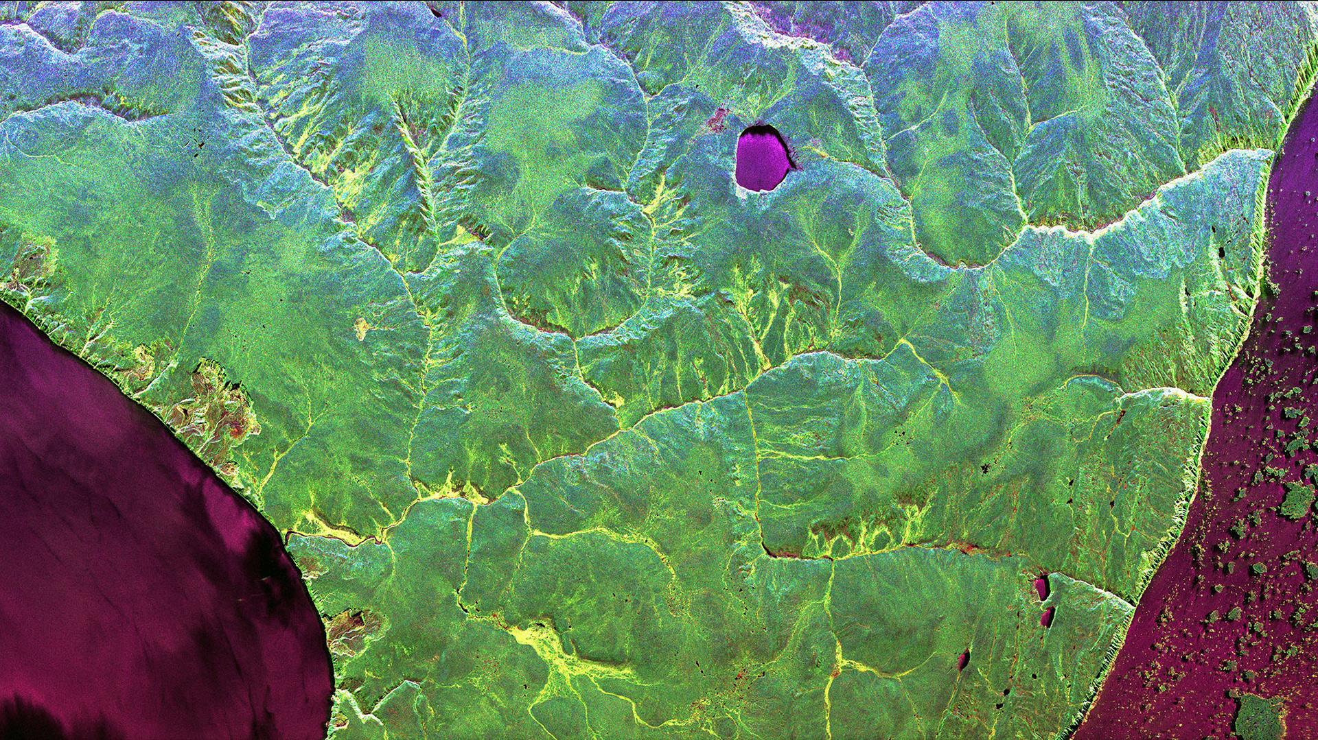
Permafrost region Herschel Island
Herschel Island is located on the northwestern tip of Canada and is characterised by continuous permafrost. The PermASAR radar image acquired in August 2018 reveals vegetation in the L-band frequency range (dark green colour) in the otherwise treeless tundra. The thawing process is also evident along the coasts: In the right part of the picture, broken ice floes float on the sea (violet). On the coast in the left part of the image are traces of mudflows where the thawed soil breaks off and is washed away.
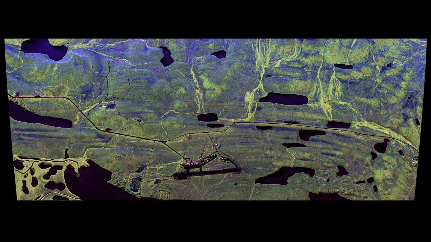
Havikpak Creek is located north of Inuvik in northwestern Canada. The permafrost region borders the taiga and is occasionally covered by boreal forest. The radar signal in the low-frequency L-band penetrates deeper into the vegetation, down to the ground, and thus allows statements to be drawn about the volume or the biomass of the vegetation. In the picture area on the top right, the forest areas (light green) are clearly visible.
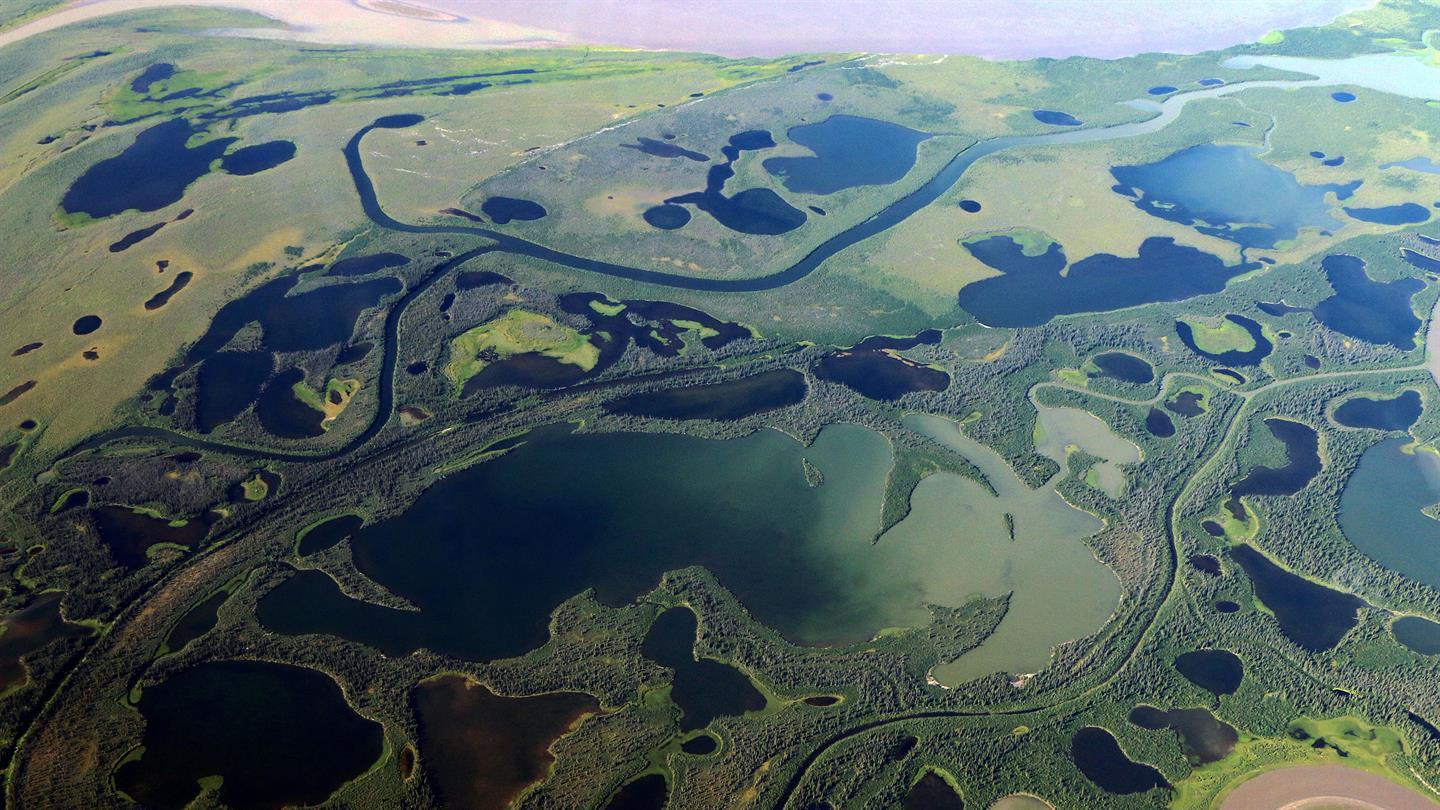
The aerial photograph was taken as part of the ‘Vegetation Transect’ measurements of the PermASAR campaign in August 2018. It shows a glimpse of the area north of Inuvik, towards the Mackenzie River Delta. The Mackenzie River runs through the Northwest Territories of Canada. The main branch of the river is visible at the top of the image.
Project PermASAR: succesfully completion of measurement flights over the permafrost region of Canada
Novel radar technologies and analytical methods enable monitoring of the Arctic with regard to climate change
Possible applications for current and future satellite missions such as Tandem-L
Focus: climate change, Tandem-L, aeronautics, space
Scientists from the German Aerospace Center (Deutsches Zentrum für Luft- und Raumfahrt; DLR) Microwaves and Radar Institute are developing special radar technologies and analytical methods that enable the highly accurate observation of permafrost. As part of DLR's Permafrost Airborne SAR Experiment (PermASAR), they are carrying out extensive measurement flights over the permafrost region of Canada. The first measuring campaign, which surveyed 10 test sites along a 2000-kilometre-long North-South gradient – from boreal forests in Northern Saskatchewan up to the Canadian Arctic coastline – has now been successfully completed. DLR is cooperating with the Canada Centre for Mapping and Earth Observation (CCMEO).
For millennia, permafrost has been shaping the subsoil of the Arctic and subarctic latitudes, ranging from a few meters to more than one kilometer deep into the interior of the Earth. However, over the past decades global warming has caused the permanently frozen soil to thaw dramatically. The emission of the greenhouse gases methane and carbon dioxide is particularly critical. These gases are in the ice, bound up in huge quantities of dead plant remains, and are increasingly being released into the atmosphere.
In contrast to ground measurements, which are spatially limited and would be particularly difficult to conduct in remote regions such as the Canadian Arctic, Earth observation from space enables comprehensive and continuous observation of the permafrost. Radar satellites such as the current German TerraSAR-X and TanDEM-X satellites, the recently proposed future mission Tandem-L and the soon to be launched RADARSAT Constellation Mission of the Canadian Space Agency (CSA) are ideally suited for such operations, as their operation is independent of daylight and weather conditions.
"The international research community has a pressing need for a database in order to fully understand and predict the origins and effects of global climate change. DLR can make an important contribution towards this with radar remote sensing – particularly through highly innovative satellite missions such as Tandem-L. The findings from the PermASAR measurements are essential for preparing Tandem-L, which will in future make it possible to visualise the dynamic processes taking place in the Arctic on a weekly basis," explains Pascale Ehrenfreund, Chair of the DLR Executive Board.
Along the climate and vegetation gradients
From the Inuvik and Yellowknife stations in the Canadian Northwest Territories, the project team from the DLR Microwaves and Radar Institute investigated a total of 10 test sites. The measuring flights went from the northwestern tip of Canada, with its treeless tundra and continuous permafrost, to the south, over taiga regions with isolated forest areas and intermittent permafrost, all the way to the permafrost-free prairie of Saskatchewan, with its sweeping boreal forests and wetlands.
DLR deployed its Dornier Do 228-212 research aircraft, as it is ideally suited for remote sensing missions due to its robust design and numerous modifications, and is operated by DLR's Flight Experiments facility. The operations team is also responsible for flight planning and supports the scientists before and during the mission. The research aircraft was equipped with DLR's F-SAR radar system and recorded polarimetric and interferometric Synthetic Aperture Radar (SAR) data in four frequency ranges – X-, C-, S- and L–band – for the PermASAR measurements.
Together with innovative 3-D radar technologies – the so-called SAR tomography – the different frequency ranges allow the scientists from Oberpfaffenhohen to carry out comprehensive analysis of the vegetation and different environmental systems. Initial evaluations already show the diversity in the vegetation and soil of the test sites and the related information content of the image data from the different frequencies. For example, the measurements in L-band make it possible to detect differences between various soil conditions beneath the vegetation due to the long-wave radar signals.
Quantifying changes
The last four weeks of August were deliberately chosen to record the properties of the permafrost for the current PermASAR measuring campaign, as the soil has different thawing depths in summer. To gain insights into the state of the permafrost regions that are completely frozen up to the surface, the PermASAR team will carry out a second measuring campaign in spring 2019 and fly over the same Canadian test sites again using the F-SAR instrument. This will allow the radar experts from DLR, CCMEO and other research partners to observe and characterise the seasonal changes occurring in the Arctic.
The full set of PermASAR measurements will open up new applications for radar remote sensing and deepen our understanding of permafrost development. The comprehensive measurements form a unique database that now enable the scientists to develop new algorithms for optimal data analysis to determine biophysical and geophysical parameters. In addition to characterising the vegetation, obtaining information about the thawing depth and surface structure of the permafrost soil, areas of ground uplift or subsidence and the characteristics of thermokarst are also of interest for climate and environmental research.
This is particularly important in view of the current, newly concceived radar satellite mission Tandem-L. Despite today's new approach to Earth observation – towards special geo information for the end-user – only a few missions directly provide environmental and climate-related information with high temporal and spatial resolution. However, this is a prerequisite for understanding the dynamic processes of the Arctic and other ecosystems – which is at the core of Tandem-L.
Cooperation with Canada
PermASAR is already considered to be a flagship Earth observation project for the collaboration between DLR and Canada in the field of Earth Observation. The cornerstone for this is the successful cooperation for receiving satellite data via the Inuvik Satellite Station Facility (ISSF) in the Canadian Arctic. The Canada Centre for Mapping and Earth Observation (CCMEO) operates the station near the North Pole and is a founding partner together with DLR. The ISSF is crucial for the seamless data reception of the German radar satellite mission TanDEM-X and will celebrate its tenth anniversary next year. Additionally, in future, the ISSF will not only be prepared for future satellite missions such as the RADARSAT Constellation Mission and Tandem-L, but also provide additional services next to demanding data traffic.
The Canadian partners are planning on setting up a data evaluation centre in Inuvik, which, next to operational geo-information services, will also promote research and education locally. Among others, the Aurora Research Institute, which has been working closely with DLR for many years, is also involved in Inuvik. PermaSAR now complements the cooperation in the Arctic on both a scientific and on an application-oriented side. DLR and CCMEO are thus working on pioneering technologies and methods of radar remote sensing from space to better understand the fragile ecosystem of the Arctic to provide targeted protection against climate change.


