Uparching, stress and strain on Mars – the horst and graben landscape of Ascuris Planum
May 14, 2020 | Mars Express mission
Uparching, stress and strain on Mars – the horst and graben landscape of Ascuris Planum
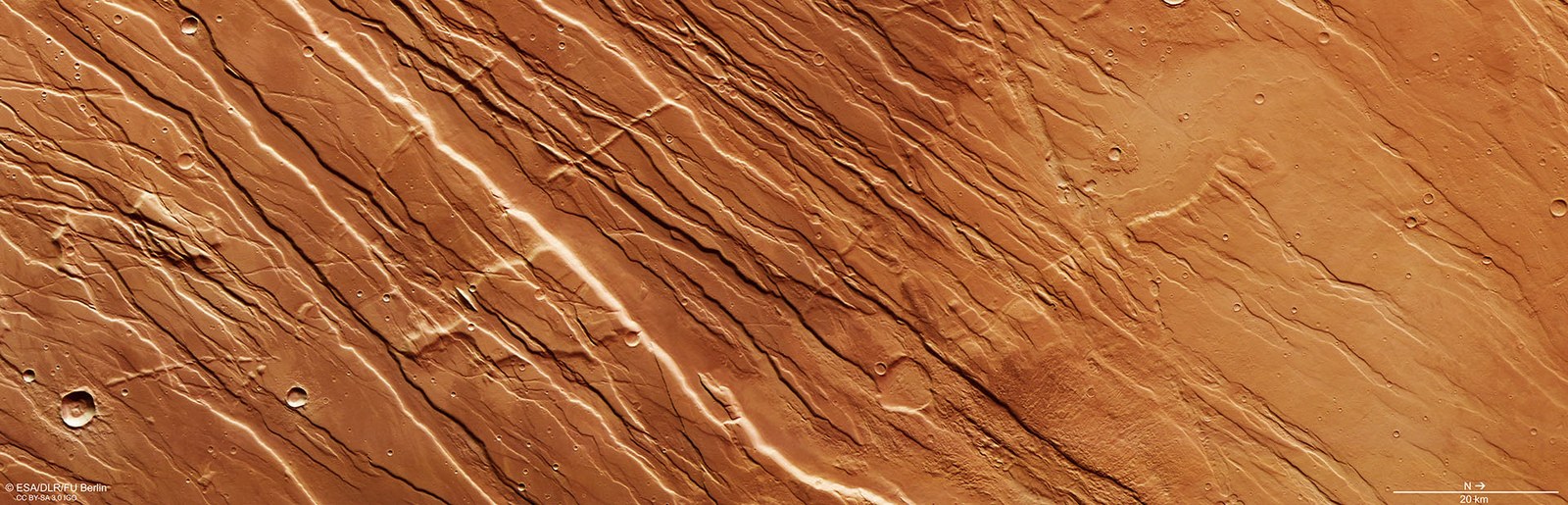
Vertical plan view of the horst and graben landscape of Ascuris Planum
This 200 by 80-kilometre section of Ascuris Planum is a textbook example of the parallel ridges referred to as a ‘horst and graben’ structure. These are created by tectonic forces. If a rigid, brittle rock crust is stretched, due to rising subsurface material, for example, the surface above undergoes tension. If the tensile stress rises above a certain limit, the crust breaks up along steeply sloping fracture surfaces, creating a ‘fault zone’. If the crust continues to expand, large blocks of rock slide down the fracture surfaces several hundred metres, or even one to two thousand metres, forming a tectonic graben. The blocks left standing on both sides now tower above the landscape and form the associated horsts.
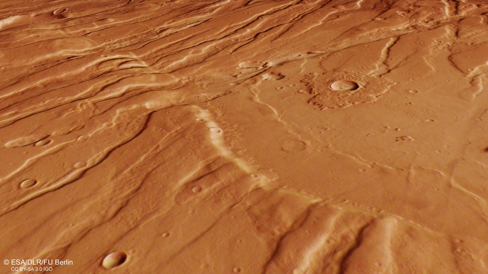
Oblique perspective view of horsts and grabens in Ascuris Planum
Tectonic forces have created a characteristic pattern of parallel, linear fracture structures in Ascuris Planum, the northernmost part of the Tempe Terra region to the northeast of the Tharsis Ridge. As a result of rising magma pockets, the Martian crust was stretched, causing crustal blocks to subside along fracture surfaces and form tectonic grabens. In between, the horsts remained as raised crustal blocks. The grabens are partly filled by debris-covered glaciers, which are characteristic of all steeper slopes at these latitudes. The ejected material of a small crater (centre right of the image) rises like a platform above the surrounding landscape. Such crater surroundings are formed when the ejected material is much more resistant to erosion processes than the surface rock. They form an erosion-resistant layer which, after the surrounding material has been removed, create a plateau around the crater.
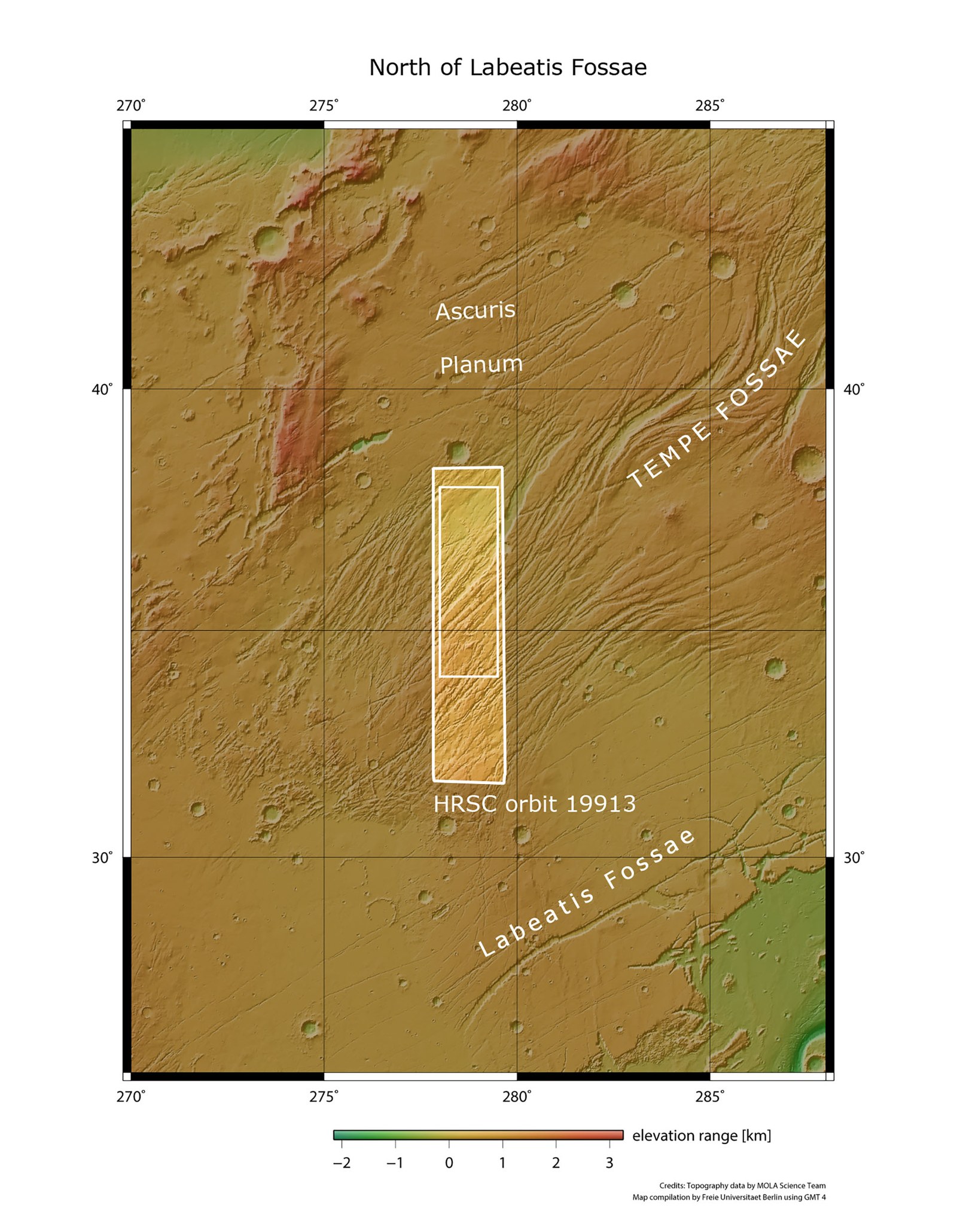
Located to the northeast of the large volcanic region Tharsis on Mars, Tempe Terra is an area that has been strongly influenced by tectonic forces. During the uplifting and stressing of the lithosphere by volcanic and plutonic rocks over billions of years, enormous tensile stresses in the Martian crust transformed large regions into what are referred to as ‘horst and graben’ landscapes. The surface is characterised by numerous tectonic stress structures, shield volcanoes, solidified lava flows and glacial structures. The fracture structures (small rectangle), shown here in images acquired by the High Resolution Stereo Camera in September 2019, during orbit 19,913, show the southwestern foothills of the Tempe Fossae grabens. These are over 1000 kilometres long and they can be compared to that of the Kenya Rift on Earth, part of the East African Rift.
These images of Mars, acquired by the HRSC camera operated by DLR, show signs of enormous tectonic forces acting on the planetary surface.
The imaged area is located northeast of the large volcanic region of Tharsis, a magmatic bulge approximately five kilometres high. During its formation, enormous tensile stresses occurred in the Martian crust, transforming large regions into horst and graben landscapes.
The fault structures shown here are extensions of the Tempe Fossae troughs. These are over 1000 kilometres long, and their characteristics are strikingly similar to the Kenya rift.
These images show a landscape deformed by strong tectonic activity in the area north of Labeatis Fossae in the Tempe Terra region of Mars. They were acquired by the High Resolution Stereo Camera (HRSC), operated by the German Aerospace Center (Deutsches Zentrum für Luft- und Raumfahrt; DLR), on board ESA's Mars Express spacecraft. Here, the results of the enormous forces that once affected the Martian crust as large magma pockets rose from below can be seen. These pockets lifted the crust upwards and triggered volcanic and tectonic activity. HRSC has been mapping the Red Planet since 2004, as part of ESA's Mars Express mission. It was developed and is operated by DLR.
The area depicted is located northeast of the large volcanic region of Tharsis, where there are many other similar geological structures. The Tharsis region has a diameter of several thousand kilometres, making it almost as large as Europe. Tharsis is a magmatic bulge, approximately five kilometres tall, and was formed over the course of several billion years. During the gradual upwelling and stressing of the lithosphere by volcanic and plutonic rocks, enormous tensile stresses occurred in the Martian crust, transforming large regions into 'horst and graben' landscapes.
Tempe Terra is the northernmost highland region on Mars. The landscape is characterised by numerous tectonic expansion structures, shield volcanoes and solidified lava flows. The fracture structures shown here are in the south-western foothills of the Tempe Fossae troughs, which are over 1000 kilometres long and whose characteristics can be compared to that of the Kenya Rift on Earth, which is a part of the East African Rift.
How do horst and graben structures develop?
The region shown in these HRSC images is a textbook example of horst and graben tectonics. If a rigid, brittle rock crust is stretched, for example when the ground below it is raised, the surface experiences tension. If the tensile stress rises above the tolerable limit for the rock, the crust breaks up along somewhat steeply sloping fracture surfaces and a 'fault zone' is created. If the crust continues to expand, large blocks of rock slide down along the fracture surfaces for hundreds of metres, and even up to 1000 or 2000 metres in places. Over many millions of years, tectonic grabens develop. The regions left standing on both sides now tower above the landscape and form the corresponding horsts. The word pair 'horst and graben' have their origins in early medieval miners' German and were incorporated into many languages following geology’s establishment as an 'Earth science'.
A change in the stress regime
Tempe Terra is a part of the Martian crust that must have experienced high tectonic stress over a very long period of Martian history. The grabens run mostly parallel from northeast to southwest. However, there are also grabens that cut across this primary direction. This indicates a change in the orientation of the stress field. Particularly in the south (to the left of Image 1), some fractures run almost perpendicular to the prevailing direction of the faults.
Varied landscape
In the north (to the right of image 1), the landscape has a much smoother profile. The grabens are partly filled by debris-covered glaciers, which are characteristic of all steeper slopes at these latitudes. What are referred to as 'wrinkle ridges' can be seen at the top of the image. These were formed in the Tempe Terra region by compressive stress and form a concentric ring around the entirety of Tharsis. Erosion processes have also shaped this northern part of the region. The ejected material of a small crater (on the right of Image 1 and the upper right of the perspective view) rises like a platform above the surrounding landscape. These types of crater are formed whenever the ejecta are significantly more resistant to erosion processes than the surface rock. They form an erosion-resistant layer which, after the surrounding material has been removed, creates a plateau around the crater.
Image processing
The images were acquired by the High Resolution Stereo Camera (HRSC) on 30 September 2019 during Mars Express orbit 19,913. The image resolution is approximately 15 metres per pixel. The image centre is located at 279 degrees east and 36 degrees north. The perpendicular colour view was generated from the data acquired by the HRSC nadir channel, which is directed perpendicular to the Martian surface, and the colour channels. The oblique perspective view was computed using a Digital Terrain Model (DTM) and data from the nadir and colour channels of HRSC. The anaglyph image, which gives a three-dimensional impression of the landscape when viewed with red-blue or red-green glasses, was derived from data acquired by the nadir channel and the stereo channels. The colour-coded image map is based on a DTM of the region, from which the topography of the landscape can be derived. The reference body for the HRSC DTM is an equipotential surface of Mars (areoid).
HRSC was developed and is operated by the German Aerospace Center (DLR). The systematic processing of the camera data was performed at the DLR Institute of Planetary Research in Berlin-Adlershof. Personnel at the Department of Planetary Sciences and Remote Sensing at Freie Universität Berlin used these data to create the image products shown here.
The HRSC experiment on Mars Express
The High Resolution Stereo Camera (HRSC) was developed by the German Aerospace Center (Deutsches Zentrum für Luft- und Raumfahrt; DLR) and built in collaboration with partners in industry (EADS Astrium, Lewicki Microelectronic GmbH and Jena-Optronik GmbH). The science team, which is headed by Principal Investigator (PI) Ralf Jaumann, consists of 50 co-investigators from 35 institutions in 11 countries. The camera is operated by the DLR Institute of Planetary Research in Berlin-Adlershof.
