VESTEC – interactive supercomputing for rapid decision-making in emergency situations
December 11, 2020
VESTEC – interactive supercomputing for rapid decision-making in emergency situations
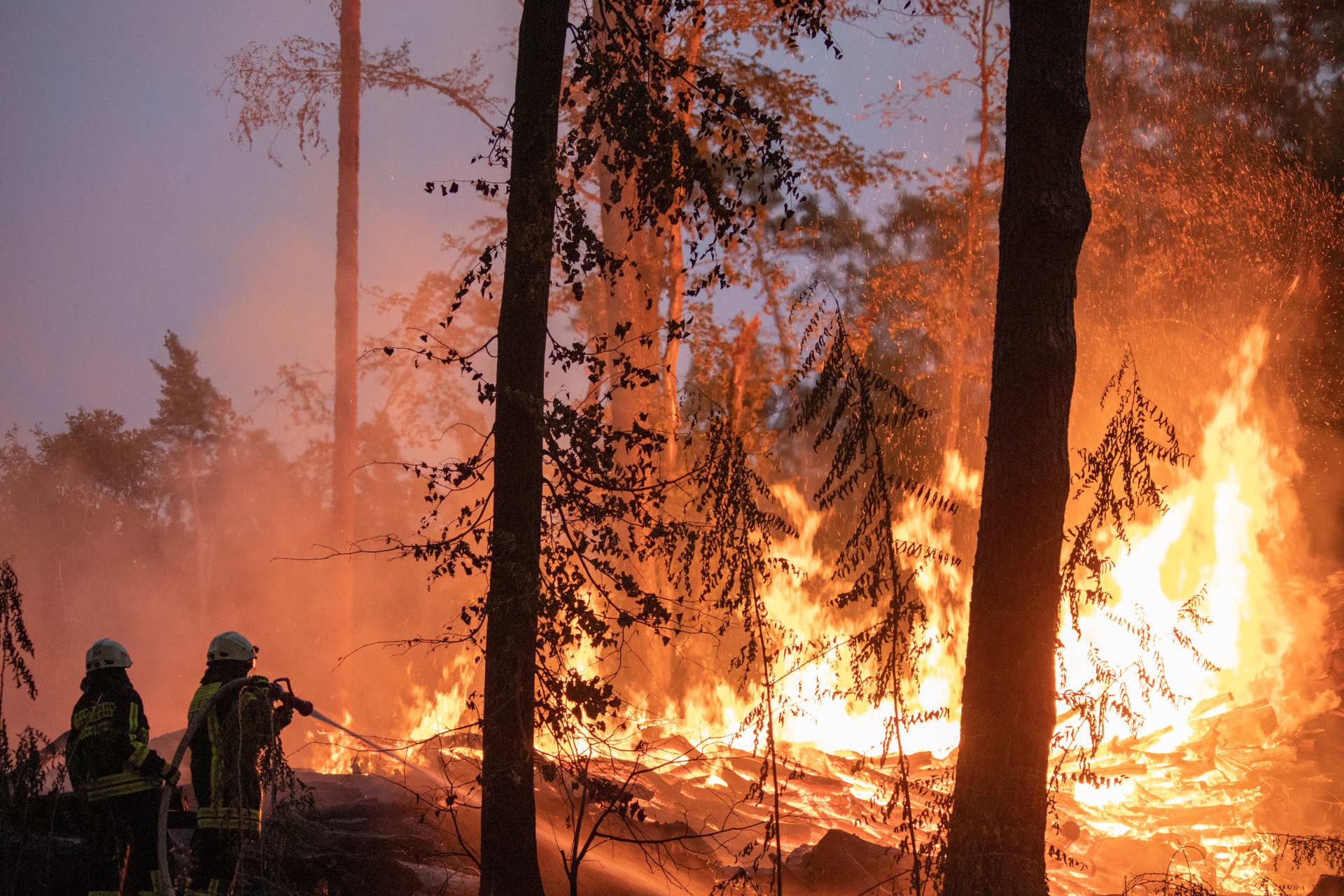
Fire brigade fighting forest fires
Maintaining an overview of large fires is a major challenge for emergency services. In the future, supercomputer-generated, up-to-date and interactive situational images will facilitate decision-making in the operations centres and help provide assistance where it is most urgently needed.
An important function of VESTEC is the visualisation of the calculated data. A large amount of information is prepared for this purpose and presented in an easily understandable way. This allows different possibilities to be analysed quickly and intuitively to avoid potentially life-threating outcomes when controlling rapid response forces during fast-developing situations on the ground.
Your consent to the storage of data ('cookies') is required for the playback of this video on Quickchannel.com. You can view and change your current data storage settings at any time under privacy.
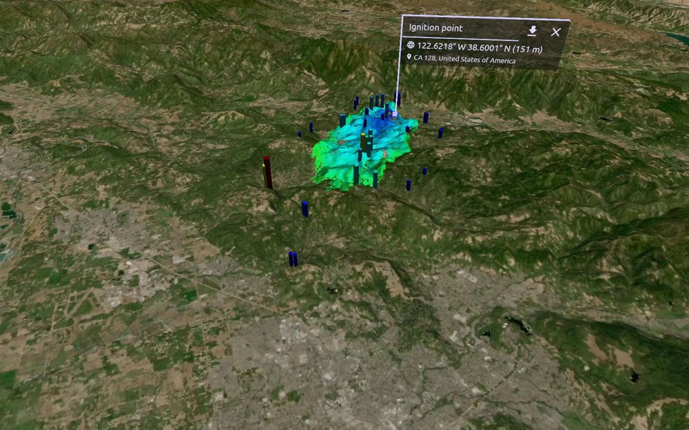
Visualisation and prediction of fire events
An important function of VESTEC is the visualisation of the calculated data. A large amount of information is processed for this purpose and presented in an easily understandable way. This allows different possibilities to be analysed quickly and intuitively to avoid potentially life-threating outcomes when controlling the rapid response forces during fast-developing situations on the ground.
Since 2018, the number of forest fires has risen worldwide. There have been more than 1500 forest fires in Germany alone in each of the last three years. During 2020, the devastating fires in Australia and California showed the extent and intensity that such blazes can reach. Maintaining an overview in this kind of dynamic situation presents emergency personnel with considerable challenges. Up-to-date interactive situational images generated using supercomputers are intended to facilitate decision-making in operations centres as well as the deployment of assistance to the places where it is most urgently needed.
Research institutions and companies from many different EU countries are pooling their knowledge as part of the Visual Exploration and Sampling Toolkit for Extreme Computing (VESTEC) project, which focuses on interactive supercomputing for rapid decision-making in emergency situations. The Institute for Software Technology at the German Aerospace Center (Deutsches Zentrum für Luft- und Raumfahrt; DLR) is coordinating this large-scale project.
Together with the other project partners, the Institute for Software Technology is developing VESTEC, a software solution with many potential applications, with the aim of enabling rapid decision-making despite large quantities of information. This is done using datasets that are collated and analysed in real time. VESTEC makes it possible to combine data sources and extract essential information efficiently. Interactive supercomputing allows for flexible and situation-dependent planning at all times. Time-critical phenomena can be modelled accurately in the form of 3D visualisations of the evaluated data.
It will be possible to use the software for a wide range of crisis and emergency situations. Three different test scenarios have been selected, with a view to developing a flexible and comprehensive tool:
Forest fire monitoring and forecasting
Risk analysis for mosquito-borne diseases
Effects of space weather on Earth (including the impact on technology supply chains)
Close to reality
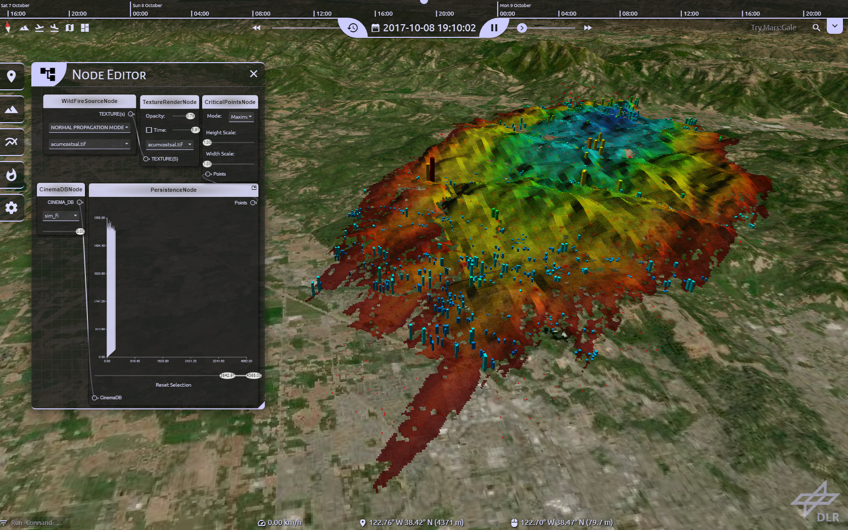
The project was launched in 2018 and the technology was applied and demonstrated in its first test scenario (pilot use case), ‘Forest fire monitoring and forecasting’, in autumn 2020. Real information from a forest fire that occurred in La Jonquera, Spain, in July 2020 was integrated for that purpose.
On the basis of this use case, the behaviour of forest fires can be analysed and evaluated; this includes examining the development of small local hotspots, the spread of wildfires and the impact of weather conditions on the course of fires.
All of the potential spread scenarios can be quickly calculated with the help of supercomputers on the basis of the latest measurement data and transmitted to crisis managers in operations centres. And this is not just a one-time calculation. Rather, the calculations are constantly being updated as soon as the input data changes. In addition to calculating changes to the potential spread of the disaster, high-performance computers can also offer much better predictions. To give one example, extremely complex algorithms can be used for highly accurate weather forecasting. Knowing in which direction a fire is spreading is important for evacuating people at risk and for creating firebreaks in a timely manner.
Visualising the information
One factor that should not be underestimated is the visualisation of the calculated data. A large amount of information is processed for this purpose and presented in an easily understandable way. This allows different scenarios to be analysed quickly and intuitively, so that potentially life-threatening outcomes can be avoided when managing the crisis response teams during fast-developing situations on the ground.
First, the VESTEC software retrieves satellite data for a predefined area in real time. Small local fires are pinpointed by analysing the images. This information is combined with global weather data from NASA. Data at a higher resolution, complete with local information such as wind direction, is provided by the University of Toulouse, based on input from the French weather service. This up-to-date information is combined and processed by the ARCHER supercomputer at the University of Edinburgh to create a forest fire simulation. This processs allows different scenarios to be analysed within a very short space of time. Finally, all of these data are used to create a visualisation. With an understandable visual representation, decision-makers are able to act quickly on the basis of real-time data and initiate appropriate responses. In the example used for the demonstration, the fire brigade could be deployed quickly and in a targeted manner to prevent the devastating consequences of a wildfire.
Allocation of VESTEC project tasks
Two departments at the DLR Institute for Software Technology are involved in the project. Performance monitoring is conducted by the High-Performance Computing Department. To be used successfully in a crisis situation, the software must be able to deliver results that can be evaluated as rapidly as possible. Processes such as collecting global weather data and transmitting it to a suitable supercomputer are checked for efficiency, and critical points in the process chain are identified.
The visualisation tool for future VESTEC use cases is being created by the Software for Space Systems and Interactive Visualization Department. This department is also responsible for the management of the project. The tool is being further developed on the basis of DLR’s CosmoScout VR software, allowing parallel scenarios to be calculated and visualised.
German Aerospace Center (DLR), Cologne, Germany EPCC at the University of Edinburgh, Edinburgh, UK Kungliga Tekniska Hoegskolan (KTH), Stockholm, Sweden Sorbonne Université, Paris, France Kitware SAS, Villeurbanne, France INTEL Deutschland Gmbh, Feldkirchen, Germany Fondazione Bruno Kessler, Trento, Italy Université Paul Sabatier, Toulouse, France
Contact
Andreas Gerndt
Deputy Director
German Aerospace Center (DLR)
Institute for Software Technology
Lilienthalplatz 7, 38108 Braunschweig
Michel Winand
Corporate Communications Aachen, Bonn, Cologne, Jülich, Rheinbach and Sankt Augustin


