The research group Mission Engineering is focused on the overall view of satellite SAR missions. This involves aspects like the overall observation strategy, the acquisition planning, and the monitoring of the acquisitions and the system. The group is involved in the early analyses, implementation and operation of a SAR mission (Phase A to E). This comprises the analysis of mission relevant aspects, the design of operational tools, the commissioning/calibration of the system and the continuous use and maintenance during the operational phase of the mission.
Tasks
Observation Strategy and Acquisition Planning
Current satellite SAR systems evolve from systems for single, dedicated acquisition into “mapping machines” for the global monitoring of the Earth system. This requires a coherent and global observation strategy. Actual and future SAR missions derive maps of the elevation of the whole earth, of its biomass distribution, or enable the continuous mapping of geomorphologically interesting areas. Therefore, a global acquisition concept is required. The global observation concept is derived during the planning phase before a SAR mission is launched.
For this purpose, all relevant parameters like acquisition modes and their data rates, the capacity of downlinks and the areas that shall be acquired are connected to a coherent concept. Orbit analyses are incorporated in these concepts, from which orbit parameters and orbit scenarios are derived. During the mission, the acquisition scenarios have to be adapted to actual needs to successfully accomplish the mission.
Acquisition Monitoring
In close relation with the acquisition strategy is the monitoring of the acquisitions and their quality. On a global scale, maps with the coverage of the acquisitions and different performance parameters are generated in order to get a global view of the data quality and completeness. On local scale, failed acquisitions need to be detected and recovered to ensure data completeness. A close loop back to the acquisition planning is established for this purpose.
System Monitoring
The long-term monitoring of a SAR system in orbit is an important task during the operational phase. With the monitoring, the overall system status is determined and long-term trends can be detected and compensated for. This is necessary to ensure the stability of the system and the quality of the acquired SAR images. Therefore, long-term monitoring reports covering the most relevant system parameters are generated and analyzed.
The TanDEM-X mission derives a global digital elevation model and exploits the bi-static satellite formation for scientific experiments.
In the mission TanDEM-X, the main focus of the group lies on the dedicated planning of the acquisitions for the global digital elevation model (DEM) and its update. Also the planning of scientific acquisitions is performed by the group considering acquisition requests and special demands from the scientific SAR community. The acquisition requests entered by the scientists via the TanDEM-X Science Server are planned with respect to temporal and baseline constraints. The acquisition parameters to obtain the desired mode are calculated and the acquisitions are ordered. Directly connected to this planning is also the optimization of the helix formation both satellites are flying in, which determines the height of ambiguity and thereby the height accuracy of the DEMs.
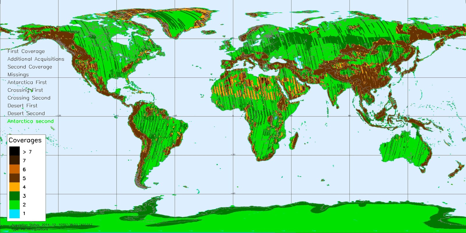
To monitor the quality of the acquisitions, global maps are derived and dedicated analyses concerning the relevant interferometric parameters are performed. These are again input for the future planning. Figure 1 shows a global overview about the acquisitions planned and acquired for the global TanDEM-X DEM. The hitherto generated tiles of the global DEM show excellent height accuracy and a high degree of detail compared to existing DEMs like SRTM.
Figure 1: DEM acquistions overview
Number of TanDEM-X acquisitions performed for the global digital elevation model.
Also the calibration of the interferometric system and the baseline between both satellites is covered by the group. During the different mission phases, the instrument delays and phase offsets between both satellites are analyzed and compensation measures are derived to be applied in the interferometric processor and the baseline calibration processor.
Tandem-L
Tandem-L is a mission proposal for an environment monitoring mission on global scale. In the Tandem-L mission, the group is involved in the derivation of a consistent acquisition plan and in the ground segment project management. In comparison to the TanDEM-X mission, Tandem-L is a much more complex mission. Various scientific applications (like deformation measurement, forest structure estimation, ice and glacier mapping, or ocean monitoring) have to be served with different demands on acquisition frequency, season, baseline, mode, resolution and accuracy. Besides these requirements, different other components are incorporated for the observation concept. One example is the amount of ground stations which limits the data volume that can be acquired and dumped. This data volume on the other hand depends on the instrument settings. Finally, the flight parameters like orbits and baselines determine the sensitivity of the system. All these inputs are merged and optimized to obtain a coherent observation concept, resulting in an acquisition timeline as shown in Figure 2. All this makes the mission proposal an exciting challenge from an acquisition planning perspective.
Big satellite projects also require an extensive project management. For the Tandem-L project, the group is responsible for the ground segment project management in the current phase.
Figure2: DEM acquistions overview
Number of TanDEM-X acquisitions performed for the global digital elevation model.


