
ERS

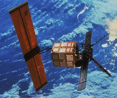
Since 1991 a large amount of earth observation data from European and German satellite missions has been received with the help of the O’Higgins station. Data from the European Remote Sensing Satellites ERS-1 and ERS-2 provide valuable insights into the changes undergone by the Antarctic ice shield over the past 20 years. Therefore, the operation of this Antarctic station has contributed to a better understanding of changes in Antarctic ice shelf dynamics, the collapse of ice shelves at the Antarctic Peninsula, ice loss in West Antarctica, the position of the margins between the continental ice sheet and floating ice shelves, and last but not least the Antarctic ozone hole.
The varying number of contacts from year to year was caused by restrictions related to the limited time for campaigns at the O’Higgins station during the Antarctic summer. After its on-board tape recorder failed in mid-2003, ERS-2 could only be operated in pass-through mode. Without on-board storage capacity available at that time, instrument data had to be downloaded directly to the ground. So data could only be acquired for regions within the visibility circles of the available ground station. For the purpose of monitoring the Antarctic ice sheet, ice shelves and glaciers the O’Higgins station collected the maximum possible amount of data from ERS. This resulted in an increased number of contacts during the summer campaigns in 2003/2004 and the following years.
Other data acquisition activities supported by the O’Higgins station included the “ERS-2 Ice Phase” project of 2011, which was responsible for the higher number of contacts in 2011. With the help of O’Higgins the revisit cycle for ERS-2 was reduced from 35 days to 3 days.