
Forestry

Pol-InSAR for forestry parameters are by far the most developed applications and a success story. Since the analysis of the first Pol-InSAR data provided by the SIR-C/X-SAR mission indicated the potential of combining polarimetry with interferometry for forest applications. As a next step, the Institute developed the sensor technology and processing expertise to acquire and process Pol-InSAR data with the E-SAR system in a repeat-pass interferometric mode. On the other side understanding, modeling and inversion techniques have been addressed and advanced in close cooperation with international partners. Early airborne experiments in the late 90s find their continuation in a series of successful Pol-InSAR demonstration campaigns across Europe (performed in cooperation with academic and commercial institutions providing in situ forest expertise) culminated into INDREX-II - a large scale airborne experiment sponsored by ESA for the demonstration of Pol-InSAR techniques in tropical forest environments.
Today, several model based forest parameter inversion approaches, which combine dual or fully polarimetric data with single or multiple baseline interferometric measurements have been proposed, discussed and validated in the frame of different ESA funded R&D studies. The main forest vegetation parameters that can be potentially estimated from polarimetric interferometric data inversion are:
- Forest height
- Forest biomass
- Forest canopy structure
Forest parameter (height & biomass) estimation from Pol-InSAR data has reached today a pre-operational stage. In the frame of ESA’s Pol-InSAR Mission and Application Study the actual status of Pol-InSAR techniques and technology has been evaluated and proved with respect to operational information product generation accounting for the technological constrains of actual and/or future satellite missions. Towards a first in-orbit demonstration the institute is member of the JAXA’s ALOS Carbon & Kyoto Initiative and responsible for Pol-InSAR forest parameter estimation. However, the expected temporal decorrelation will limit the ALOS Pol-InSAR demonstration on an "opportunity" basis. Aspiring global monitoring, the wide spectrum of scientific and technological Pol-InSAR expertise developed within the Institute culminated in HABITAT, a mission proposal for global above ground biomass inventory and change monitoring submitted in answer to ESA’s Call for Ideas for the Next Earth Explorer Core Missions in 2005.
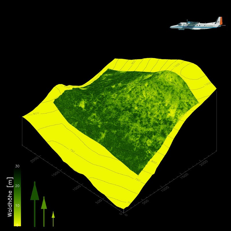
Forest height
Forest height is one of the most important parameters in forestry along with basal area and tree species or species composition. Being a standard parameter in forest inventories, forest height is hard to be measured on the ground and typical estimation errors are given with 10% accuracy, yet increasing with forest height and density. It describes dynamic forest development, modeling and inventory. Forest height estimation from polarimetric single- and multi-baseline data has been demonstrated in a series of airborne experiments over a variety of natural and as well as commercial temperate and boreal test sites characterized by different stand and terrain conditions. The validation indicates an estimation accuracy of the order of 10-20% compared to the forest top height. The estimation performance is widely independent of terrain and/or forest conditions. The results from INDREX-II verify the inversion performance at L- band (and at P-band) also for dense tropical forest conditions.
Forest biomass
Forest biomass is the most integrative forest parameter essential for ecological modeling and forest inventory and is today the big unknown in global ecosystem change modeling. The development of forest height estimation in terms of Pol-InSAR initiated the development and evaluation of allometric biomass estimation schemes in collaboration with academic institutions with expertise in forest ecology and modeling. Indeed, allometric estimation of forest biomass from forest height is robust and does not follow a saturation curve. Hence it is a good candidate for above ground biomass inventory.
This very fundamental biological (allometric) relationship between forest height and forest biomass varies only about 10-15% with site conditions and only about 15-20% across species (exceptions are very fast growing pioneer species with very light woods such as poplar and birch). This makes the estimation of forest biomass possible by only knowing forest height within 20-40% accuracy up to biomass levels of 450 t/ha, even for inhomogeneous and natural forest conditions. The achieved experimental results are in accordance with general allometric relations for different temperate, boreal and tropical forest ecosystems and with predictions of generalized forest structure models underlying the general character and thus the validity of the height-biomass relationship.
The largest uncertainties in the height-to-biomass relationship are due to density variations (natural or anthropogenic) especially in low density forest conditions, as present in boreal and savanna forest ecosystems. To reduce the biomass estimation uncertainty and increase the robustness of the methodology, the incorporation of additional information as basal area for example becomes important especially in low density, open canopy forest conditions and is an actual research topic.
Forest canopy structure
Forest canopy structure is another key forest ecosystem parameter. Regarding the estimation of forest biomass, vertical structure information is important as it allows a significant reduction of the biomass estimation error. However, the extraction of forest structure requires besides polarisation also baseline diversity in the observation vector. Dual baseline Pol-InSAR is a very promising configuration for the extraction of structure information and a trend-setting direction in the field of polarimetric interferometry.