
Vision
Images day and night and in all weathers
At the beginning of the 21st century, our society is facing challenges of global dimension: climate change, sustainable development, scarcity of resources, food security, megacities, mobility and a world-changing security situation. Up-to-date geospatial information is essential, for example, to detect changes in the environment, to understand climate change, to monitor the sustainable use of natural resources, to support precision farming, or to provide information in real time for disaster relief forces in crisis areas. Spaceborne SAR plays a vital role in this task because it is the only sensor technology that is able to provide global, high-resolution imaging during day and night and independent from weather conditions. It provides essential contributions for a wide spectrum of applications such as 2-D, 3-D, and 4-D (space-time) mapping, environmental and infrastructure monitoring, retrieval of physical parameters of land, ocean and ice surfaces, hazard and disaster monitoring as well as reconnaissance and security related applications.
High-resolution images every few minutes
In light of this unique capability of SAR systems and the user requirements for high-resolution and timely geospatial information with global access and coverage, a vision for spaceborne SAR can be formulated. A space-based sensor web consisting of a radar observatory with a constellation of satellites will provide a view of our planet like we are used to see with Google Earth, but with high-resolution images and relevant geospatial information being updated every few minutes.
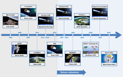
Radar satellite missions - important milestones
The way towards this vision requires many key developments in terms of innovative radar concepts, imaging techniques and technologies for which we have established a strategy and a roadmap since many years. This roadmap includes several missions which represent major milestones in this development (see Figure 1).
Future technology digital beam forming

Looking to the future on this roadmap, digital beamforming is an example of an enabling technology. One main constraint in the design of SAR systems is posed by the minimum antenna area required for suppressing the azimuth and range ambiguities. Due to this constraint it is only possible to achieve either high resolution (that is, short antenna size in flight direction or azimuth) or wide swath (that is, short antenna size in elevation or across-track).
Multichannel SAR systems
By means of a multichannel SAR system and associated digital antenna beamforming, this fundamental limitation of SAR systems can be overcome. In particular, the mission proposal Tandem-L is able to interferometrically image the whole Earth´s surface up to twice a week using a digital feed array with 32 channels in combination with a large reflector antenna of 15-meter diameter. This leads to an increase of the imaging capability by two orders of magnitude when compared to the TerraSAR-X and TanDEM-X satellites. By including digital beamforming in azimuth with several multichannel receivers, the imaging capacity can be further increased by another order of magnitude. A fully polarimetric SAR system with 400 kilometers swath and one meter resolution becomes feasible. Besides digital beamforming, further technologies and techniques are being developed in order to design a radar system concept to fulfill specific user requirements in a most effective way: MIMO-SAR, multistatic SAR, MEO-SAR and GEO-SAR.
Precise system calibration, machine learning and artificial intelligence
The Institute has also been directing its efforts towards the advancement of innovative approaches for accurate system calibration of the above mentioned advanced multichannel SAR concepts, in order to ensure improved image quality and information product reliability. Next, digital beamforming and multistatic radars can be designed for a fully software-defined operation, so that an adaptive and cognitive sensing becomes possible. As machine learning and artificial intelligence is being extensively used to improve information retrieval, a feedback loop can be established with a software-defined radar, which is able to cognitively adapt its imaging mode to optimize the information retrieval.
Interferometry, tomography, holography
We have also established a roadmap for key developments for information retrieval and innovative applications. In a general sense, the inversion of geo-biophysical parameters from SAR data is a non-trivial task due to the complex and multifaceted interaction of the electromagnetic waves with the imaged surface and volume scatterers. Model-based algorithms are required to allow a reliable and robust information retrieval. The success of such techniques increases with the amount of observables and information content available in the data. This increase in the information content can be achieved by several means including the use of time series, space diversity in the observation geometry (interferometry, tomography, holography and multistatic), multichannel data acquisition (polarimetry, multi-frequency) and signal bandwidth (geometric resolution) as well as a combination of those. However, each application poses a specific requirement on the sensor characteristics and observation scenario. The forward modeling, followed by an inversion and regularization, is a key procedure to help defining and optimizing the sensor characteristics and observation scenario for each application. We have been working on several innovative approaches like polarimetric SAR interferometry and tomography which allow for the retrieval of new information products for applications in the cryosphere, geosphere, hydrosphere and biosphere. Tandem-L foresees the generation of several high-level information products as part of the operational data processing. Last but not least, data fusion with different sensor types, often based on machine learning and artificial intelligence, can be explored towards the use of complementary information in the multi-dimensional data space.
Multistatic SAR Missions
In some respect, the vision of a SAR sensor web with a constellation of satellites is not too far away. The successful Sentinel-1 satellite series is an important milestone and the implementation of Tandem-L and multistatic SAR missions will represent further major steps towards this vision. The Institute is committed to increase its role in the development of future microwave satellites for Earth observation and aims at expanding its expertise and leadership in strategically important projects and research areas. Together with its cooperation partners in DLR, industry and science, the Institute will play a key role in the realization of this vision.