Systematic observation of globally active, dynamic processes on the earth’s surface requires a sensor that can reliably image the whole earth at frequent intervals and with sufficient quality and resolution. At the present, synthetic aperture radar is the only sensor technology capable of large-area recording of high-resolution image data, day and night and independent of weather conditions. The independence of weather is of fundamental importance for observing tropical rain forests, which are very frequently covered by thick clouds. But the systematic monitoring of many other areas also requires a sensor that delivers the necessary measurement data every pass, in spite of the cloud cover and rain. For observing Polar Regions over the whole year, it is moreover necessary that the imaging be independent of the illumination by the sun. Only thus can glacial motion, variations in ice growth, ice structure changes etc. be monitored in a continuous time series for the whole year without interruption by the polar winter.
Why L-band?
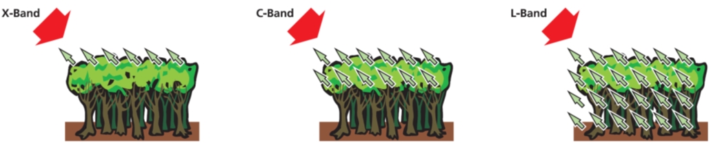
Radar systems can be operated in a wide selection of frequency bands. The choice of band decisively influences the radar imaging and, therefore, the information that can be extracted. Several national and international papers and studies with important participation by German scientists confirm that frequencies in L-band have the greatest potential for applications in the areas of earth and environmental sciences. L-band corresponds to a wavelength of 24 cm, which, in contrast to the shorter wavelengths in C-band and X-band (wavelength 5.6 cm and 3.1 cm), is characterised by a large penetration depth for the volume scatterers, like vegetation, ice, dry soil and sand. Only by using long-wave L-band is it possible to penetrate thick vegetation down to the ground and, therefore, measure its vertical structure. Another decisive advantage of using long wavelength radar signals is the greatly improved temporal coherence, important for the measurement of surface deformation and glacial motion. Thus Tandem-L will allow global motion measurements of the earth’s surface with cm down to mm accuracy over long periods.
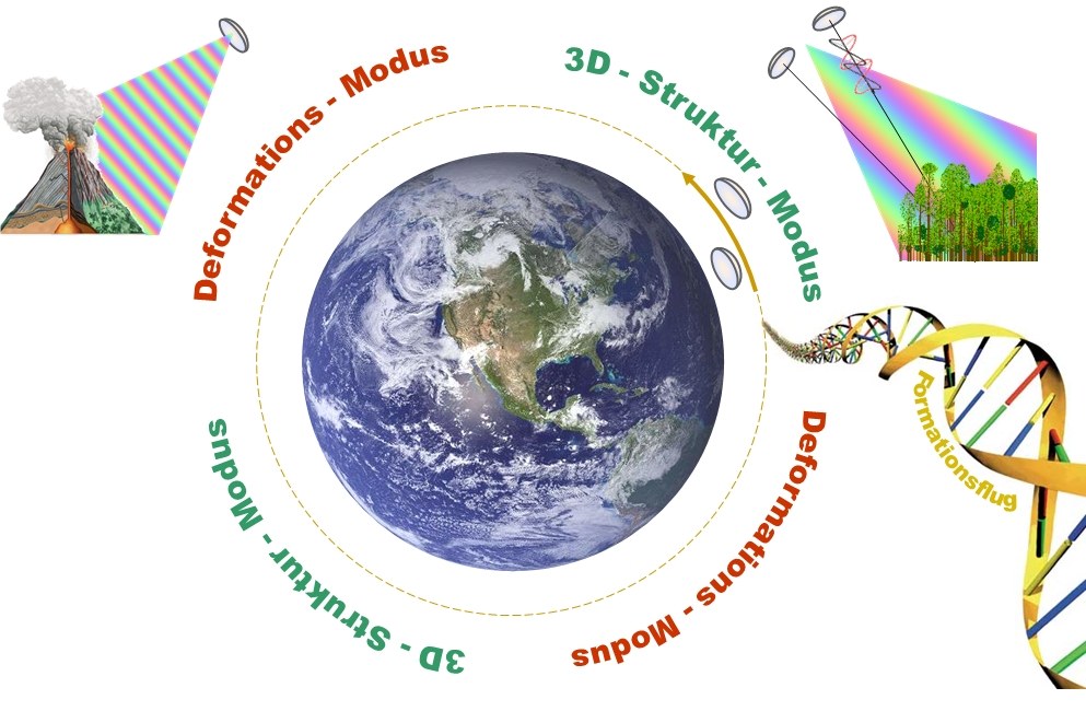
The three-dimensional imaging of the earth’s surface and the tomographic measurement of 3-D structures requires simultaneous imaging from two different look angles. The optimum spacing (baseline) between the two imaging positions varies from approx. 1 km to over 10 km. A variable baseline length in this range is best achieved with a pair of satellites flying in close formation. A tandem formation is not only a fundamental prerequisite for the global measurement of forest height and vertical structures, but is also the basis for a multitude of other applications, as e.g.
Generation of digital elevation models both with and without the influence of vegetation.
Observation of three-dimensional ice structures and their spatiotemporal variations.
Measurement of ocean currents and wave height.
Detection of land and slope instabilities.
Observation of wetlands and water level measurements underneath vegetation.
Determination of sea ice thickness.
Monitoring of dykes. Detection of forest damage.
Monitoring of morphological variations in thawing permafrost regions.
etc.
SAR Instrument
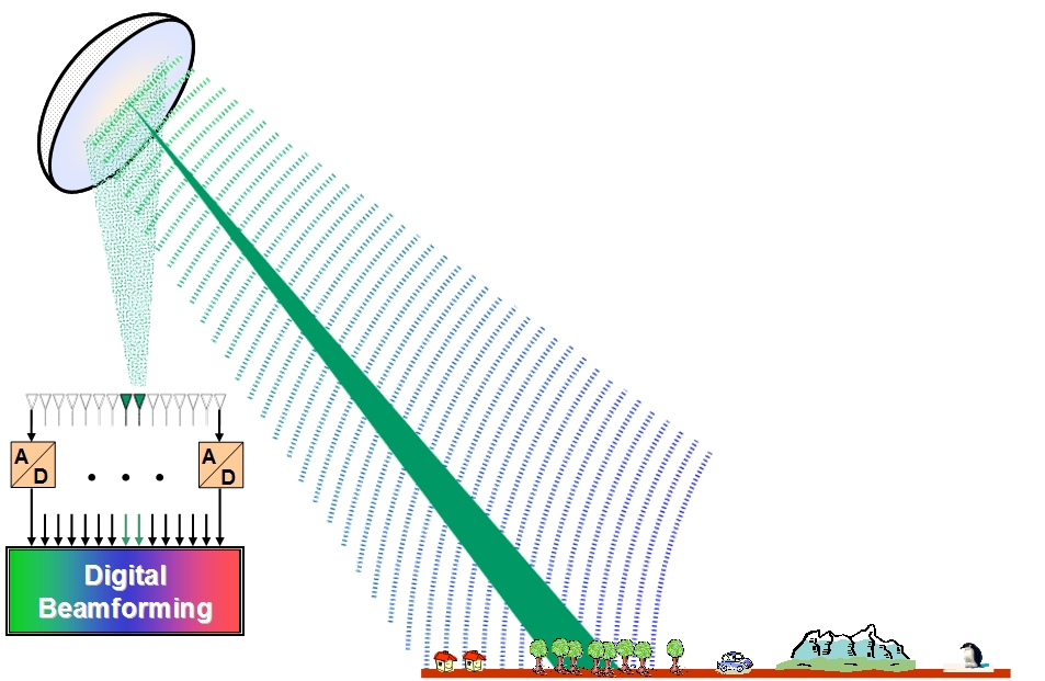
A particular challenge for the Tandem-L mission is the development of two powerful but economic SAR satellites able to meet the user demands. In addition to the innovative mission concept, a new technology for the SAR instruments is needed to meet the requirements for a wide swath, short revisit time, high resolution, and fully polarimetric operation. The decisive innovation with Tandem-L is the use of a large, deployable reflector antenna fed by an array with several parallel digital channels. This technological revolution combines the advantages of digital beam-forming with high sensitivity due to the large aperture area of the deployable reflector, which is huge compared to the aperture of conventional SAR instruments. Digital antenna synthesis using digital beam-forming technology vastly improves the radar imaging flexibility and allows the implementation of extremely powerful operating modes, which can be optimally adjusted to meet the different requirements of the 3-D Structure Mode and the Deformation Mode. For instance, the implementation of the latest SAR operating modes, whereby images are generated in parallel with variable pulse repetition frequencies and several antenna patterns, allows the imaging of extremely large swaths with hitherto unknown spatial resolution without compromising other imaging parameters. In contrast, with conventional radar systems, the resolution worsens proportional to the swath width (or, conversely, the swath width reduces with an improvement in resolution). On top of this, the use of the large reflector increases the sensitivity and allows a considerable reduction in transmit power. In this way, the SAR instruments can be operated quasi-continuously.
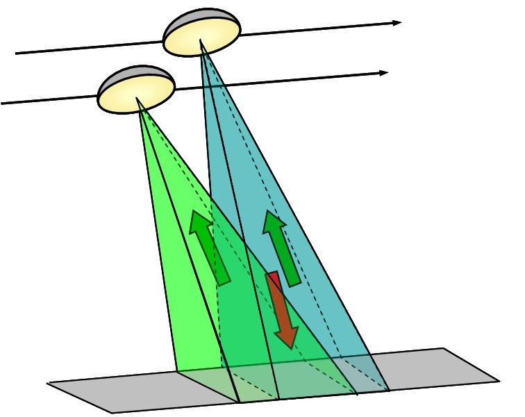
The mission concept is based on two imaging modes, as shown in Figure 32. In the Deformation Mode a strip up to 350 km wide is imaged with a fixed transmit polarisation. In the 3-D Structure Mode the two satellites are operated in a formation whereby they are displaced with respect to the look angle, in order to create an interferometric baseline suitable for the vertical structure measurements. Fully polarimetric operation limits the swath width to approx. 180 km in the high-resolution mode, due to limitations of the internal data rate. Due to this, for complete coverage of 3-D structure measurements at the equator, a minimum revisit time of 16 days is obtained; at higher latitudes the time between images is correspondingly reduced.
Tandem-L mission concept
The Tandem-L mission concept foresees alternating operation in 3-D Structure Mode (right) and Deformation Mode (left). In the Deformation Mode, as broad a swath as possible is imaged with fixed transmit polarisation. In this way, the time between images can be minimized. The 3-D Structure Mode combines single-pass interferometry and fully polarimetric operation, in order to measure vertical structures and their variation using tomography.


