
Scientific Requirements
Biosphere/Forest
For a long time, the role of the forest with respect to climate change was underestimated. Today, we know that forests are an important factor for climate conditions. In modern climate models, the interaction of the forest and the atmosphere, hydrosphere and geosphere play a central role. This is because the forests are predominantly responsible for the carbon exchange between the terrestrial ecosystems and the atmosphere. But forests also influence the albedo of the earth’s surface and, hence, the radiation balance, and are an important factor for the atmospheric water balance. As forests represent climatically extremely well-tuned ecosystems, climate changes have considerable influence on their distribution, the constituent species and the growth. Climatic conditions influence the forest directly through temperature, precipitation and wind, and indirectly through insect and disease infestation. Climate change further increases the pressure on forests.
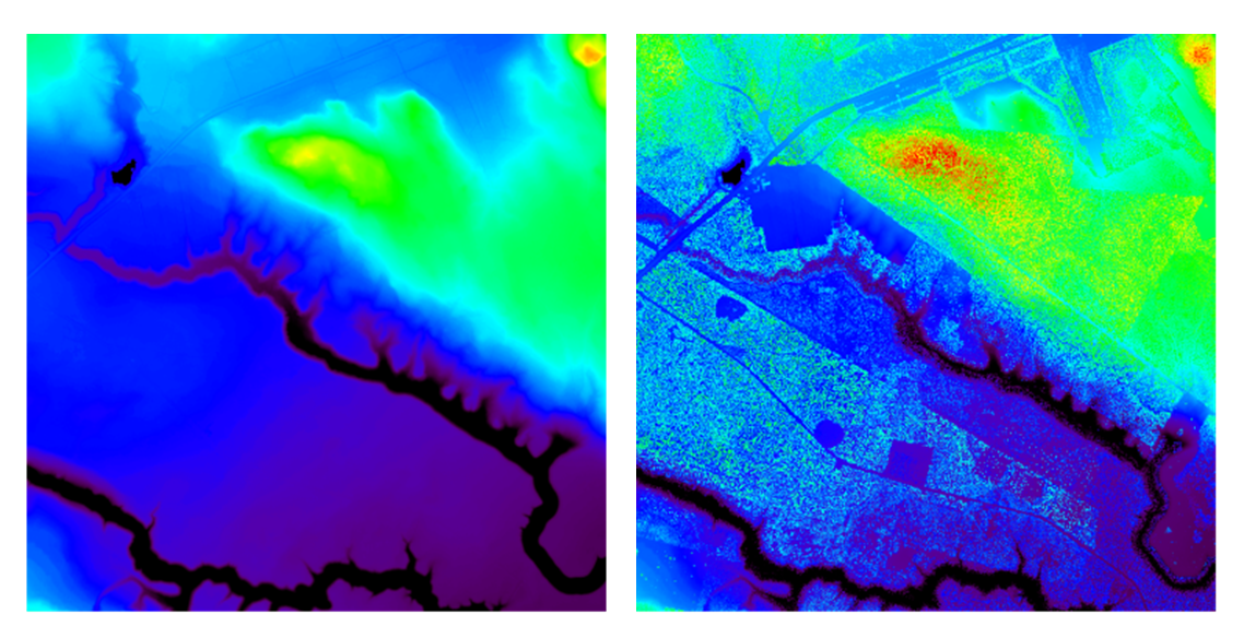
The parameter which characterises the distribution of carbon in the biosphere is biomass. The importance of biomass manifests itself not only due to its role as a carbon sink or carbon source, but also due to its relevance for characterising forest or ecosystem productivity. Dynamic variations in the biomass are a direct measure of the exchange of carbon between the terrestrial ecosystem and the atmosphere. Biomass inventories and biomass dynamics in local, regional and global scales are essential, though, up to now, largely unknown initialisation parameters of current climate models (see Figure 3). A precise determination (~20%) of the spatial distribution of forest biomass would be sufficient to match the inaccuracy of terrestrial carbon fluxes to the other components of the carbon cycle. Biomass was identified by the UNFCCC as an Essential Climate variable (ECV), whose determination is of great importance to reduce the uncertainties in our knowledge of the climate system.

Tandem-L can play a decisive and unique role in achieving a consistent global forest biomass inventory and determining the spatial dynamics of forest biomass. Precise forest biomass determination is based on forest height and structure measurements. It not only facilitates a highly accurate biomass inventory for all critical forest ecosystems, including the tropics, (measurement accuracy <20%, and, therefore, better than achievable with ground measurements) but also the yearly determination of dynamic trends throughout the mission lifetime. Furthermore, the analysis of changes in the vertical forest structure allows an insight into the hardly-known seasonal forest biomass cycle.
Furthermore Tandem-L can serve as a valuable data and information source in areas such as anthropogenic destruction and illegal logging (worldwide biggest threat for forests), biodiversity (e.g. mapping of anthropogenic disturbances), storm damage (forest damage), and reducing emissions from deforestation and forest degradation (REDD).
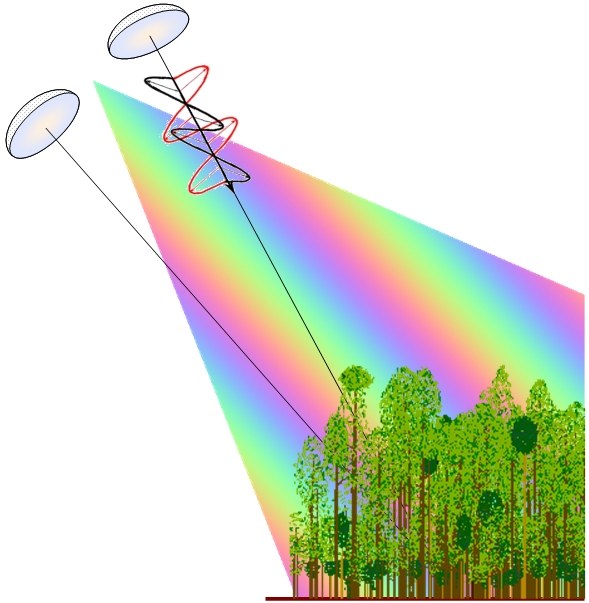

Forest structure, forest heights and biomass are estimated via Polarimetric SAR Interferometry (Pol-InSAR) applied to Tandem-L data. Pol-InSAR is based on the coherent combination of SAR interferograms for different polarisations. On the one hand, SAR interferograms are sensitive to the spatial diversity of the vegetation’s vertical structure and allow precise measurement of the scattering centre. On the other, the polarimetric radar signature is sensitive to the shape, orientation and dielectric properties of the scatterers and facilitates the identification and/or separation of scattering mechanisms in natural media. With polarimetric SAR interferometry, the complementary sensitivities of these two measurements are combined coherently, allowing the quantitative determination of relevant (structure) parameters from SAR measurements. Today, Pol-InSAR is an established technique, allowing investigation of the 3-D structure of natural volume scatterers.

Geo-/Lithosphere
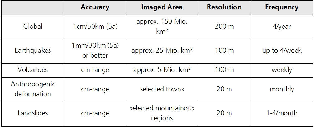
Earthquakes belong to the most cataclysmic and expensive georisks; according to a calculation by the reinsurance company “Munich Re”, between 1994 and 2006 alone, they cost more than 240 billion US$. In urban areas like Tokyo, a single, strong future earthquake could cause damage of 1000 to 2000 billion US$. Earthquakes are caused by dynamic processes of the earth’s crust: plate tectonics and small scale magmatic, climatic and anthropogenic processes change the crust continuously. Although in the years from 2010 to 2012, the TanDEM-X mission will take a very accurate snapshot of the earth’s 3-D topography, it is not suitable for a regular, global long-term survey, due to the very short wavelength and the small coverage. However, operating in the Deformation Mode, the Tandem-L mission will constantly monitor the global topographic changes with accuracies from centimetres down to millimetres. Furthermore, thanks to the large-area deformation measurements (i.e. not just selected point measurements with permanent GPS stations), geophysical models can be developed much more precisely and, hence, provide insight into the underlying processes in the earth’s crust.
DThe deformation measurement method is based on repeat-pass interferometry, also known as differential SAR interferometry. This technique measures small range changes of the earth’s surface derived from the microwave phase difference of two SAR images, recorded with a time difference from days to several years. The accuracy of the individual measurements is a fraction of the wavelength. By appropriate computation of data from long time series, very small deformation rates of millimetres per year can be derived. High accuracy is also needed to observe the very slow changes in the earth’s surface that occur in areas susceptible to plate tectonics or volcanic activity.
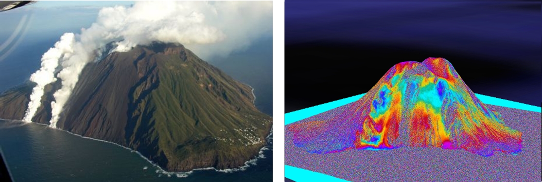
In a similar way to earthquakes, volcanoes endanger life and property. Thanks to the small-area processes, science today can predict volcanic eruptions better than earthquakes. At the present time, localised gas-spectrometer, thermal and seismic measurements are used for volcano observation. However, in recent years, geometric surveying of the surface by means of satellite-based SAR interferometry is increasingly employed. It is a goal of the Tandem-L mission to observe all the world’s large volcanoes (approx. 500) once a week from different imaging geometries, to process the data systematically and to prepare these for use as initiating parameters for three-dimensional, elasto-mechanical volcano models. Unusual events will be promptly detected during processing and immediately used for early warning.

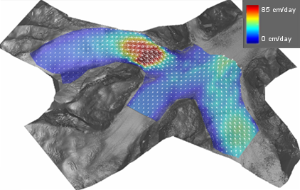
Further applications of Tandem-L are anthropogenic earth motions (e.g. due to mining, pumping of oil, gas or water) and slope movements/landslides in dedicated areas.

Cryosphere
The snow and ice masses on the earth (the cryosphere) play an important role in the earth’s climate system, due to feedback mechanisms of the atmosphere and the oceans. These mechanisms have the tendency to intensify climate changes. However, the processes regulating the dynamics and mass balance of the individual components of the cryosphere are not yet sufficiently understood. For this reason, the coupling of cryospheric processes is a weak point of current climate models and an important reason for the uncertainties in climate predictions and climate scenarios. From improved, systematic observation data, large advances in developing earth system models which take the cryosphere into consideration are expected. Apart from affecting the atmosphere and the oceans, changes in the cryosphere due to climate change also directly influence the environment, ecology and commerce. Falling water resources due to shrinking winter snow and glaciers, harms the water supply, agriculture and biodiversity. All over the world, coastal regions are threatened by the thawing of glaciers and the polar ice masses. The melting of the arctic sea-ice cover, which is proceeding much faster than predicted, is creating new geopolitical and ecological realities at high northern latitudes.

- Precise data on the mass balance of the ice sheets and glaciers, and their contribution to sea level increase.
- Improved parameterisation of the flow dynamics of ice streams and glaciers.
- Quantification of the dynamics and thermodynamics of sea ice.
- Improved understanding of processes close to the surface in permafrost zones.
- Mapping of the water reserves in winter snow cover.
Hydrosphäre
The hydrosphere is part of the geosphere and encompasses the above-ground and subterranean water reserves. Seen from space, the earth is a blue planet, illustrating the large area of water: three quarters of the earth’s surface is covered by water. The water cycle and the climate are closely correlated and mutually dependent. Scenarios of the future climate show numerous uncertainties, particularly with regard to variations in the water cycle. The global warming of almost 0.8°C over the last 100 years should result in an intensification of the water cycle. Almost all climate models show that an increase of temperature at the surface by 1°C causes an increase in precipitation by 2-3%, due to the increased evaporation, particularly over the oceans. Warming of 1°C will, theoretically, raise the water vapour capacity of the atmosphere by 7%. In general, it is assumed that the hydrological cycle will be intensified by global warming, due to greenhouse gases.
However, it is very difficult to confirm such a tendency. This has two principal reasons. Firstly, precipitation and evaporation strongly vary from place to place, and sufficiently precise time series of data only exist for a few regions. On the other hand, in recent decades, not only has the concentration of greenhouse gases in the atmosphere increased, but also that of aerosols, which lead to cooling and a fall in precipitation. According to recent model computations, the hydrological cycle can react stronger to changes in the aerosol concentration as to changes in the concentration of greenhouse gases. Since aerosols have a short lifetime in the atmosphere, their influence on the areas where they are created is limited. The global effect on the hydrological cycle is, therefore, relatively unclear. In the period 1951-2005, there is no clear global trend for precipitation over land. However, regional trends are often clearly visible.
Another climate change effect very probably coming our way is already making itself evident, i.e. the accelerated thawing of snow, ice and glaciers that act as natural water reservoirs, and the increase in rain and decrease in snowfall with increasing temperatures. This leads to increased run-off in winter and early spring and leaves less water available for summer and the dry season, when the need is the greatest. While it has to be assumed that precipitation will increase globally with higher temperatures, in drier regions it can get even drier, due to reduced precipitation, changes in the rainy seasons and higher evapotranspiration. The relationship between changes in precipitation into water availability is non-linear. Small falls in precipitation can be amplified in the hydrological system leading to considerably larger reductions in ground water production with possible consequences for the water quality, if the withdrawal of ground water increases simultaneously. Falling ground water levels in coastal regions often lead to saltwater intrusion that can render the water useless. The increase in sea levels as a consequence of global change further accelerates this process.
With the intensification of the water cycle due to warming, one has to expect more frequent and severe extreme events, even if observations don’t generally confirm this trend.
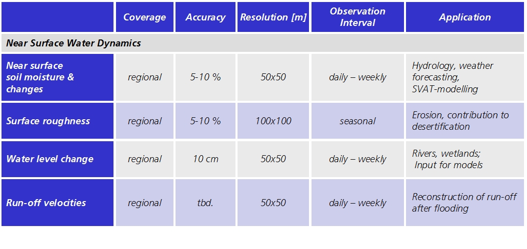
In order to understand the influence of the climate and man-made incursions on the water cycle better, it is necessary to have knowledge of the components of the hydrosphere, in order to determine the current status and the variability. Particularly important are the parameters, near-surface soil moisture and surface roughness, as well as the water levels in rivers and wetlands together with the river flow speeds.
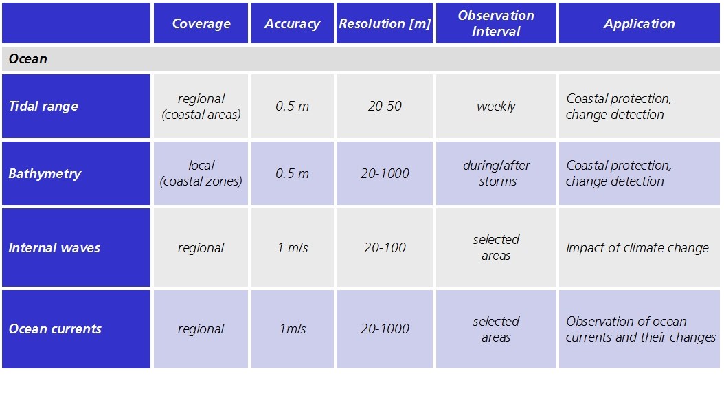
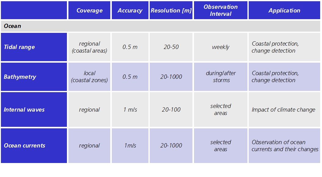
Further applications of Tandem-L for the investigation of processes in the hydrosphere, particularly also in the area of oceanography, are:
- Water level changes and flow speeds.
- Tidal range and bathymetry (shipping and coastal protection).
- Internal waves.
- Ocean currects (transport of large water masses).

Globales DEM
For parts of the earth, only coarse, inconsistent or incomplete elevation models exist, which have been put together from numerous different data sources using different surveying methods. TanDEM-X will close these gaps and generate a global, homogeneous elevation model, as an indispensable basis for numerous scientific and commercial applications. The TanDEM-X DEM is specified to achieve a spatial resolution of 12 m x 12 m and a vertical accuracy of 2 m. For data acquisition, TanDEM-X employs an interferometric radar system in X-band, which only penetrates vegetation to a small amount, due to the short wavelength of 3.1 cm. Hence, TanDEM-X delivers a digital elevation model of the surface of the earth, i.e. the upper surface of strongly vegetated areas (forest) and of urban areas (roof surfaces). In contrast, a digital elevation model describes the topographic variation under the vegetation. With a wavelength of 23.6 cm, Tandem-L penetrates vegetation and, using polarimetric SAR interferometry, can not only measure the surface topography, but also the topography under the vegetation. Hence, Tandem-L will complement TanDEM-X to provide additional information on the earth’s topography.
TanDEM-X will complete the global digital elevation model in 2014. Assuming Tandem-L is launched in 2019, the first digital elevation and surface models can be made available in 2020. They will therefore be ideal extensions to the surface model from the TanDEM-X mission. During the mission lifetime of Tandem-L, it will also be able to provide regular updates of the TanDEM-X DEMs.

Digital elevation models are of fundamental importance for a broad spectrum of commercial and scientific applications (geoscience research, hydrology, glaciology, geology, permafrost, environmental science etc.).The Tandem-L science team has formulated the requirements for the spatial resolution of a digital elevation model as 50 m x 50 m with a relative vertical accuracy of ~4 m. With this resolution, the global digital elevation model will be unique, and the basis for a homogeneous set of maps that can only be achieved with Tandem-L.