
Technical Concept
Space Segment
The space segment consists of the satellite, comprising the SAR instrument for performing the radar measurements, and the satellite bus, comprising the units for attitude control, power supply, star camera, GPS receiver, data transmission etc, necessary for the functioning of the satellite. With few exceptions, the Tandem-L space segment utilises a standard bus configuration, while the SAR instrument has the highest degree of innovation.
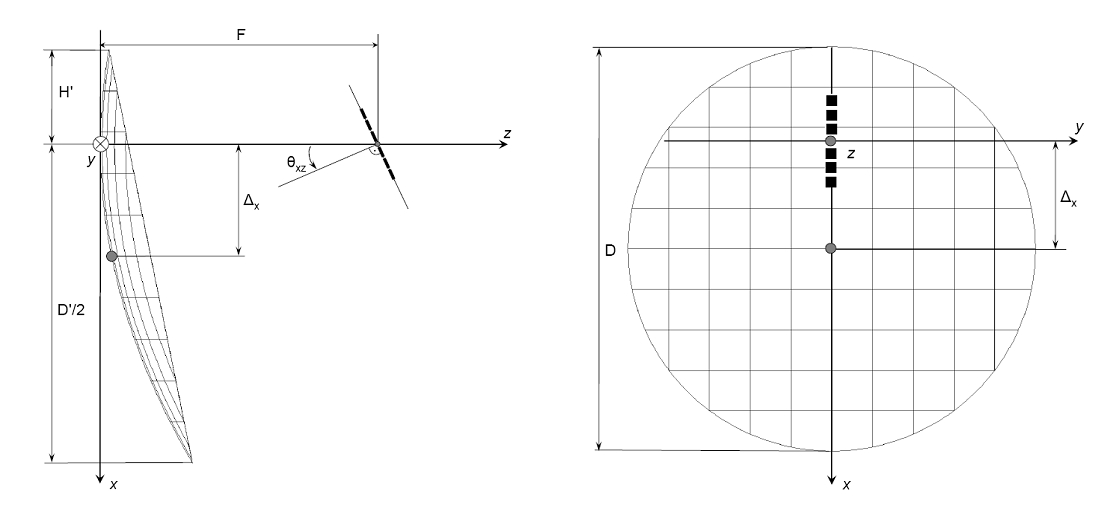
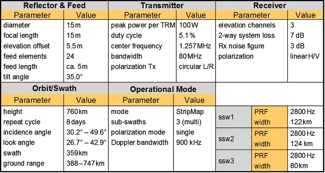
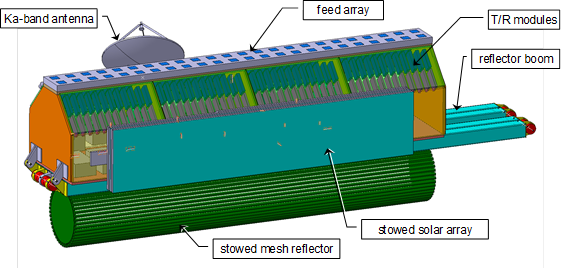
The Tandem-L antenna comprises a deployable reflector illuminated by a digital feed. The advantage of the reflector lies in the large available antenna aperture area for a low cost per square metre. With a diameter of 15 m, the gain on receive is equivalent to that of a planar antenna with an area of 175 m2, which is not realisable. The reflector is illuminated by 24 x 2 (elevation x azimuth) dual-polarised, aperture coupled patch elements. For each polarisation, pairs of azimuth elements are combined via a strip-line network. Each of the signals of the 48 channels is amplified and digitised directly at the carrier frequency. Hence, there are 24 data streams per polarisation.

The narrow antenna beam, due to the summation of the signals from the feed elements, illuminates only a small area of the reflector, producing a broad antenna beam for illuminating a total swath width of 350 km or 180 km. On receive, the signal reflected from the ground illuminates the whole of the reflector and is then focused on a limited area of the feed array. The intersection of the spherical wave of the radar pulse with the earth’s surface is a strip in the shape of a partial ellipse.
A feature of Tandem-L is the multi-channel structure and the resulting extremely high internal data rate. An innovative modular bus and processing concept developed by German industry has the task of transferring and combining the individual data streams.

The Tandem-L platform architecture makes use of the innovative concept of a compact bus. The particular feature is the feed array being integrated with the satellite bus and housed in a single mechanical structure. Apart from the advantage of a compact overall structure, the compact bus facilitates a one-dimensional deployment mechanism with a minimum number of hinges. The accommodation of both Tandem-L satellites into a FALCON-9 launcher is possible. The dry mass of one satellite is approx. 1600 kg; the FALCON-9 launcher shall be able to transport a payload of 6800 kg into the chosen orbit.

Bodensegment
The ground segment comprises all the elements needed for the routine operation of the Tandem-L mission apart from the satellites themselves; i.e. all functions from mission planning and satellite control, via the commanding of the instrument and data reception to the processing and distribution of the products. Novel aspects for an imaging mission are the enormous data volumes and the strong focus on well-defined scientific goals. Both aspects require an innovative concept for efficient exploitation of the data. Therefore, as a rule, not the image data will be given to users, but highly-aggregated products of the required geophysical parameters. For this reason, the expertise of the relevant HGF research centres with their specific modelling expertise will be drawn upon.
Particular high demands to the Tandem-L mission incur in the areas of formation flying (highly accurate flight in an orbital tube of 100-250 m), mission planning and commanding (merging oft wo contradictory operation modes), data transmission to the ground (at least 2 Terabyte per day), long-term archiving and data processing.
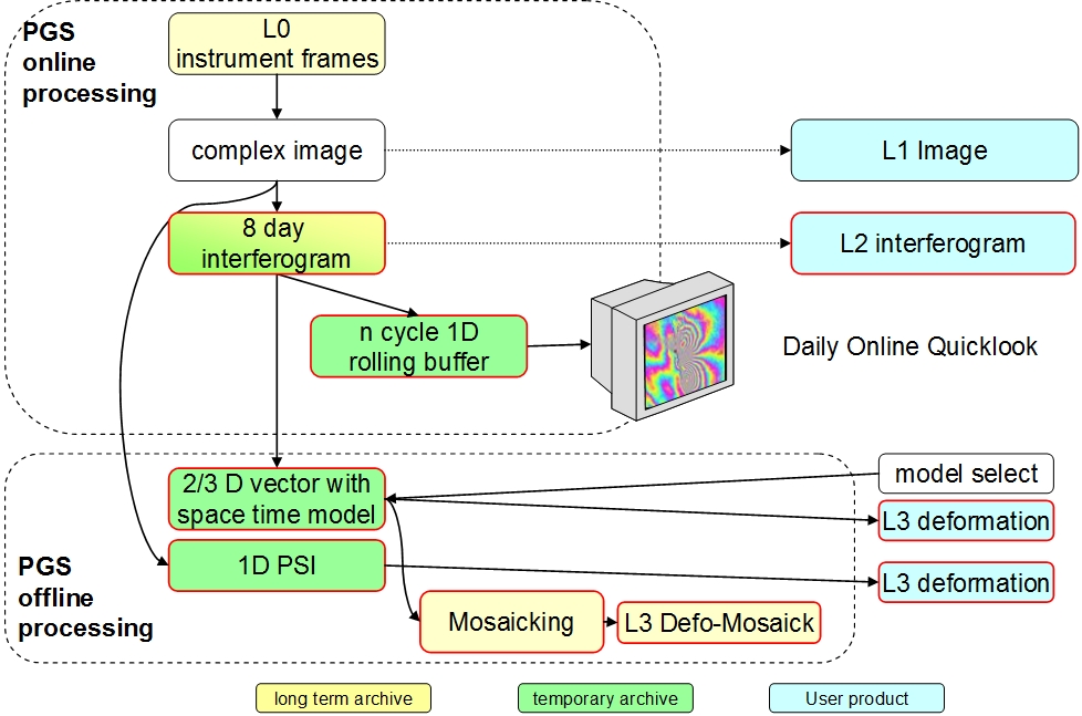
For processing the data, both purely quantitative and conceptual challenges coincide. A first calculation shows that a data volume of approx. 2 to 5 terabyte/day can be handled by approx. 90 computers, of the type presently used for TanDEM-X. The scientific community would be overburdened with this quantity of raw data. In order to achieve the scientific goals and to guarantee a lasting benefit for society, this volume of data has to be reduced to the relevant information. On the one hand, to this end, thematic on-line processing will be performed at DLR in step with the data acquisitions and will provide daily deformation maps, similar to the procedure at weather centres today. To keep the computation time within limits, these maps will not have the highest precision. They can, however, serve as a first indication for early warning. On the other hand, high quality and quality-controlled products with documented quality parameters will be provided to scientific users on order (i.e. off-line). Depending on the type of user, sensor-oriented products (e.g. SAR images), intermediate products (e.g. interferograms) or geo-information products (e.g. 3-D deformation maps) can be produced. In the case of the higher-value information products, the processing parameters are selectable, e.g. the requested time period for interferometric processing.

