
SAR Missions
The group “SAR Missions“ develops and elaborates proposals for future SAR missions. The user requirements are analyzed and appropriate mission concepts are derived. The definition of the mission and product parameters requires detailed investigations regarding performance, coverage, revisit times, orbit geometry, etc. Implementation trade-offs are analysed and the mission design is optimized by developing global performance models. The new mission concepts will also employ advanced SAR imaging techniques and technologies like multi-channel receiver systems, digital beamforming, and multistatic satellite formations. The mostly theoretical work is complemented by proof-of-concept experiments of novel acquisition techniques using TerraSAR-X and TanDEM-X.
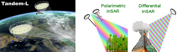
Mission Proposal: Tandem-L
Tandem-L is a proposal for an L-band Polarimetric and Interferometric SAR mission to monitor Earth’s dynamics with unprecedented accuracy and resolution. A wide spectrum of scientific mission objectives is covered, including producing a global inventory of forest height and biomass, large scale measurements of the Earth deformation, systematic observation of glacial motion, soil moisture and ocean surface currents. Tandem-L foresees the deployment of two spacecraft flying in close formation similarly to the TanDEM-X mission. The instrument will feature many technical innovations, such as the combined use of a reflector antenna and digital beamforming techniques on receive to achieve large swath coverage, high sensitivity and ambiguity rejection at the same time.

Mission Concept
The mission concept is based on two main operation modes:
- A 3-D structure mode, which employs single-pass bistatic interferometry in a fully polarimetric configuration. Such an acquisition mode, with repeated takes, will allow the reconstruction of vertical profiles in a quasi-tomographic sense, and is aimed at semitransparent media like vegetation, sand and ice.
- A deformation mode, which requires long series of acquisitions with short repeat-pass intervals, and is aimed at detecting millimetric surface deformations due to tectonics, ice flows, subsidence, landslides, etc.
The generation of suitable baselines (several kilometres are needed at L-band) would be very expensive by direct out-of-plane manoeuvres to control the orbital plane separation. Instead small inclination differences will be imposed, which will cause continuous drifts of the ascending nodes thanks to well-known Earth gravitational inhomogeneities. In this way large baselines can be accumulated over long time intervals with limited fuel consumption.
The Tandem-L study has been conducted in close cooperation with NASA/JPL (DESDynI).
Mission Concept Example: SIGNAL
The SIGNAL (SAR for Ice, Glacier aNd globAL Dynamics) mission concept was developed, prepared and proposed as a candidate for the 8th Earth Explorer Opportunity Mission. The study was supported by the German Space Administration. SIGNAL is an innovative Ka-band SAR mission concept with the main objective to estimate accurately and repeatedly topography and topographic changes associated with mass change or other dynamic effects on glaciers, ice caps and polar ice sheets. Elevation measurements are complemented with glacier velocity measurements, providing valuable additional information for a better understanding of the hydrology of glacierized basins and of the Arctic and Antarctic water cycle.
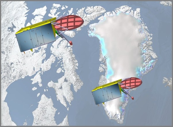
The driver for the mission design is the generation of digital elevation models of all relevant areas with height accuracies in the order of a few decimetres. This goal justifies two fundamental choices: the use of Ka-band (35 GHz) to minimize the penetration into the ice or snow cover, in order to obtain a DEM that is truly representative of the surface; and the use of a pair of formation flying satellites, which is the only way to obtain the long baselines required to achieve the desired height sensitivity and measurement stability, avoiding temporal decorrelation effects. SIGNAL is planned as a systematic mapping mission with full coverage of latitudes above 60° North and below 60° South every two months and with a lifetime of at least 5 years, generating seasonal DEMs of the areas of interest.
SAR System Description
In order to provide the required SAR performance in terms of data sensitivity, ambiguity rejection, and coverage, a reflector based system architecture is proposed that uses SCan On REceive (SCORE) in order to obtain a sufficiently wide swath despite the narrow, high-gain, receive beam. The total coverage is further increased by simultaneously acquiring two sub-swathes separated by a gap approximately twice the width of a single sub-swath (~ 25 km).
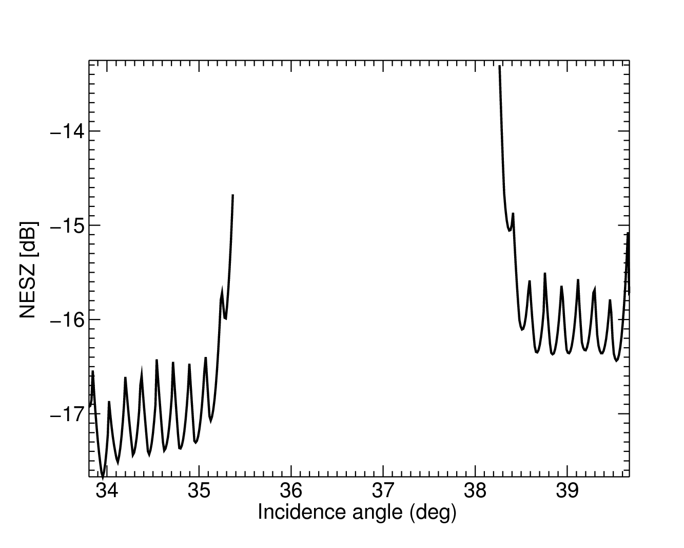
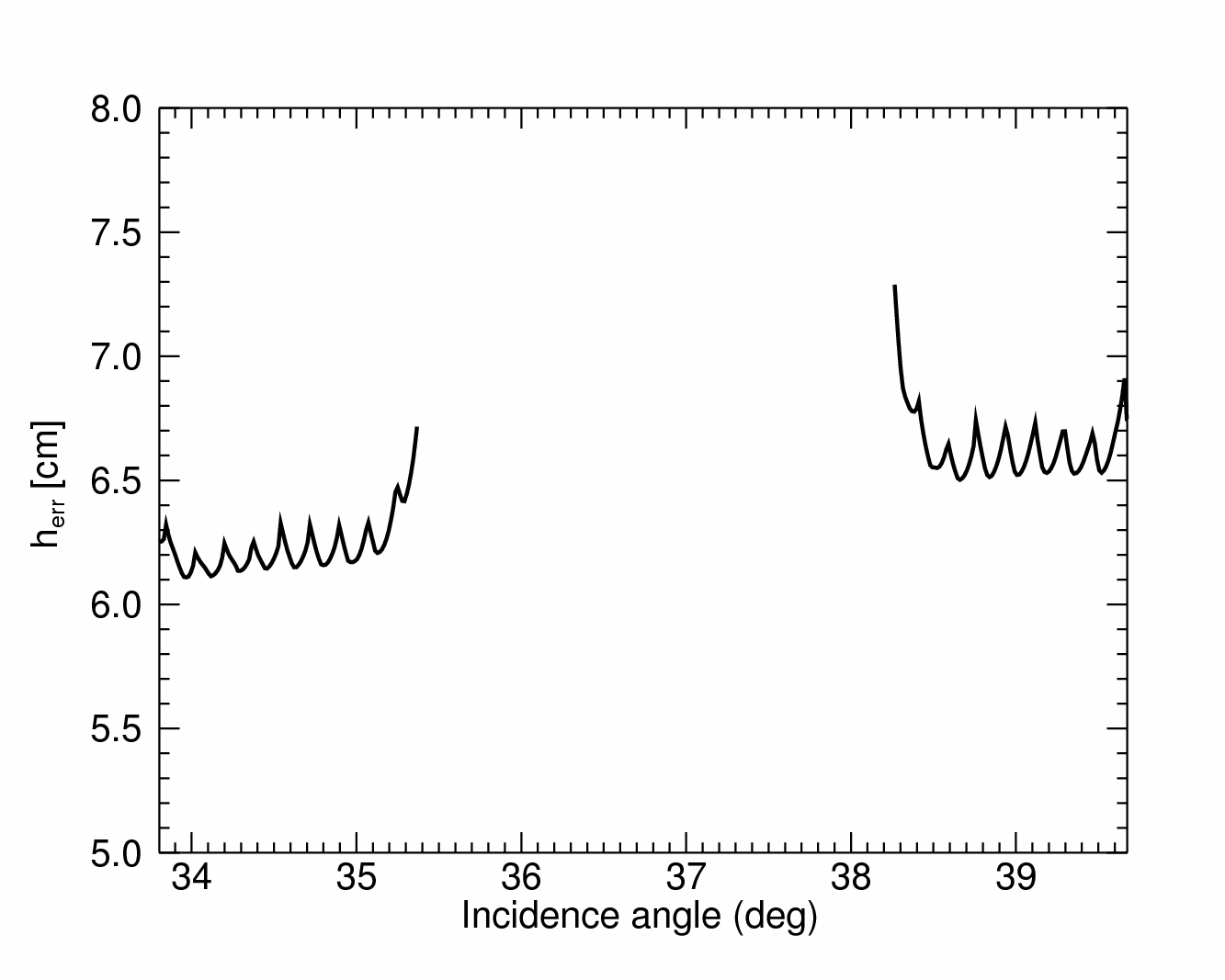
Interferometric Performance
In order to meet the science and user requirements, SIGNAL needs to achieve point-to-point relative height errors in the order of a few decimeters, which is an order of magnitude better than TanDEM-X. The two keys to meeting these highly demanding requirements are the very large number of available looks and large, relative to the wavelength, interferometric baseline.
Experiments with TerraSAR-X and TanDEM-X
The SAR-Mission group is involved in or in charge of many experiments using TerraSAR-X and TanDEM-X. The flexible commanding capability of both SAR instruments is unique among the currently available space-borne SAR systems. The experiments are performed in order to exploit these capabilities. The results can have an important influence on the design of future space-borne SAR Missions as well as on the improvement of current SAR systems. In particular the focus concentrates on new SAR imaging modes and experimental SAR geometric configurations. New applications can be the results as well as the refinement of techniques for existing applications.
In order to perform the experiments the group has to deal with TerraSAR-X/TanDEM-X as an end-to-end SAR system, i.e. from SAR commanding to SAR data processing. Therefore the group is working closely together with many other groups in the institute, either supporting them in their experimental activities as well as receiving support and benefit from the huge knowledge base of the institute.
Crossing Orbit Interferometry – First TanDEM-X Digital Elevation Model
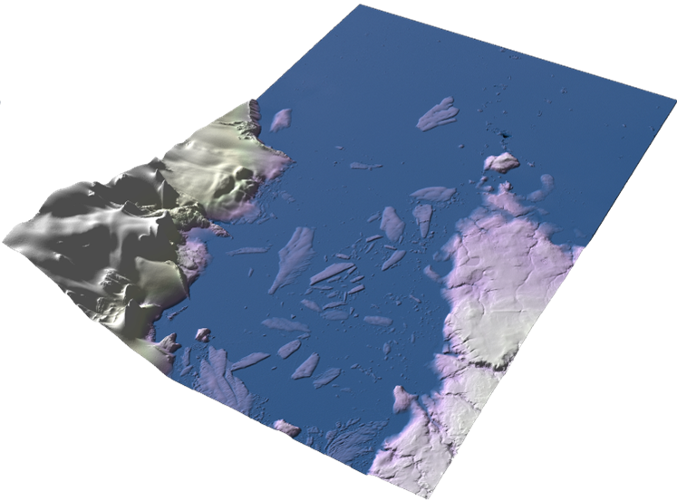
Typical space-borne along-track SAR interferometry considers almost parallel orbit tracks in order to obtain coherent interferograms. For differential interferometry this requires a full orbit cycle time difference, i.e. 11 days in case of TerraSAR-X and TanDEM-X. In a novel satellite geometry constellation under crossing orbits it is possible to obtain coherence even after less number of days. This offers e.g. promising short-term monitoring of glaciers and ice shelves in X-Band, which was not possible before. Using this method it was possible during the Commissioning Phase of TanDEM-X to acquire a very high precision Digital Elevation Model of the October Revolution Island, Russia, with a relative height error of approximately 10 cm.
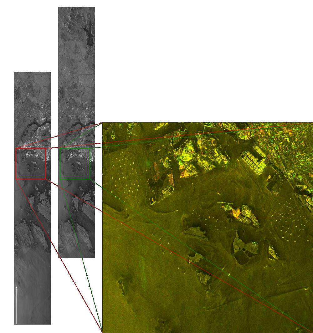
Bi-directional SAR
Bi-directional SAR is a new imaging mode which offers the possibility to image areas in two directions simultaneously. This results in an imaging of the same area with a very short separation in the order of seconds. In combination with interferometric acquisitions, many change and motion detection applications are possible.
TOPS imaging mode demonstration - Terrain Observation with Progressive Scan
The first space-borne demonstration of the TOPS imaging mode was performed with TerraSAR-X by the Microwaves and Radar Institute. It is a wide swath imaging mode which overcomes disadvantages of the ScanSAR mode, like scalloping. The group involved in many TOPS activities. Mainly it is responsible for the TOPS commanding generation but also supporting and evaluating performance and processing studies.
An interferometric subsidence study on Mexico City with a time series of TOPS acquisitions was performed by the Multimodal Algorithm Group:

Current Projects
The group is involved in several projects:
- BIOMASS End-to-End Simulator: coordination of the development and implementation of several main components of and end-to-end mission performance simulator for ESA’s Earth Explorer candidate mission BIOMASS.
- Ka-Band SAR: the group participates in a ESA study to develop a Ka-band single-pass interferometric system and mission concept. The short wavelength allows using a relatively short boom to obtain the required interferometric baseline.
- Tandem-L: the group is responsible of studying mission related aspects (mission planning, end-to-end performance, etc) related to the Tandem-L mission concept.
- TOPS Studies: the group supports diverse TOPS studies, being responsible for the acquisition of experimental TOPS data.
- TRAMPA (Toolbox for Radar Mission Performance Analysis): development of a set of generic tools for mission performance analysis (orbital analysis, mission coverage, product performance, etc.).