
Team: Hyperspectral Remote Sensing
The “Hyperspectral Remote Sensing” team provides methods and products for optical imaging sensors on satellites and aircrafts.
In the area of spaceborne missions, operational fully-automated systems for processing image data are developed for ground segments. Currently, these processing chains are applied for the German hyperspectral mission EnMAP (Environmental Mapping and Analysis Program) and for the American-German hyperspectral mission DESIS (DLR Earth Sensing Imaging Spectrometer) , installed on the ISS (International Space Station). The processing of these image data thereby includes the:
- Conversion of the data into physical measurements. For this purpose, in addition to the processors, the necessary spectral and radiometric calibrations are evaluated based on the satellite equipment, but essential properties from the remote sensing data itself are also analyzed for quality control.
- Georeferencing and orthorectification of the image data. These are thereby mapped from sensor geometry without distortion into map projections. Based on the developed software ORTHO, robust geolocation enhancement techniques based on reference images are also considered for this purpose.
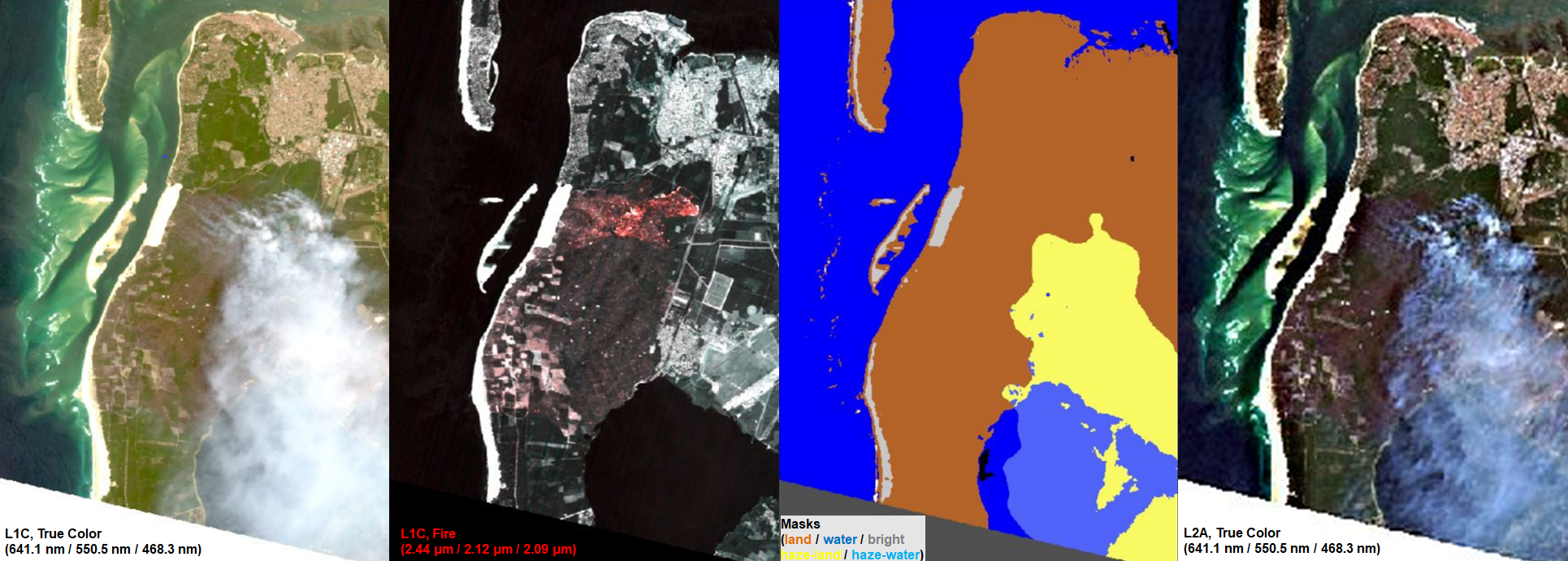
- Compensation of atmospheric effects based on the developed software PACO (Python-based Atmospheric COrrection), which processes a variety of sensor data in the VIS/NIR and SWIR spectral ranges and also includes a classification of, for example, clouds, the precise derivation of the necessary atmospheric parameters such as aerosol and water vapor content for consideration in radiative transfer, and a correction of cirrus.
The standardized products created in this process form the basis for deriving higher-level products for a wide range of applications. For this purpose, the team develops the following methods for multi- and hyperspectral images and time series of images, for example:
- Basic algorithms for the differentiation of (green and dry) vegetation and bare soils. This provides valuable information on, for example, erosion risks.
- Algorithms for monitoring cultural heritage and other archaeological sites.
- Algorithms for creating global fluorescence maps.
Further projects continue to develop these and other methods for various future optical missions for Earth surface observation.
A process chain comparable to EnMAP and DESIS is used in CATENA for the airborne mission HySpex
Further projects continue to develop these and other methods for various future optical missions for Earth surface observation.

Fire over Arcachon, France. Subset of an EnMAP image acquired at July 19, 2022, in true color before (L1C, True Color) and after (L2A, True Color) atmospheric correction with masking (Masks), and a plot of spectral bands used to identify the fires (L1C, Fire). EnMAP data © DLR 2022. All rights reserved.