
Modeling and retrieval

Remote sensing means contact-free measurement of the object in question. Over large distances, such as from a satellite which observes the earth from space, a large number of geophysical and biophysical parameters of the earth system can be monitored today with this technology. The physical basis is the interaction of electromagnetic radiation with the surface of the earth and the gases and particles in the atmosphere. Satellites have been increasingly used since the early 1970s as platforms for a wide variety of earth observation instruments, the choice depending on the particular topics being investigated. Different wavelength ranges of the electromagnetic spectrum are required depending on whether, for example, vegetation, cloud distribution, or atmospheric gases are to be monitored, or whether ocean surface temperatures are to be recorded, and the measuring instruments are designed accordingly. Thus the light visible to the human eye (ca. 0.4 micrometers (violet) – 0.7 micrometers (red) is frequently used to analyze global weather events, whereas measurements using shortwave ultraviolet and longwave infrared spectra are commonly used to monitor atmospheric trace substances. Much longer wavelengths, from about 3 to 25 centimeters, are used to scan such targets as the relief of the earth’s surface.
The atmosphere as the link between the surface of the earth and outer space is particularly important for monitoring and forecasting climate change. The atmosphere’s multitude of different types of gaseous, liquid and solid substances form a complex mesh of phase transitions, radiation and scatter phenomena, and dynamic as well as chemical processes, all of which not only interconnect and influence each other, but also interact both with the surface of the earth and with outer space. Our ability to look down at ourselves from the vantage point of space gives us invaluable overviews and insights about the atmosphere. Earth observation with satellites makes it possible to monitor this system in an integral way, integral in the sense of comprehensive, simultaneous, validated and uniformly precise measurements of a variety of geophysical parameters over a long time period and for large areas globally. The alternatives of case studies and sampling are both temporally and spatially inadequate because of the great variability of the atmosphere; they do not allow distinctions to be drawn between a climate trend and an isolated episode.
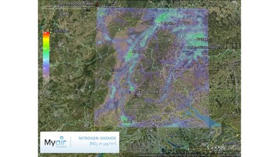
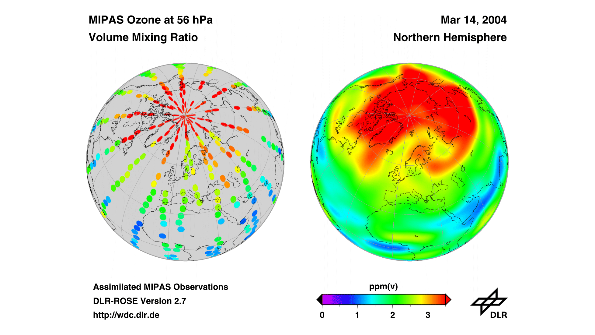
But satellites cannot do the whole job. Complex measuring instruments are designed to record relatively few geophysical parameters. For example, the European GOME instrument on board MetOp satellites measures atmospheric ozone, but provides only limited information about the many other trace gases necessary for understanding ozone chemistry. Also, monitoring satellites fly over the same location on earth almost always at the same time of day. Variations over the course of a day, which are important for monitoring air pollution, for example, cannot be detected with such an approach. Satellite observations on their own deliver a volume of data that is extremely difficult to interpret: every pixel is recorded at a different time and from a different location. This situation is described as asynoptic measurement coverage. In order to obtain synoptic coverage from this very heterogeneous distribution of data patterns for an ozone column measurement, for example, to determine the global distribution of chloride nitrate over wide areas at any point in time and at any altitude, the satellite data is entered into a numerical computer model which reflects current understanding of physical and chemical atmospheric processes. The model then provides a basis for conclusions about the status of trace gas A if that of trace gas B is known. This process is known as data assimilation.
Combining measurement data and models now makes it possible to derive a great amount of information and contributes to understanding the processes of the Earth System. This understanding is in turn the precondition for making reliable forecasts, in other words, for estimating the expected development, such as of the atmosphere, if particular Earth System variables (for example, air pollution) change.
These examples illustrate how information can be gained from combining satellite measurements with models and how this helps to increase our knowledge of processes going on in the Earth System.
