
TerraSAR-X Background Mission Antarctica


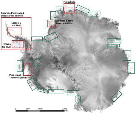
The mission goals for the areas of interest relating to Antarctic ice shelves are to detect fine scaled ice shelf structures, map deformation patterns and ice shelf velocities, and to improve our understanding of ice mechanics and physics. Identifying changes in ice shelf dynamics and classifying the underlying causes are prerequisite activities for evaluating and verifying empirical flow laws, which make it possible to better identify critical parameters and improve predictions of ice shelf stability. The ice shelves selected for study are the Wilkins Ice Shelf, Fimbulisen, Brunt Ice Shelf / Stancomb-Wills Ice Tongue System, Larsen-C, Pine Island, and Thwaites Glacier.
Furthermore, the Antarctic Peninsula and Sub-Antarctic Islands are also being mapped with the goals to improve current estimates of sea level rise as well as to gain a better understanding of the glacier systems. The resulting activities and data products relate to the temporal variability of ice dynamics, changes in glacier extent and terminal position, detection of surface structures and melt patterns on glaciers, as well as mapping of snow cover extent and dynamics on ice-free areas. An extraordinary warming trend has been observed in the region since the 1950s up until recent years, and considerable changes in the glacial systems have been reported, including the break-up and disintegration of ice shelves with subsequent speed-up, land surface lowering, and sea level rise caused by the contribution of tributary glaciers. Furthermore, tidewater glaciers show considerable retreat, surface lowering, as well as the respective dynamic adjustments.
Postulating the consequences of this warming requires frequent and high-resolution monitoring to allow quantification of the underlying processes. The target areas are South Georgia / South Orkney Islands, King George Island, major outlet glaciers on the west coast of the Antarctic Peninsula, tributaries of already disintegrated ice shelves (Larsen-A, Larsen-B and Wordie), tributaries of Wilkins and George VI ice shelves, and tributaries of Larsen-C/D ice shelf and selected areas on the east coast of the Antarctic Peninsula.
During the austral summers 2008/09 and 2009/10 major parts of the proposed study areas were mapped with DLR's TerraSAR-X satellite in StripMap mode (3 m resolution). There was additional systematic acquisition during the Wilkins Ice Shelf break-ups in 2008 and 2009, and subsequent monitoring is currently being accomplished with TerraSAR-X StripMap mode imagery (Humbert and Braun, 2008; Braun and Humbert, 2009; Braun and others 2009, Humbert and others 2010). For King George Island specific 11-day repeat time series were acquired from spring to autumn in 2010/11 and 2011/12. Similar requests have been made for 2013/14. Specific repeat acquisition campaigns have also been carried out for Larsen-C/D tributaries. Time series are being compiled for the tributary glaciers of Larsen-A/B, currently implemented in the TanDEM-X super test sites with at least monthly acquisitions. The mapping was made possible by DLR’s provision of additional downlink capacity at GARS O'Higgins. The TerraSAR-X Background Mission Antarctica will be continued for the next few years, as permitted by the availability of GARS O’Higgins, whose capacity utilization is high because of TanDEM-X acquisitions. The data are the basis for several science projects in the region covering topics like estimating fresh water contributions from glaciers and ice caps, improving knowledge about ice mass contributions to sea level rise or ice dynamics, and studying the fracture mechanics of ice shelves.
Literature:
- Humbert, A. and M. Braun. 2008. Wilkins Ice Shelf – break-up along failure zones. Journal of Glaciology 55(188): 943–944.
- Braun, M. and A. Humbert. 2009. Recent retreat of Wilkins Ice Shelf reveals new insights in ice shelf break-up mechanisms. IEEE Geoscience and Remote Sensing Letters 6(2): 263-267.
- Braun, M., A. Humbert and A. Moll. 2009. Changes of Wilkins Ice Shelf over the past 15 years and inferences on its stability. The Cryosphere 3: 41–56.
- Humbert, A., D. Gross, R. Müller, M. Braun, R.S.W. van de Wal, M.R. van den Broeke, D.G. Vaughan and W.J. van de Berg. 2010. Deformation and failure of the ice bridge on Wilkins Ice Shelf, Antarctica. Annals of Glaciology 51(55): 49–55.