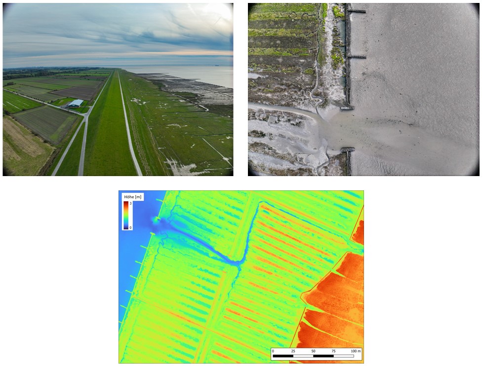
Monitoring and situational awareness for more resilient coastal regions

Resikoast

Climate change poses new challenges for Germany's coastal regions and inland areas. In addition to a predicted rise in sea levels, climate researchers expect an increasing number of extreme weather events such as storm surges, storms and heavy rainfall. The intensity, frequency and possible simultaneous occurrence expose islands and coastal regions to increased risks, which can manifest themselves in particular in the direct endangerment of the population and the failure of critical infrastructure, such as seaports, to supply the population. In addition, the great importance of sea-bound flows of goods increases the risk of cascading direct effects on coastal infrastructures such as harbours to transport routes in the hinterland and, accordingly, to supra-regional supply chains.

In order to adequately counter these risks, it is essential to strengthen the resilience of coastal regions. On the one hand, this requires strategies that ensure long-term adaptation to changing climatic conditions. On the other hand, tools and plans must be developed for the event of disasters that enable early detection and efficient mitigation of the risks that occur. The project has four overarching objectives, which are intended to make a substantial contribution to increasing resilience to the consequences caused by climate change:

  1. development of methods and tools for comprehensive and anticipatory monitoring of coastal extreme weather events.
  2. research and development of AI methods for analysing remote sensing data with the aim of monitoring dynamic phenomena, detecting anomalies in time series and predicting future climate-relevant trends in the region.
  3. development of methods for the holistic assessment of the impact of extreme weather events and measures on logistics chains, harbours and coastal supply infrastructure.
  4. development of tools and measures to mitigate short-term hazards associated with climate change and the identification and evaluation of opportunities for long-term adaptation of coastal infrastructures for protection and security of supply.

The DLR Institute of Data Science contributes to the project in three different ways

  • New monitoring and situational awareness methods are explored by using web data (for example web pages, texts or images) to complement satellite-based products. A key research question is how information from weather databases and news articles can be used to understand past extreme weather events and their impact on the population and infrastructure. These findings support KRITIS operators in deriving trends and taking measures to minimise risk.
  • In cooperation with the German Weather Service (DWD), the network of weather sensors in selected coastal regions is being extended in order to improve the quality of weather models for forecasting. The extent to which the new sensors generate added value, for example in terms of improving local weather forecasts and validating forecast models, is also being investigated.
  • Drone-based cameras are used to record dykes in order to create detailed 3D models of the dyke geometry and analyse the image data, for example with regard to vegetation. Regular measurement campaigns serve as the basis for recognising and quantifying changes to the dykes. This allows potentially dangerous developments, which often occur during storm surges, to be recognised at an early stage before they affect the stability of the dyke or the infrastructure in the dyke foreland.  

This valuable information enables the responsible authorities to initiate the necessary protective measures in a timely and targeted manner based on sound knowledge. As a result, the stability of the dyke infrastructure can be reliably maintained and significant hazards can be preventively minimised.

Project duration: 01/2023 - 12/2025

Participating institutes and facilities