FlexiGIS – Optimisation framework for urban energy systems
Modelling tool
FlexiGIS – Optimisation framework for urban energy systems
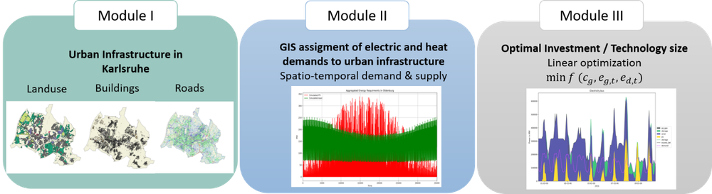
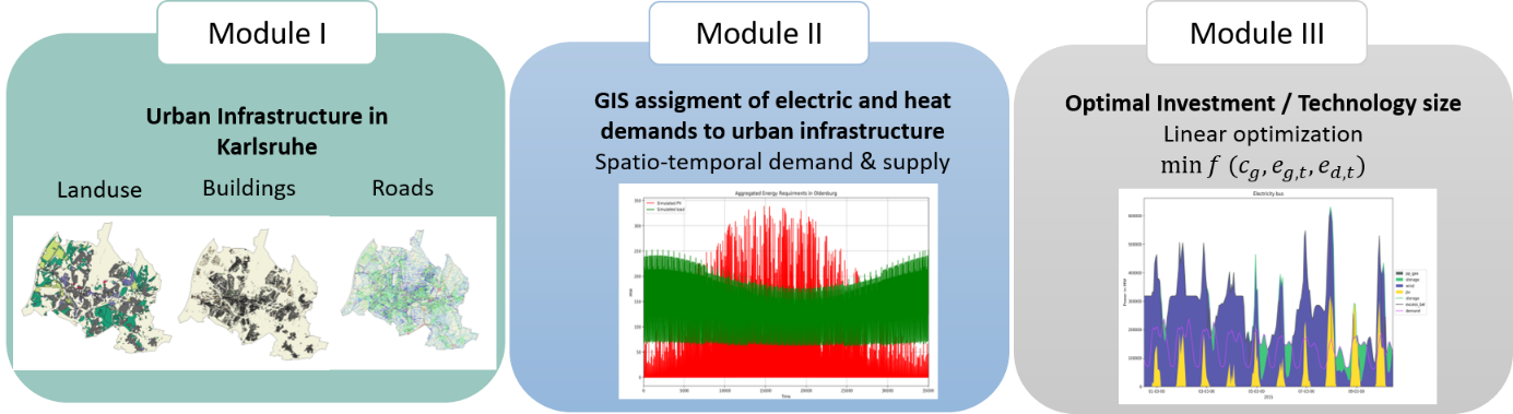
FlexiGIS software modules
FlexiGIS can be used to map urban infrastructures (Module I) and to simulate and geographically allocate urban energy requirements (Module II). The determination of the most economically cost-effective deployment planning of different technologies (Module III) is a further component of FlexiGIS.
The open source optimisation framework FlexiGIS developed at the Institute of Networked Energy Systems can be used to map and model the individual conditions of urban energy systems. FlexiGIS processes data from geographic information systems (GIS) about urban areas and calculates the most economically cost-effective deployment planning for different technologies. Areas of application are the determination of the degree of self-sufficiency or the mapping and evaluation of future developments of urban energy systems.
The open source optimisation framework for urban energy systems FlexiGIS (Flexibilisation in Geographic Information System) uses publicly available data sets to map, classify and model urban energy infrastructures, prioritising georeferenced data. These datasets include, for example, building areas, roadways or information on land use. FlexiGIS supplements these data sets with modelled data, for example on the electricity requirements of individual buildings, by taking into account various characteristics such as building age or population data. Furthermore, an optimisation environment makes it possible to calculate the most economically cost-effective use of different technologies while ensuring security of energy supply. Any limitations of technologies, for example due to a lack of expansion areas, are taken into account as boundary conditions. By mapping and evaluating different development scenarios for the urban energy system, the degree of regional self-sufficiency and flexibility potential can also be quantified.
Due to its transferability, FlexiGIS offers global support in the implementation of strategies for sustainable urban energy systems. Scientific studies have already been carried out for the two German cities of Oldenburg and Berlin as well as for Philadelphia (USA).
More information on the topic:
FlexiGIS open source Note: Project-specific further developments are currently (as of January 2025) being carried out in DLR's internal GitLab and will be updated under this link once completed.
Departments, research groups and challenges related to the FlexiGIS optimisation framework:


