
The acquisition of the laser link is the most critical step in the commissioning phase of an inter-satellite laser interferometer, such as the Laser Ranging Interferometer (LRI) on board the GRACE Follow-On Mission. With the Miniaturized Constellation Acquisition System (MiniCAS), DLR is developing a sensor system that will drastically shorten this process and make it safer.
MiniCAS
The acquisition of the laser link is the most critical step in the commissioning phase of an inter-satellite laser interferometer, such as the Laser Ranging Interferometer (LRI) on board the GRACE Follow-On Mission. This mission involves two satellites in low Earth orbit operating an interferometric laser link over a distance of approximately 220km. This measurement technology can be used to determine changes in the Earth's gravitational field, which can be used, for example, to better understand climate change.
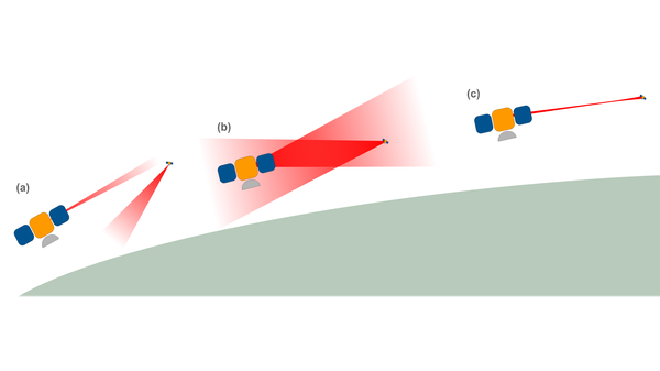
Tolerances in the production and integration of the satellite and interferometer components, vibrations during rocket launch and other effects, e.g. thermal effects, cause the interferometer to tilt in relation to the line of sight between the satellites. Through this, the emitted laser beams would not hit the respective other spacecraft (see (a) in above figure). This tilt is determined and subsequently corrected as part of the link acquisition procedure (see (b) and (c)). The LRI on board GRACE-FO had to carry out several complex spatial scans of the laser beams lasting around 9 hours each.
With the Miniaturized Constellation Acquisition System (MiniCAS), DLR is developing a sensor system that will drastically shorten this process and make it safer. The following figure shows the basic functional principle.


Measurement principle of MiniCAS
Credit:
J. van den Toren / DLR (alle Rechte vorbehalten)
The transmitter unit of the MiniCAS system consists of a light source with a sufficiently large beam divergence to cover the entire uncertainty cone without any spatial scans (see drawing (a) in the figure). Such a signal is often referred to as a beacon beam. On the receiving satellite, the light enters the MiniCAS system through an aperture and is focused on the sensor by a lens system. Over the distance, the beam emitted by the transmitter resembles a spherical wave front. If the transmitting spacecraft tilts, the beam also tilts. However, the section of the beam that enters the aperture shows no change in angle (see (b)). However, when the receiving spacecraft tilts, the beam passes through the aperture at an angle (see (c)). The lens system converts this inclination into a beam offset on the sensor.
Using this measuring principle, tilts of the satellites in relation to their line of sight can be measured with a precision in the micro radian range. This corresponds to the accuracy that would be required to reliably point a laser beam to a bicycle at a distance of 200 km.
The MiniCAS system is being developed as part of the ADMIRE project in collaboration with the Institute for Satellite Geodesy and Inertial Sensing in Hanover, the Institute of Space Research in Berlin and DLR Systemhaus Technik in Goettingen.
Project Partners
- DLR Institute for Satellite Geodesy and Inertial Sensing, Hanover
- DLR Institute for Space Research, Berlin
- DLR Systemhaus Technik, Goettingen
Beteiligte Abteilungen
Loading
Contact
Dr. rer. nat. Alexander Koch
Commissary Head Laser Interferometric Sensing
German Aerospace Center (DLR)
Institute for Satellite Geodesy and Inertial Sensing
Laser Interferometric Sensing
Callinstrasse 30b, 30167 Hannover
Germany