Based on the already completed project ‘5G-Reallabor in der Mobilitätsregion Braunschweig-Wolfsburg’, the ADELE project started in June 2024. The components already developed are to be connected to a Frequentis system, which in turn is connected to the control centres of the Rostock fire brigade and the Mecklenburg-Vorpommern state police. The aim is also to improve the information situation at emergency scenes before the first emergency services arrive and also to provide a constant picture of the situation during the course of the operation. A drone is used for this purpose, which is requested and sent by the Frequentis system in the event of a (simulated) emergency.
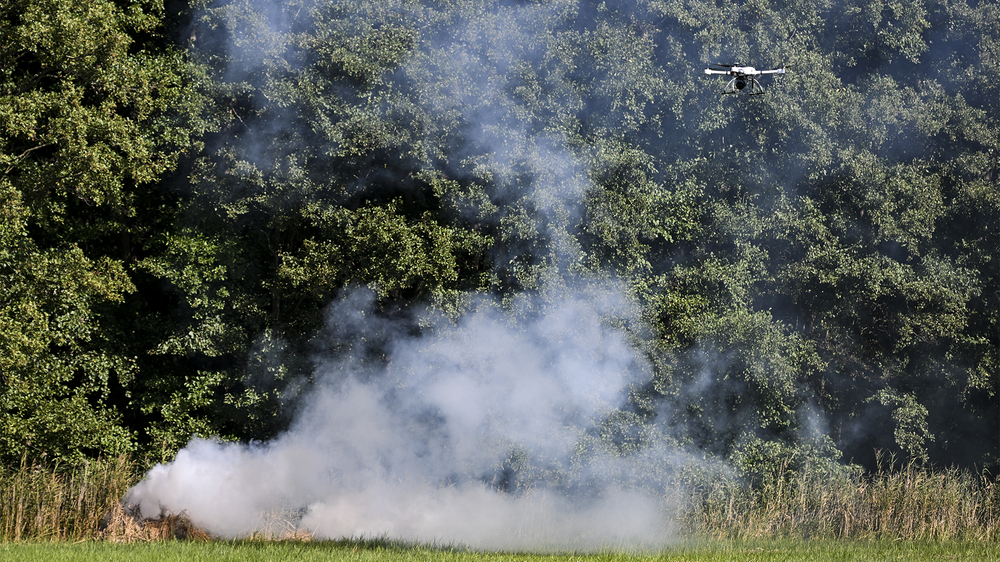
In the future, drones will automatically take off for the scene of an emergency immediately after an emergency call is received and send initial aerial images to the emergency services control center – even before the emergency services arrive. This could significantly speed up response times for rescue operations. It is precisely this support from drones in rescue operations that was tested in the ADELE project by the German Aerospace Center (DLR), Vodafone, Frequentis, and the Rostock Fire Department.
ADELE: Assistance from Above
Your consent to the storage of data ('cookies') is required for the playback of this video on Quickchannel.com. You can view and change your current data storage settings at any time under privacy.
ADELE: Assistance from Above
In the future, drones will automatically take off for the scene of an emergency immediately after an emergency call is received and send initial aerial images to the emergency services control center – even before the emergency services arrive. This could significantly speed up response times for rescue operations. It is precisely this support from drones in rescue operations that was tested in the ADELE project by the German Aerospace Center (DLR), Vodafone, Frequentis, and the Rostock Fire Department.
Credit:
DLR, Vodafone, Frequentis, Feuerwehr Rostock
Although the special drone laws do not apply to BOS operations (authorities and organisations with security tasks), the head of operations wants to be able to assess the risk of a drone operation quickly and precisely, using additional software from a subcontractor that assesses the risk based on the planned route using the SORA (Specific Operation Risk Assessment) method. This assessment takes into account not only the network coverage of the Vodafone mobile network, but also the forecast population density. This is not derived from static census data, as is usually the case, but from anonymous live data from mobile phones within a mobile phone cell. In this way, the current ground risk can be determined, which indicates the current risk of the drone operation to the operations manager at different times of the day.
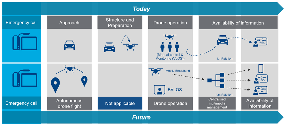
A fire service incident commander can only properly assess the situation once they are at the scene. In order to shorten this time, a rescue drone will automatically fly to the scene of the accident if necessary in order to send live video streams (optical and thermal) directly to the fire brigade's operations control centre. Object recognition enables the automatic detection of vehicles, people and hazardous goods signs and helps to quickly gain an organised overview of the situation. This enables the emergency services to gain a better overview of the situation and request or deploy the necessary resources more quickly.