DLR 5G drone delivers live emergency scene images before rescuers arrive
September 24, 2025 | Automated aerial surveillance support for rescue operations
DLR 5G drone delivers live emergency scene images before rescuers arrive
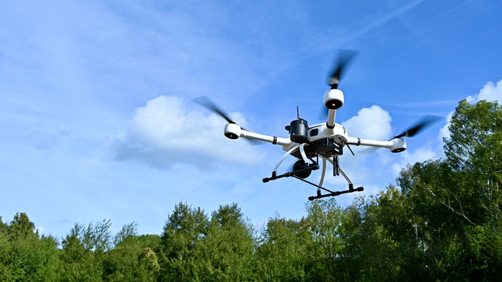
Automated emergency response drone
A drone takes off on an automated flight as part of the ADELE project. It delivers high-resolution live images from the scene of an emergency even before the emergency services arrive.
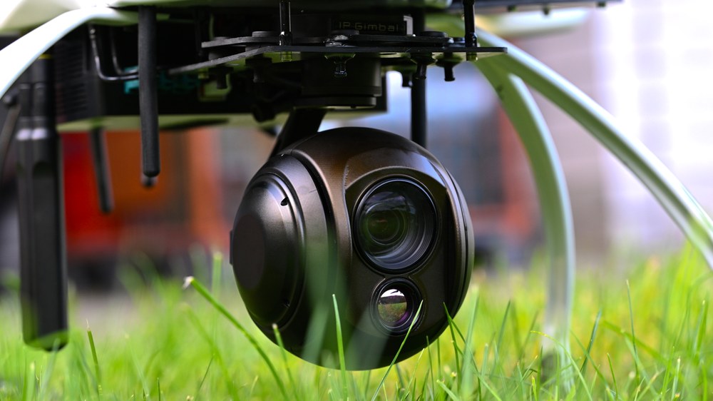
Camera sensors for situational awareness during operations
Close-up of the high-resolution camera on the emergency response drone. The sensor technology provides real-time images from the air and improves the situation assessment for emergency services.
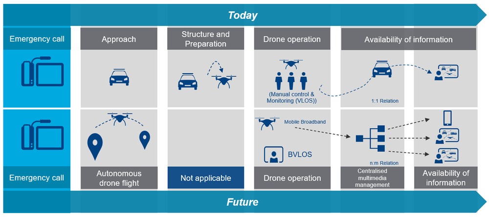
Comparison of procedures following an emergency call: While manual control and longer preparation times are necessary today, the ADELE project will enable future autonomous drone flights with direct integration into control centre systems. This will make information available more quickly and centrally to many emergency services.
Image: 4/4, Credit:
ADELE Konsortium and Frequentis AG
DLR, Vodafone, Frequentis and the Rostock fire brigade are currently testing drone support for rescue operations.
In the future, drones will take off automatically and head to an emergency scene immediately after the emergency call, transmitting initial aerial images to the emergency services control centre – even before the relevant personnel arrive.
This early surveillance will significantly reduce rescue response times.
Focus: Aviation, uncrewed aerial systems (UAS), disaster relief
Every second counts for emergency services and rescue personnel in the event of a forest fire, traffic accident or natural disaster. Yet at the start of an operation, precise information about the situation on the ground is often scarce – especially in complex terrain or areas that are difficult to access. For this reason, Vodafone, Frequentis and the Rostock fire brigade – led by the German Aerospace Center (Deutsches Zentrum für Luft- und Raumfahrt; DLR) – have joined forces in the ADELE project to improve conditions for emergency responders. For the first time, they are now testing the deployment of automated drones immediately following an emergency call. Even before rescuers arrive, the drones can transmit high-resolution live images from the incident site directly to the emergency control centre. Timely images allow emergency responders to gain an early impression of the situation and provide targeted assistance more effectively – saving valuable time when it matters most. On 23 September 2025, a complex exercise scenario took place near Rostock, Germany, to test such drone support.
"With the ADELE project, we are bringing modern drone technology directly into rescue operations," says DLR Executive Board Chair Anke Kaysser-Pyzalla. "This will enable emergency services to reduce their response time to just a few minutes on average. Every second gained is valuable – to save lives in emergency situations, protect infrastructure, safeguard assets and the preserve the environment. We are delighted to contribute DLR's extensive expertise in the field of uncrewed aerial systems to this endeavour. Our solution-driven and goal-oriented research forms the basis for successful cooperation with public stakeholders and other users."
Andreas Volkert, ADELE project manager and uncrewed aerial vehicle expert at the DLR Institute of Flight Guidance, adds: "Alongside coordinating the project, we are also responsible for the system architecture, providing the drone itself and contributing the tools for planning and executing flight routes. Our rescue drone combines high-resolution camera sensors with optimised, low-risk flight control components based on real-time motion data. We ensure compliance with all legal regulations and full GDPR conformity to safeguard safety and data protection."
Chris von Wrycz Rekowski, Senator for Finance, Digitalisation and Order for the Hanseatic and University City of Rostock, says: "With ADELE, we are bringing greater speed and clarity to the daily work of the police, fire brigade and other rescue services. The live images provide emergency responders with valuable information that not only offers a better overview but also saves valuable time. This allows for faster and better decision-making, and an even faster response."
5G drone – aerial support for emergency services
ADELE stands for 'Automated Drone Deployment from the Control Centre' (Automatisierter Drohneneinsatz aus der Leitstelle). As part of the project, Vodafone is providing 5G technology for real-time data transmission along with a new end-to-end encryption technology for maximum security. Frequentis is providing the connection to the control centre, and the Rostock fire brigade is testing the application in real-life operations. The result: automatic planning of drone flights as soon as an emergency call is received. DLR's drone launches automatically towards the incident location and streams high-resolution video footage to the emergency services control centre in real time – before the first emergency vehicle has left the station. Via the 5G network, emergency personnel receive key information at a very early stage, including information about how a fire is developing, access routes, potentially hazardous material storage locations and the distribution of people in the affected area.
Digital support for emergency management, safe drone flights and faster approvals
To ensure the seamless integration of drone flights, communications and control centre coordination, Frequentis and DLR are connecting drone control directly with the ASGARD and LifeX control centre systems – established communication systems used by the fire brigade and police respectively. The Automated Drone Dispatch System (ADD) is connected via a special interface. When an emergency call is received, the control centre software transmits the incident location, determined from emergency call data, to the ADD in the form of geocoordinates. The ADD then evaluates the geodata and suggests a possible drone deployment.
The operational planning team then decides whether a drone mission is appropriate. If it approves the deployment, the system automatically plans the optimal flight route and sends the rescue drone directly to the destination. At times, a drone may need to fly beyond the visual line of sight (BVLOS) of the control centre, and such flights are subject to particularly strict regulations. To streamline the approval process, Vodafone has developed the DroNet Hub – a platform that gathers anonymous live data from mobile phones within a mobile radio cell, providing a realistic assessment of the actual ground risk. Until now, population data required for approvals has been gathered from statistical data, some of which may no longer be current. For the test project, demonstration flights remained within visual line of sight.
The ADELE project (Automated Drone Deployment from the Control Centre) is funded by the German Federal Ministry of the Interior through the Federal Agency for Public Safety Digital Radio (BDBOS). ADELE is testing the use of drones within the real-life operational environment of the Rostock fire brigade. Through ADELE, project collaborators are introducing greater speed and clarity to the daily operations of the police, fire brigade and other emergency services.
Contact
Jasmin Begli
Corporate Communications Braunschweig, Cochstedt, Stade and Trauen
