Situational awareness of infrastructures
In the past, situation pictures of security applications were presented on maps or screens using a two-dimensional portrayal on a map basis, with a numerous graphic elements to depict the terrain, teams and vehicles.
These representations were often very complex and therefore sometimes confusing, required a lot of time to update and were only accessible in their entirety at the crisis control centres. The situation status was therefore neither up to date, nor was it possible to transmit the current situation by means of low-bandwidth communication channels in a timely manner. Task forces frequently had to verbally communicate via radio or text messages just to get an overall situational assessment during the mission.
In developing systems for the position detection of infrastructures, the Institute for the Protection of Maritime Infrastructures concentrates on maritime scenarios and their wider environments, such as port cities and coastal zones, port facilities, transport and transit routes, security and energy facilities and sea routes. The requirements for operation (24/7) under poor weather and visibility conditions in a maritime setting are extremely strict, requiring high spatial resolution and positional accuracy. Near-real-time solutions are indispensable due to the high traffic densities and the multitude of threats to the infrastructure in the form of accidents, disasters, weather events and potential terrorist attacks in particular.
This calls for new solutions in the development of sensors, fast on-board processing, data transfer and automated data analysis (machine learning), together with predictive analysis of potential risks due to technical errors or attacks on the system.
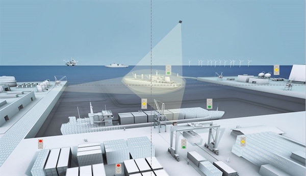
The mission is to combine, in near-real-time, a large selection of available information (AIS, coastal radar, weather data, route plans, positional data) with remote sensing data (optical und radar-based satellite data) and – in crisis situations especially – innovative sensor data (air, ground, ship, sonar and laser measurement data (see Image 1 for synchronously used sensor systems) and to use this information to create a new 2D or 3D situation picture according to the requirements. The near-real-time creation of three-dimensional situation pictures requires the greatest possible synchronisation in the monitoring of maritime structures (vessels, port facilities, cranes) in order to capture the geometrical structures of the objects, use these for identification purposes and measure the movements of the individual objects relative to each other, for example to plan a rescue mission or an attack.
The situation picture thus is more like a ‘3D situation world’ that can be shown in time slices along the entire observation period, including the movement of objects (for example persons, vehicles, containers) or the planned arrival of particular objects within the situation scenario.
The situational assessment of these infrastructures extends from the collection of data using innovative sensor technology, through to the presentation of a protection status-assessed situation picture.
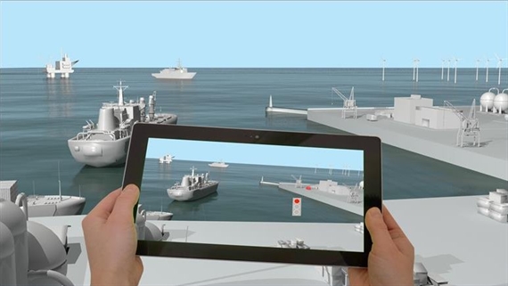
The situation picture must be continuously automated and continuously updatable on request, while the data volume should be kept as low as possible in order to enable the transfer of essential content to other user systems with low bandwidth. This situation picture system should also contain concepts that allow further compression of the information. The situation analysis derives from a dynamic and predictive analysis and presentation of scenario content, through to the classification of the protection status of persons or parts of the infrastructure. Conceivable visualisation systems include computer screens, tablets and mobile telephones, as well VR/AR systems (see Image 2). Computer monitors can also be combined with tablets to provide individual users with different contents or enable accessibility according to their respective security clearance status.
Operation of the stationary and mobile systems (stereo visualisation systems) enables the deployment of innovative, virtual ‘situation worlds’ in mission settings, for simulation and training, as well as for post-deployment analyses and assessments.
In addition to the development of an innovative situation picture, there are also plans for interfaces with the current situation picture systems that will permit partners and user institutions to exploit the information provided in their own systems certified for their purposes in near-real-time (up to partial anonymisation of the data). This includes the planned activities for the qualification of cyber-secure data provision.
The institute’s new sensor technologies (active optical camera sensors and sonar systems) and the subsequent data processing and implementation steps, including data transfer, will be demonstrated in exercises conducted with user facilities under the deployment of a variety of carrier platforms (aircraft, UAV, ships, vehicles, towers, underwater vehicles).
Initial findings with a compact range-gating system for the monitoring of coastal areas were obtained during the testing of the TRAGVIS system at Lake Constance (refer to the Sensors Group information).