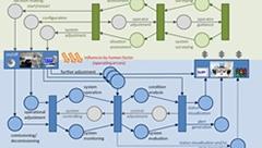

GIS4BOS - Municipal Geographic Information Systems for Public Authorities and Organisations with Security Tasks
Digital means for command and control systems have been gaining in importance. They offer considerable ad-vantages over conventional radio communication and paper-based city and building plans as they enable a coordi-nated, cross-institutional response. The GIS4BOS project aims to create an intelligent, municipally operated platform for different public authorities and law enforcement organisations. The objective is the more efficient handling of large-scale events, specific maritime operations and the continuous evaluation and enhanced tailoring of need and development plans. The city’s existing geographic information system (GIS) will serve as a starting point.