Urban Mobility Accessibility Computer

UrMoAC

Making accessibility visible

The Urban Mobility Accessibility Computer (UrMoAC) is a flexible programme for calculating accessibility measures. UrMoAC takes the existing infrastructure into account and includes helper scripts for importing geodata from the open-world map OpenStreetMap (OSM). It also supports various constraints on searching for destinations, variable aggregation of individual results, and a range of output formats. It can calculate accessibility measures not only for the single modes walking, cycling, motorised private transport (MIV) and public transport, but also for intermodal combinations of transport modes.

How it works

Accessibility measures are calculated via a so‑called breadth‑first search on a graph representing the transport network. The usability of individual routes (permissibility of travel) for the modelled transport modes – walking, cycling, MIV and public transport – is taken into account. Using the scripts integrated in UrMoAC, transport networks as well as various types of origins, such as residential buildings, or destinations, such as schools, can be extracted from OSM data. GTFS files (the file format for timetables) can also be imported to model public transport.

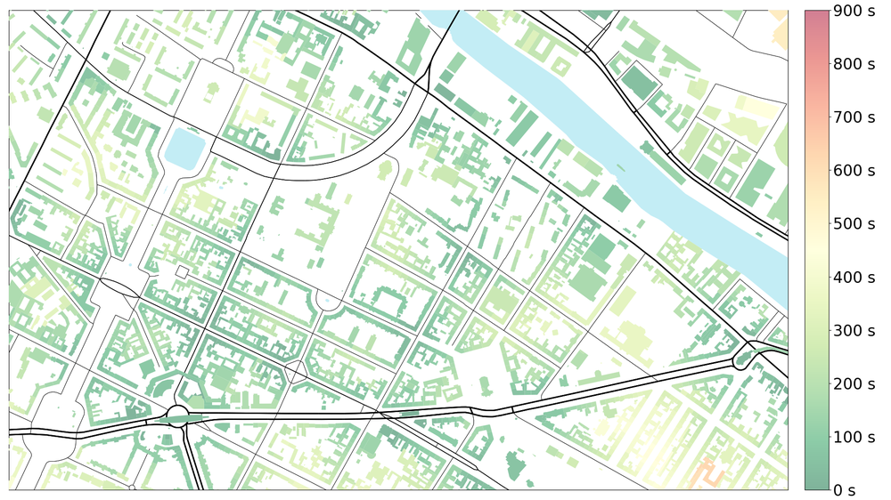
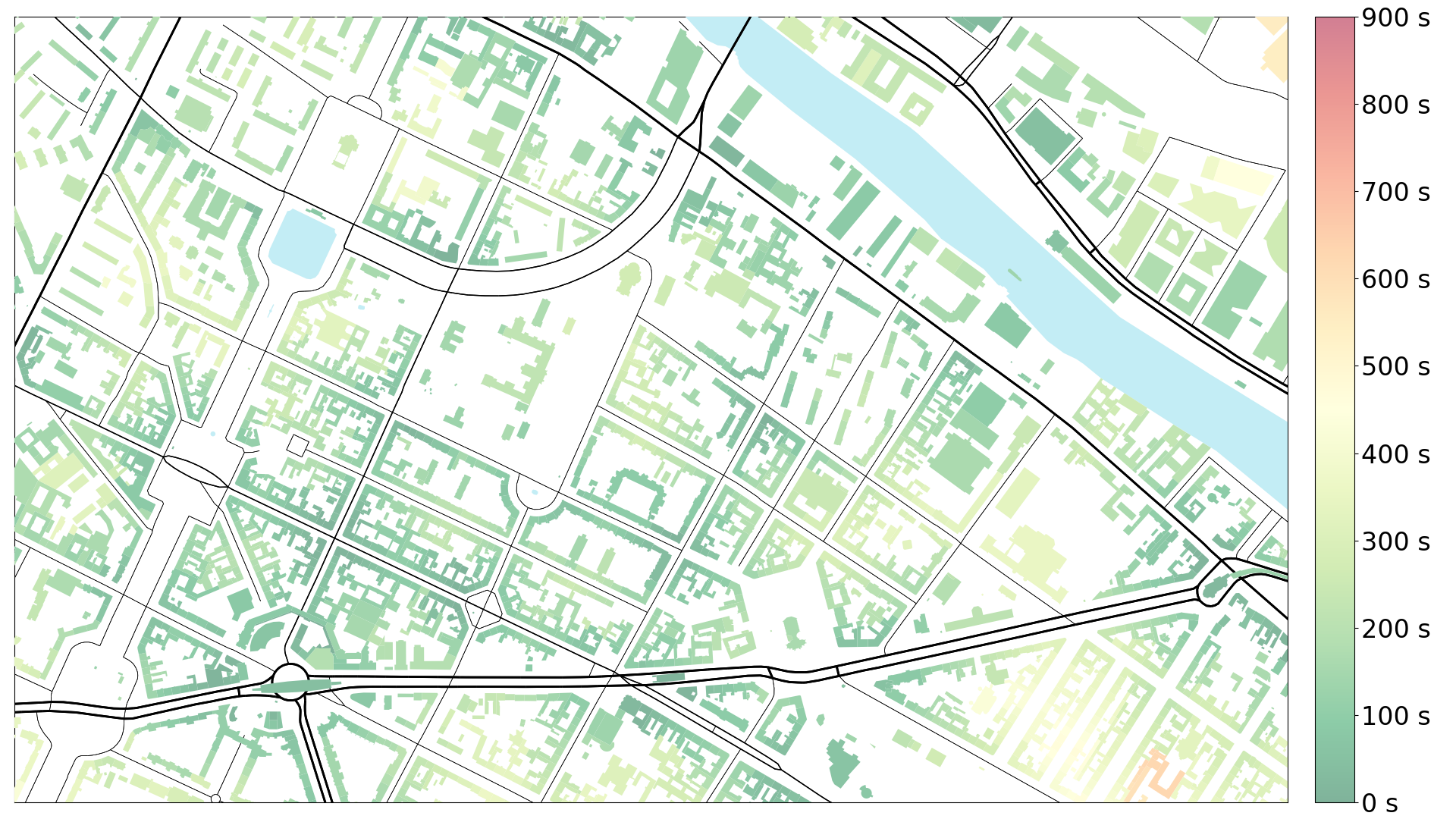
Detailed resolutions of accessibility with buildings
Visualization from UrMoAC enables a detailed resolution of accessibility. For example, access times (in seconds) to the nearest public transport stop in Berlin Kreuzberg can be displayed, allowing better planning for stops or neighbourhoods.

The special feature of UrMoAC is its flexibility. Input data can be read from databases or files, and results can be saved in a variety of formats. The results may be aggregated and weighted according to specific criteria. For example, the accessibility measure can be weighted by the number of people living at the origin, to emphasise the influence of multi‑family dwellings over single‑family houses. Conversely, destinations can also be weighted; an example would be the use of workplaces at the destination locations.

When determining reachable destinations, various constraints can be formulated: only the nearest destination, a given number of destinations, a given travel distance or time, or a target value of the weighting variable. Thus, the average travel time to the three nearest pharmacies can be derived, or alternatively the number of pharmacies reachable within half an hour can be output.

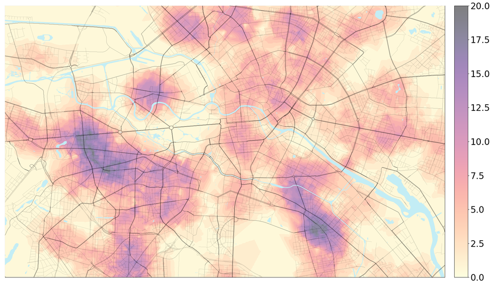
On average, several pharmacies are within walking distance
Even though Berlin has not yet fully achieved the 15 minute target, it is basically possible to reach a pharmacy on foot within 30 minutes. The visualisation from UrMoAC shows that, in some metropolitan areas, the number of reachable pharmacies is even well over ten.
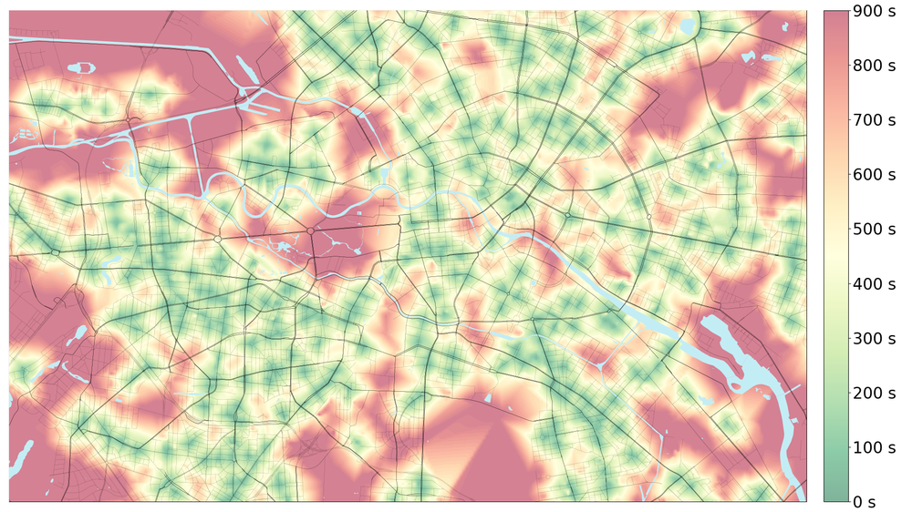
Walking access time to the nearest pharmacy in Berlin
The accessibility measures for Berlin pharmacies calculated with UrMoAC quickly reveal deficits in the visualisation. Following the example of the 15 minute city, pharmacies should be reachable on foot within 15 minutes.

UrMoAC also includes tools for preparing input data and visualising the results. The programme is written in the Java programming language and can therefore be run on virtually any system.

Use, download and installation

UrMoAC is available as open‑source software under the Eclipse Licence 2.0 at https://github.com/DLR-VF/UrMoAC. The DOI is 10.5281/zenodo.13234444.

Related publications

Application of UrMoAC in DLR projects

Contact

Team SKO

Strategy & Coordination
German Aerospace Center (DLR)
Institute of Transport Research
Institutional and Strategic Planning
Rudower Chaussee 7, 12489 Berlin