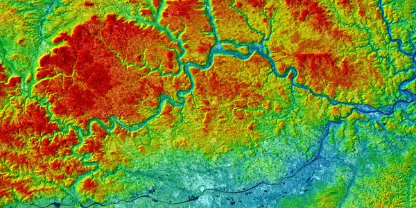
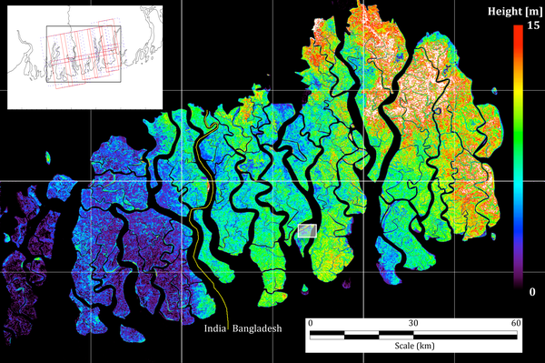
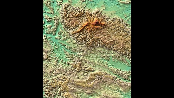
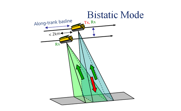
DLR Portal
Home
|
Sitemap
|
Contact
|
Accessibility
Imprint and terms of use
Privacy
Cookies & Tracking
|
Deutsch
You are here:
Home
:
Advanced Search
News
Institute
Departments
Compact Test Range
Projects
TanDEM-X Science
Tandem-L Science
Helmholtz-Allianz
Publications
Awards
Jobs
Offers for Internships, Bachelor, Master and PhD Theses
Archive - Conferences
Software
How to find us
Anreise
TanDEM-X Science Home
TanDEM-X - A New High Resolution Interferometric SAR Mission
TanDEM-X (TerraSAR-X add-on for Digital Elevation Measurement) opens a new era in spaceborne radar remote sensing. The first bistatic SAR mission, is formed by adding a second, almost identical spacecraft, to TerraSAR-X and flying the two satellites in a closely controlled formation with typical distances between 250 and 500 m. Primary mission objective is the generation of a consistent global digital elevation model with an unprecedented accuracy according to the HRTI-3 specifications. Beyond that, TanDEM-X provides a highly reconfigurable platform for the demonstration of new SAR techniques and applications. The mission has been approved for full implementation by the German Space Agency and TanDEM-X is launched on June 21, 2010.
Full article
TanDEM-X News
EUSAR 2024: The extended abstract deadline is approaching
EUSAR, the European Conference on Synthetic Aperture Radar, is the world’s leading international conference dedicated to SAR techniques, technology, and applications. It takes place every two years and is organized by VDE in collaboration Airbus, Fraunhofer, Hensoldt and the German Aerospace Center (DLR). In 2024, VDE and DLR’s Microwaves and Radar Institute are co-organizers. We would like to remind you that the extended abstract deadline for EUSAR 2024 is approaching:
September 30, 2023
. We look forward to your extended abstract submission!
Read more
TerraSAR-X/TanDEM-X Science Team Meeting: Registration Deadline
On behalf of the Organizing Committee, we are pleased to invite you to the TerraSAR-X / TanDEM-X Science Team Meeting 2023 that will be held from Wednesday October 18th to Friday October 20th, 2023 at the German Aerospace Center (DLR), Oberpfaffenhofen, Germany. Please let us remind you that attendees are required to register until
September 22, 2023
.
Read more
CEOS SAR Cal/Val 2023: Workshop Registration
The Committee on Earth Observation Satellites (CEOS) Working Group on Calibration and Validation (WGCV), SAR Subgroup, is organizing the Synthetic Aperture Radar Workshop 2023 (CEOS SAR WGCV 2023). It will be held from Monday, October 16th to Wednesday, October 18th 2023 at the German Aerospace Center (DLR), Oberpfaffenhofen, Germany. Please let us remind you that attendees need to register until
September 15, 2023
.
Read more
Radar imaging from space – the stadiums of the Women's World Cup down under
20 July 2023
The Women's World Cup will take place in Australia and New Zealand from 20 July 2023. The radar satellite duo TerraSAR-X and TanDEM-X imaged the tournament venues from space between May and July this year. By combining several images, vegetation such as parks or meadows appear in green and can be distinguished from urban buildings in blue/white. An elevation model of each venue was also generated.
Read more
IEEE Spectrum: Radar Imaging Could Be the Key to Monitoring Climate Change - The pioneering system can track rising sea levels and deforestation
30 June 2023
For his “leadership and innovative concepts in the design, deployment, and utilization of airborne and space-based radar systems,” Moreira is this year’s recipient of the IEEE Dennis J. Picard Medal for Radar Technologies and Applications. Moreira says he’s honored to receive the “most prestigious award in the radar technologies and applications field.” “It recognizes the 20 years of hard work my team and I put into our research,” he says. “What makes the honor more special is that the award is from IEEE.”
Read more
Press release: Radio telescopes seen from space
19 June 2023
The June highlight images from the twin TerraSAR-X and TanDEM-X satellites show a selection of well-known radio telescope facilities. Radio telescopes look deep into space to explore the secrets of the Universe. Using the radio waves received by these telescopes, astronomers can study interstellar gases, the remnants of supernovae, the Sun and much more. They are also used in the search for potential radio signals from intelligent extraterrestrial beings. Radio astronomy was founded by the US physicist Karl Guthe Jansky, who detected microwave radiation from the Milky Way for the first time in 1933. The first radio telescopes were built in the years following this discovery. Today, more than 100 radio telescopes around the world are being used to explore the vastness of the cosmos.
Read more
Press Release: Is the rise in sea level underestimated?
10 May 2023
New research shows that the baseline of Greenland's Petermann Glacier shifts during tidal cycles, causing warm seawater to accelerate ice melt. This previously unknown interaction could lead to a 200% increase in sea level rise projections for glaciers that close off the ocean when included in models. Our colleagues
Pietro Milillo, Jose-Luis Bueso-Bello
and
Paola Rizzoli
were involved in this study. It was published in Proceedings of the National Academy of Sciences on May 08, 2023.
More
:
Research Article
Spiegel
Finon Wissenschaft
Hardware Infos
Read more
100 Years of Tutankhamun: Discovering the valley of the kings with radar
16 February 2023
100 years ago, British archaeologist Howard Carter opened Tutankhamun's burial chamber. For years he had been searching for the pharaoh's tomb in the Valley of the Kings, northwest of the Upper Egyptian city of Luxor. Almost giving up, he found Tutankhamun's tomb in the winter of 1922. However, several months of careful preparations were needed before the archaeologist could penetrate the interior of the burial chamber. On February 16, 1923, Howard Carter and his team finally broke through the door between the antechamber and the burial chamber. Inside, they found a treasure trove of almost completely preserved burial objects and the sarcophagus of the pharaoh - still a sensational find today
(IN GERMAN)
.
Read more
Solar tower power plants - sunlight becomes electricity on demand
18 January 2023
Solar energy is becoming an increasingly important source of energy worldwide. In Germany, photovoltaic systems are currently predominantly in use. For sunny countries, solar tower power plants with integrated heat storage systems are also a valuable addition. They store heat and can thus generate electricity at any time - even when the sun is not shining. The new highlight images from the TerraSAR-X and TanDEM-X radar satellites present unique images of the Earth in transition and also show solar thermal power plants around the world.
Read more
Season´s Greetings and wishes from TanDEM-X!
23 December 2022
Our Christmas picture this year features Sharm El Sheikh, an iconic Egyptian resort on the Sinai Peninsula. This year, Sharm ash-Shaykh hosted the UN Climate Change Conference (COP 27), held in November 6-12, 2022. Although the final agreement did not include a decisive shift away from fossil fuels, a historic decision was made to establish and operationalize a loss and damage fund, particularly for countries most vulnerable to the climate crisis. Despite all challanges we faced around the wolrd this year, we wish you have a satisfied reflection on the past, faith in tomorrow and hope for the future. Continue to be on the lookout for news from TanDEM-X on
www.dlr.de/HR
.
The DLR Microwaves and Radar Instittute wishes you Merry Christmas 2022 and above all a healthy, successful year 2023!
Read more
DLR Magazin: Looking deep into the forest - A combination of remote sensing data provides new insights into the structure of forests
28 November 2022
Forests are gigantic carbon stores: Half of the carbon bound on earth is stored in them. They also control the transport of water and carbon dioxide between the soil and the atmosphere. Accordingly their role in mitigating climate change. However, changes in temperature and precipitation and worsening weather extremes pose a major threat to forests and their function. Therefore, it is important to know the condition of the Earth's forests and how their structure is changing. To investigate this, DLR scientists combined data from remote sensing missions. But that's not all: a future satellite mission could depict forest structure and how it changes over time in unprecedented quality.
More
:
DLR Magazin
Read more
Icelandic volcano Fagradalsfjall awakened again
09 September 2022
Iceland's Fagradalsfjall volcano has been active again since August 3, 2022. It last awoke on the island in March 2021 after a 6,000-year hiatus. Now, almost a year and a half later, it is once again spewing lava and toxic gases. The volcano is located in the Meradali Valley, about 40 kilometers from the capital Reykjavik. Images taken by the TerraSAR-X radar satellite on August 5 and 27, 2022, show how the current eruption is changing the shape of the volcano and its surroundings.
Read more
Press Release: 15 years in space and as fit as at launch - the German radar satellite TerraSAR-X
14 June 2022
15 years - who would have thought it! The German radar satellite TerraSAR-X was designed for a lifetime of five and a half years, until the end of 2012, when it was launched from the Baikonur Cosmodrome in Kazakhstan at 8:14 a.m. local time on June 15, 2007. Since then, it has provided data of outstanding quality, regardless of weather conditions, cloud cover or daylight. The TerraSAR-X scientific mission and the satellite are operated by the German Aerospace Center (DLR).
Mehr
:
Süddeutsche Zeitung
Read more
Satellites for Earth remote sensing – helpers in times of climate change
07 March 2022
IN GERMAN: Der neue Bericht des Weltklimarates (Intergovernmental Panel on Climate Change, IPCC) macht es deutlicher denn je: Die Weltgemeinschaft muss jetzt handeln! Wenn nicht geeignete Maßnahmen für den Klimaschutz und die Anpassung an den Klimawandel ergriffen werden, dann schließe sich das Fenster der Gelegenheit, eine lebenswerte und nachhaltige Zukunft für alle zu sichern. Bereits jetzt seien mehr als 3,3 Milliarden Menschen in hohem Maße von den Auswirkungen des Klimawandels wie Dürren, Hitzewellen oder Überschwemmungen betroffen, heißt es in dem Bericht. Um die biologische Vielfalt zu erhalten, müssten zwischen 30 bis 50 Prozent der Ökosysteme – Land-, Süßwasser- und Meeresflächen – geschützt werden. Nur so könnten sich diese an die veränderten Bedingungen anpassen.
Read more
Ice-ocean interactions are accelerating melting in West Antarctica
11 March 2022
An analysis of Antarctica’s Pope, Smith and Kohler glaciers by researchers at the University of California, Irvine, NASA’s Jet Propulsion Laboratory, the University of Houston and other institutions has revealed an aggressive pattern of retreat connected to high melt rates of floating ice in the Amundsen Sea Embayment sector of West Antarctica.
In a paper published recently in Nature Geoscience, the team reports that the grounding line — where ice moves off the land and begins to float — of Pope Glacier retreated 3.5 kilometers in 3.6 months for an average of nearly 12 kilometers per year in 2017. Between 2016 and 2018, the western portion of Smith Glacier retreated at 2 kilometers per year and Kohler Glacier at 1.3 kilometers per year.
More:
Nature Geoscience
UCI News
Read more
Shipwreck of the 'Endurance' found – safe navigation thanks to satellite data
11 March 2022
Over a century ago, Ernest Shackleton's ship Endurance sank in Antarctica, trapped and crushed by the ice. The crew survived and the incredible rescue operation made the polar explorer's expedition legendary. The wreck has now been located with the support of the German Aerospace Center (Deutsches Zentrum für Luft- und Raumfahrt; DLR). DLR provided TerraSAR-X satellite images that enabled safe navigation through the ice-covered Weddell Sea. DLR researchers on board the expedition’s ship also studied the properties of sea ice to improve navigation in polar regions.
Read more
DLR Magazin: On the traces of time
31 January 2022
IN GERMAN: Mit dem Start des Radarsatelliten TanDEM-X begann im Jahr 2010 eine neue Ära in der Radarfernerkundung. Seitdem umkreist er im engen Formationsflug mit seinem drei Jahre älteren „Zwilling“ TerraSAR-X die Erde. Zusammen liefern die beiden Satelliten Daten für Höhenmodelle der ganzen Welt. Diese stellen eine unentbehrliche Grundlage für kommerzielle Anwendungen und wissenschaftliche Fragestellungen dar, denn bis dahin existierten für weite Teile der Erde nur grobe, uneinheitliche oder lückenhafte Höhenmodelle unterschiedlicher Datenquellen und Erhebungsmethoden. Die Mission TanDEM-X änderte dies mit ihrem Digital Elevation Model (DEM), einem digitalen Höhenmodell der gesamten Landoberfläche der Erde in einheitlicher Qualität und bislang unerreichter Genauigkeit. Das ist den DLR-Wissenschaftlerinnen und -Wissenschaftlern aber noch nicht genug.
Read more
Glaciers are melting much faster than expected
28 January 2022
IN GERMAN: Der Südpol hat neue Sorgenkinder. Eine Gruppe von kleineren Gletschern schmilzt schneller als erwartet: Pope, Smith und Kohler. Bisher standen die benachbarten Eisgiganten Thwaites und Pine Island im Fokus der Forschung, da sie sehr fragil sind und den globalen Meeresspiegel um bis zu 1,2 Meter ansteigen lassen könnten. Das Deutsche Zentrum für Luft- und Raumfahrt (DLR) hat die Veränderungen in der Westantarktis gemeinsam mit internationalen Forschungspartnern aufgedeckt und analysiert. Den Ursachen für die rapiden Abschmelzungen der kleineren Gletscher kamen sie mithilfe spezieller Radardaten der Satellitenmissionen
TanDEM-X
und COSMO-SkyMed auf die Spur.
Die gewonnenen Erkenntnisse sind wichtig, um Gletscherprozesse besser zu verstehen und so die Entwicklung der gesamten Antarktis vorherzusagen. Klimaforschende können dann künftig noch genauer berechnen, wie stark der Meeresspiegel ansteigen wird und welche Schutzmaßnahmen am wirkungsvollsten sind. Die neue Studie ist aktuell im Fachjournal
Nature Geoscience
veröffentlicht. Sie ist das Ergebnis einer Zusammenarbeit von der University of Houston, dem DLR-Institut für Hochfrequenztechnik und Radarsysteme, der University of California, der Université Grenoble Alpes sowie der italienischen Raumfahrtagentur ASI.
More:
sueddeutsche.de
astronews.com
merkur.de
gispoint.de
heise-online
Raumfahrer.net
Read more
Season´s Greetings and wishes from TanDEM-X!
21 December 2021
Our Christmas picture this year features Rovaniemi, the capital of Lapland, a landscape in Northern Finland. Rovaniemi is the official
hometown of Santa Claus
and the city's most famous resident can be visited every year in Santa's village right in the Arctic Circle. The DEM shows the Finnish hillscape Vaara-Suomi around Rovaniemi in the center of the image. The 204 m high mountain Ounasvaara just East of the city center across the Kemijoki river is a local recreation area for its inhabitants and hosts a skiing center with even seven slopes. Look out for further news on TanDEM-X on
www.dlr.de/HR
.
The Microwaves and Radar Institute wishes you Merry Christmas 2021 and a Happy New Year 2022!
Read more
Satellites as helpers in the fight against climate change
03 November 2021
IN GERMAN: Vom 31. Oktober bis zum 12. November 2021 findet im schottischen Glasgow die 26. UN-Klimakonferenz (COP, Conference of the Parties) unter dem Vorsitz Großbritanniens statt. Vertreter von 197 Vertragsstaaten beraten dort über geeignete Maßnahmen, um die Ziele der UN-Klimarahmenkonvention (UNFCCC) zu erreichen und das Pariser Klimaabkommen umzusetzen. "Die Raumfahrt spielt für die Umsetzung dieser Ziele eine wichtige Rolle, weil sie mithilfe von Erdbeobachtungssatelliten kontinuierlich und über einen langen Zeitraum den Zustand und die Veränderungen unseres Heimatplaneten und damit auch die Ursachen und Folgen des Klimawandels auf einzigartige Weise dokumentiert", erklärt Dr. Walther Pelzer, Mitglied des DLR-Vorstands und Leiter der Deutschen Raumfahrtagentur im DLR. "Im Verbund mit unseren europäischen und internationalen Partnern wollen wir durch unsere Aktivitäten dazu beitragen, dass auf politischer und gesellschaftlicher Ebene dem Klimawandel effektiver entgegengewirkt werden kann."
Read more
Using principles from painting – creating 3D-effect satellite images in true colour
29 March 2021
How can an impression of three-dimensionality be created using a two-dimensional medium? In art, this question arose centuries ago. Certain painting techniques have since evolved to simulate effects of light and shadow, creating a 3D effect for the viewer. Such effects are referred to as trompe-l'œil – they 'deceive the eye'.
Read more
Global Change: The Earth System
18. January 2021
‘Global change’ is not a recently invented term – it has been used since the 1980s to describe changes in the Earth system driven or triggered by human activities. In contrast to climate change, which only deals with one specific issue, global change takes into account a larger range of processes. For many years, DLR has been researching global change with a wide variety of missions. It develops archiving and processing technologies, devises algorithms for extracting relevant parameters from EO data and analyses the results.
Read more
Season´s Greetings and wishes from TanDEM-X!
22. Dezember 2020
Our Christmas star (
Download [11 MB]
) this year comes from Italy and was observed by the TanDEM-X satellite mission. The municipality of Palmanova, a UNESCO World Heritage Site, is located in the Veneto region. It was laid out at the end of the 16th century as a fortified city of the Republic of Venice, and its star-shaped layout followed the concept of Renaissance city planners for an ideal city. In this TanDEM-X image, the surface elevation is shown in colors (dark blue is 12 m and red is 38 m above mean sea level), while the brightness is proportional to the radar backscatter intensity. TanDEM-X was launched in 2010 and has been operating since then together with its twin TerraSAR-X as a bistatic SAR interferometer. This year we are commenmorating 10 years of TanDEM-X operations in close formation flight. The global digital elevation model (DEM) of TanDEM-X has been available since 2016 for commercial and scientific applications. A new edition of this global dataset, denoted as Change DEM, will be available soon. Look out for further news on TanDEM-X on
www.dlr.de/HR
.
The Microwaves and Radar Institute wishes you Merry Christmas 2020 and a Happy New Year 2021!
Read more
On to new heights - 10 years of TanDEM-X
20 December 2020
IN GERMAN: Seit Dezember 2010 bilden die Zwillingssatelliten TerraSAR-X und TanDEM-X, die im engen Formationsflug um die Erde kreisen, ein einzigartiges Radarinterferometer. Was bis 2010 nur in 2D erfassbar war (Bildteil in Schwarz-Weiß), gewann mit dem Satelliten TanDEM-X eine Dimension dazu. Zu sehen ist das Lenadelta in Russland. Der Fluss mündet hier nach 4.294 Kilometern in die Laptewsee, ein Randmeer des Arktischen Ozeans. Die etwa 1.500 kleinen Inseln im Delta ändern permanent ihre Form, weil das mitgeführte Material sich als Sediment ablagert und das Wasser umlenkt. In einem Atlas wäre das gesamte Gebiet nur in einer Höhe dargestellt. TanDEM-X sieht die Unterschiede viel differenzierter – mit einer Genauigkeit, die zwei Meter Auflösung noch übertrifft. Bereits 2016 erstellten DLR-Wissenschaftlerinnen und -Wissenschaftler ein exaktes 3D-Höhenmodell der gesamten Erdoberfläche aus den Daten der Mission TanDEM-X. Seitdem sammeln die Zwillingssatelliten Daten für ein zweites globales Höhenmodell. Das soge-nannte Change DEM (Digital Elevation Model) dokumentiert Veränderungen der Erdoberfläche in drei Dimensionen. Erste Auswertungen zeigen dramatische Entwicklungen wie das Abschmelzen von Gletschern und Eisschilden oder die ungehemmte Abholzung tropischer Wälder.
Read more
Glacial retreat in the Alps – first comprehensive documentation
08 July 2020
A research team from Friedrich-Alexander-Universität Erlangen-Nürnberg (FAU) conducted the first study of area and elevation changes for all Alpine glaciers over a period of 14 years. This involved comparing three-dimensional terrain models obtained from the German radar satellite mission TanDEM-X and the German-US Shuttle Radar Topography Mission (SRTM) between 2000 and 2014. The team combined the elevation models with optical images from NASA’s Landsat satellites. They found that the Alps have lost approximately 17 percent of their total ice volume since the turn of the millennium. The team recently published the results of their study in the journal Nature Communications.
Read more
Congratulations, TanDEM-X – 10 years of 3D mapping from space
25 June 2020
A new era in radar remote sensing began 10 years ago, on 21 June 2010, when the radar satellite TanDEM-X was launched. Since then, it has been orbiting Earth in close formation flight with TerraSAR-X, its three-year-older 'twin'. The distance between the satellites varies between several kilometres and sometimes only 120 metres. This enables the radar sensors to obtain a 3D view of Earth. This is referred to as a bistatic interferometer in space, which allows the terrain structure to be recorded in three dimensions in just one pass. This space mission continues to be globally unique.
Read more
50 Years "Earth Day" - Satellites observe dramatic changes on Earth
21 April 2020
IN GERMAN: Millionen Menschen gingen am 22. April 1970 - heute vor 50 Jahren - in den USA auf die Straßen, um gegen Ölpest, Umweltverschmutzung, Walfang und Giftmüll zu demonstrieren - und sie begründeten damit eine Initiative, die schon bald den gesamten Globus erfassen sollte: Die Umweltbewegung, an die der heutige "Earth-Day" erinnert, hat unsere Zivilisation geprägt - vielfach mit wesentlichen Erkenntnissen aus dem Weltraum. In Corona-Zeiten lautet auch hier die Devise #EarthDayAtHome - unter diesem Hashtag sind beispielhaft Aktionen und Informationen zusammengestellt, die wir von zu Hause aus tun können, um unser Bewusstsein für die Verletzlichkeit und Einzigartigkeit unseres blauen Planeten zu schärfen. Deutschland ist seit dem Start des ersten deutschen Forschungssatelliten AZUR im November 1969 zu einem der weltweit wichtigsten Partner für die friedliche Erforschung der Erde aus dem All geworden. Das Deutsche Zentrum für Luft- und Raumfahrt (DLR) spielte und spielt hier eine Schlüsselrolle mit eigenen Missionen wie dem deutschen Radarsatelliten-Zwillingspaar TerraSAR-X und TanDEM-X und ab 2021 der EnMAP-Mission sowie den deutschen Beiträgen an ESA-Erdbeobachtungssatelliten wie dem ersten europäischen Wettersatelliten Meteosat in den 1970-er Jahren, gefolgt von ERS und Envisat bis hin zum aktuellen europäischen Satellitennetzwerk des Copernicus-Programmes.
Read more
Earth observation using radar interferometry: Development of the Patagonian Ice Fields reveals the enormous complexity of physical interactions
10 December 2019
The glaciers and ice fields in the South American region of Patagonia have been in retreat since the Little Ice Age between the early 14th century and the mid-19th century. In recent decades, the loss of ice masses associated with tropospheric warming has accelerated. From 2000 to 2016 the Patagonian Ice Fields contributed approximately six percent to the eustatic sea level rise of 0.74 millimetres per year.
Read more
U.N. Climate Change Conference – DLR presents Tandem-L Satellite Mission
03 Dezember 2019
IN GERMAN: Die diesjährige Weltklimakonferenz (COP25) der Vereinten Nationen findet vom 2. bis 13. Dezember 2019 in Madrid statt. Im Rahmen des „Earth Information Day 2019“ stellte das Deutsche Zentrum für Luft- und Raumfahrt (DLR) am zweiten Tag des Klimagipfels Tandem-L vor, den Vorschlag für eine neuartige Satellitenmission zum Monitoring der Erde. Mithilfe von Tandem-L könnten zukünftig die Auswirkungen des Klimawandels überwacht werden und gleichzeitig die Wirksamkeit politischer Maßnahmen zur Eindämmung des Klimawandels kontrolliert werden. Insgesamt zwei Radarsatelliten sollen die Veränderungen der Erde im Wochenrhythmus erfassen – in hoher Auflösung und unabhängig von Wetter oder Tageszeit.
Read more
10 Years Microwave Research in "TechLab"
IN GERMAN: Die Forschungsarbeit des Instituts für Hochfrequenztechnik und Radarsysteme im Deutschen Zentrum für Luft- und Raumfahrt (DLR) blickt auf jahrzehntelange Erfahrungen zurück. Am Standort Oberpfaffenhofen wurden bereits in den 1930er Jahren die Eigenschaften von Antennen und deren Funktionsweise untersucht. Seit dieser Zeit werden Messverfahren und Techniken stetig weiterentwickelt. Im Jahr 2009 wurde mit dem Bau des "TechLab" ein hochmodernes Forschungsumfeld erschaffen, das bis heute auch zukünftigen Ansprüchen der Forschung gerecht wird. Das Institut erweiterte damit seine einzigartige Infrastruktur für die Entwicklung innovativer Erdbeobachtungsmissionen wie aktuell der Vorschlag für die Radarsatellitenmission Tandem-L.
Read more
German radar satellites provide precious environmental data
24 October 2019
IN GERMAN: Es ist heute kein Geheimnis mehr, dass sich unsere Umwelt seit Beginn der Industrialisierung rasanter verändert als zuvor. Die deutschen Satellitenmissionen TerraSAR-X und TanDEM-X liefern seit 2007 und 2010 einzigartige Erdbeobachtungsdaten, aus denen reichhaltige Erkenntnisse über unsere Umwelt gewonnen werden können. Wissenschaftliche Nutzer aus der ganzen Welt sind am Deutschen Zentrum für Luft- und Raumfahrt (DLR) in Oberpfaffenhofen zusammengekommen, um im Rahmen des „TerraSAR-X und TanDEM-X Science Meetings“ die aus den Daten gewonnenen Ergebnisse auszutauschen und Anforderungen an künftige Fernerkundungstechnologien zu formulieren. In mehr als 100 Präsentationen offenbart sich vom 21. bis 24. Oktober 2019 der neueste Stand der Forschung. Begleitend dazu stellt der TanDEM-X-Blog Vorträge aus dem „Science Meeting“ vor und skizziert, in welcher Weise die Daten der zwei Radarmissionen Forscher weltweit unterstützen.
Read more
TanDEM-X Science Team Meeting (October 21 - 24, 2019): Preliminary Program now available
25 September 2019
The TerraSAR-X / TanDEM-X Science Meeting approaches. It takes place at DLR Oberpfaffenhofen. Please register until
Oktober 11, 2019
. A preliminary program is now available:
DOWNLOAD
.
Read more
TanDEM-X Earth observation mission: Tidal glaciers in Greenland – TanDEM-X elevation models show strongest decline in 80 years
13 September 2019
The Kangerlussuaq Glacier is the largest glacier on the southeast coast of Greenland and flows into the fjord of the same name. The glacier front, which in the past was protected by an ice mélange – a mixture of sea ice and calved icebergs – is retreating at an increasing rate. The glacier calves approximately 24 cubic kilometres of ice into the ocean every year. This corresponds to about five percent of the amount of ice lost annually by the entire Greenland ice sheet. Using a time series of 150 TanDEM-X elevation models of the Kangerlugssuaq Glacier, scientists from Swansea University in the United Kingdom have measured the decrease in the glacier’s surface height.
Read more
South America: TanDEM-X reveals glaciers in detail
12 June 2019
A precise understanding of glacier evolution requires knowledge of a glacier's exact mass. This is important in South America, in the tropical regions between Bolivia and Venezuela, where meltwater from glaciers provides drinking water during the dry season. However, basic data about mass changes in glaciers are not easy to obtain. Mass losses are also contributing to rising sea levels on a global scale. As a new analysis method using TanDEM-X data shows, this is particularly true for Patagonia.
Read more
TERRA_Byte – Top computing power for researching global change
27 May 2019
One of Europe's largest supercomputing centres – the Leibniz Computer Centre (LRZ) of the Bavarian Academy of Sciences – and Europe's largest space research institution – the German Aerospace Center (Deutsches Zentrum für Luft- und Raumfahrt; DLR) – will work together to evaluate the vast quantities of data acquired by Earth observation satellites alongside other global data sources, such as social networks, on the state of our planet on a daily basis.
Read more
Global TanDEM-X forest map is available
06 May 2019
Forests are Earth's lungs; they help to reduce greenhouse gas concentrations in the atmosphere and thus counteract global warming, while also providing protection and resources for humans, animals and plants – and they are being lost at an alarming rate. As the view from space reveals, forests cover about one third of Earth’s landmass today. More than half of the world’s forests, which have fallen victim to deforestation since the middle of the 20th century in particular, have already been lost. The German Aerospace Center (Deutsches Zentrum für Luft- und Raumfahrt; DLR), Microwaves and Radar Institute (HR) has created a special dataset to monitor, assess, and protect the current state and development of this green organ with precision – the global TanDEM-X Forest/Non-Forest Map.
Read more
Waves on ice - "Radar Eye" TanDEM-X monitors trucks on ice roads
13 March 2019
IN GERMAN: Eine Studie vom Canada Centre for Mapping and Earth Observation untersuchte den Nutzen von TanDEM-X für die Unterstützung des Eisstraßenmanagements mit Fokus auf den nordwestlichen Territorien Kanadas. Dabei entstand aus zwei TanDEM-X-Datensätzen eine Abbildung, auf der wellenförmige Hebungen und Senkungen einer Eisdecke zu erkennen sind. Ursache sind die Ice Road Trucks, die in den Wintermonaten über die gefrorenen Seen in Kanada transportieren.
Read more
Glacier shrinkage in Antarctica: Better Predictions thanks to innovative radar technologies
01 February 2019
IN GERMAN: Der Thwaites Gletscher gehört zu den fragilsten Gletschern der Westantarktis und schmilzt mit zunehmender Geschwindigkeit unaufhaltsam in die Amundsen See. Bislang ist er für rund vier Prozent des globalen Meeresspiegelanstiegs verantwortlich und kann mit seinen verbleibenden Eismassen die Ozeane künftig um mehr als 65 Zentimeter steigen lassen. Mithilfe der deutschen Radarsatelliten TerraSAR-X und TanDEM-X ist es erstmals möglich, den Thwaites Gletscher und andere Polgebiete flächendeckend mit hoher Auflösung dreidimensional zu vermessen und regelmäßig zu beobachten.
Read more
Season´s Greetings and wishes from TanDEM-X!
23 December 2018
All people living in the world today are descended from Africans who left the continent at least 100,000 years ago. Those who stayed behind continued to innovate and develop their knowledge and ideas. The TanDEM-X image above shows the topography of Cape Town and its surroundings.
Table Mountain
, a well-known landmark of the city, is seen just south of the harbor area. The Cape Town region is characterized by an extensive coastline, rugged mountain ranges, coastal plains, inland valleys and semi-desert fringes. TanDEM-X was launched in 2010 and has been operating together with its twin TerraSAR-X as a bistatic SAR interferometer since the beginning of 2011. The global digital elevation model of TanDEM-X became available in 2016 and surpassed all expectations. It has 99.9% coverage, 12-m posting, absolute height accuracy of approximately 1 m. This unique data set has been available since then for commercial and scientific applications. This year, the low-resolution version of the TanDEM-X digital elevation model with 90-m posting has been released for free download for scientific applications. Look out for further news on TanDEM-X at
www.dlr.de/HR
The Microwaves and Radar Institute sends many Season´s Greetings and wishes you a Happy New Year 2019!
Read more
Claudia Roth, Member of the Bundestag, visits HR Institute
20 December 2018
Climate research and remote sensing have been the topics when Claudia Roth, Member of the Bundestag, the German parliament, came to the German Aerospace Center (DLR) on 20 December 2018. One of five stations in DLR was a short visit at our Institute. Amongst other things, she also informed herself about TanDEM-X and the anticipated Tandem-L SAR satellite mission, initiated by the HR Institute. Tandem-L will provide, in weekly rhythm, latest data to dynamically running processes on the Earth surface (ARTICLE IN GERMAN).
Read more
Global 3D elevation model from the TanDEM-X mission now freely available
08 October 2018
The 90-metre TanDEM-X Digital Elevation Model has been released for scientific use and is now available as a global dataset. By providing this data, the German Aerospace Center (Deutsches Zentrum für Luft- und Raumfahrt; DLR) follows the EU data policy under the Copernicus Earth observation programme, which encourages free and open access to satellite data.
Read more
Thawing permafrost with radar eyes
14 September 2018
IN GERMAN: Wissenschaftler des Instituts für Hochfrequenztechnik und Radarsysteme des Deutschen Zentrums für Luft- und Raumfahrt (DLR) entwickeln spezielle Radartechnologien und Analyseverfahren, die eine hochgenaue Beobachtung von Permafrost ermöglichen. Permafrost prägt seit Jahrtausenden den Untergrund der arktischen und subarktischen Breiten und reicht von wenigen Metern bis mehr als einen Kilometer tief ins Erdinnere.
Read more
1.000 Kilometers on the ice shelf - withTerraSAR-X
23. Mai 2018
IN GERMAN: Das größte Sicherheitsrisiko beim Überqueren des Schelfeises ist die Spaltenbildung. So können unter der Schneedecke Gletscherspalten verborgen sein, die bis zum Meeresniveau hinab reichen."Ohne die Daten von TerraSAR-X wäre es so, als ob wir uns blind auf einem Minenfeld bewegen."
Read more
PAZ Earth observation satellite successfully launched
22 February 2018
The Spanish Earth observation satellite PAZ was successfully launched on 22 February 2018 at 15:17 CET from Vandenberg Air Force Base in California, United States, on board a Falcon 9 rocket. Interestingly, PAZ is being positioned on the same orbit as the German TerraSAR-X and TanDEM-X radar satellites. Launch video:
HERE
.
Read more
DLR provides satellite data for Hurricane Harvey
30 August 2017
In anticipation of the catastrophic hurricane Harvey, the International Charter 'Space and Major Disasters' was activated early on the evening of 24 August 2017. This was initiated by the Charter member United States Geological Survey (USGS) on behalf of the Texas Emergency Management Council. The German Aerospace Center (Deutsches Zentrum für Luft- und Raumfahrt; DLR) provided real-time recordings and archive data from the German radar satellite TerraSAR-X, which enabled a detailed analysis and an overview of the flood situation.
Read more
Planet Earth in high-precision and in 3-D: State Secretary Matthias Machnig appreciates TerraSAR-X success
05 August 2017
IN GERMAN: 10 Jahre TerraSAR-X: Staatssekretär Matthias Machnig würdigt wissenschaftlichen und industriepolitischen Erfolg der weltweit einzigartigen Erdbeobachtungsmission. Deutschland ist mit TerraSAR-X und seinem Zwillingssatelliten TanDEM-X international führend in der radargestützten Fernerkundung.
Read more
DLR BLOG: TerraSAR-X monitors the "Larsen C" ice shelf break-apart
25 July 2017
IN GERMAN: Wir haben in den letzten Tagen viel in den Medien über den riesigen Eisberg lesen können, der sich am Larsen-C-Schelfeis an der Antarktischen Halbinsel gelöst hat. Dass Eisbergabbrüche von Eisschelfen natürliche Vorkommnisse sind und diese in der Antarktis immer wieder vorkommen, wurde in den Medienberichten richtig dargestellt. Und doch war dieses Ereignis präsenter als die bisherigen. Woran liegt das? Vermutlich daran, dass wir Wissenschaftler seit Monaten mithilfe von Satellitendaten dieses Gebiet der Antarktis verstärkt beobachten und regelrecht darauf gewartet haben, dass es endlich passiert. Außerdem ist diesmal doch ein verhältnismäßig großes Stück Eis abgebrochen, ungefähr sieben Mal so groß wie die Stadt Berlin.
Read more
Excellence in space – 10 years of TerraSAR-X
14 June 2017
Designed to return unique images of the Earth for five years, the German radar satellite TerraSAR-X has outdone itself. The satellite has been in operation for twice that time – and there is still no end in sight to its service.
Read more
Support from space: Navigation through sea ice via radar satellites
27 April 2017
IN GERMAN: DLR unterstützt die Navigation in den eisbedeckten Gewässern durch Aufnahmen der Radarsatelliten TerraSAR-X und Sentinel-1. Erstmals wurden nun neben Radarbildern auch aus Satellitendaten generierte Eiskarten an Bord geschickt – Karten, die Rückschlüsse auf die Dicke und die Befahrbarkeit des Eises erlauben.
Read more
"Luft- und Raumfahrt": Earth Observaton in 3-D - Tandem-L on track to become climate watcher
16 February 2017
IN GERMAN: Am 21. Juni 2010 startete der deutsche Erdbeobachtungssatellit TanDEM-X an Bord einer russisch-ukrainischen Dnjepr-Trägerrakete zu seiner Mission in den niedrigen Erdorbit ... Im September 2016 konnte die erste topografische Karte der Erde fertiggestellt werden. Sie ist 30-mal genauer als alle bisherigen globalen Datensätze. ... Währenddessen stecken die Wissenschaftler aber schon im nächsten wichtigen Projekt. Bereits seit fünf Jahren arbeiten sie an der
Nachfolgemission Tandem-L
, die ebenfalls aus zwei Satelliten im Formationsflug bestehen soll.
Read more
Deutschlandfunk: Satellites for Forests
13 February 2017
Press Release, Deutschlandfunk (IN GERMAN): "Seit 2010 fliegen die Satelliten TerraSAR-X und TanDEM-X nebeneinander um die Erde. Ihre Bilder zeigen, wie sich Städte entwickeln oder wo Wälder verschwinden. Aber ihre Radarstrahlen dringen kaum durch die Baumkronen der Wälder. Ihre Nachfolger sollen es besser machen und auch Informationen über die Struktur von Wäldern liefern." By Jochen Steiner
[PDF]
Read more
Christmas News on TanDEM-X!
23 December 2016
This year, 2016, the processing and mosaicking of the TanDEM-X DEM was completed and it is now available for the science community and commercial users worldwide! The picture above shows a section of the TanDEM-X DEM from Egypt to Israel. Look out for further news on TanDEM-X at
www.dlr.de/HR
. The Microwaves and Radar Institute sends many Season´s Greetings and wishes you a Happy New Year 2017!
Read more
Future technology for glacier research
15 November 2016
IN GERMAN: Am Institut für Hochfrequenztechnik und Radarsysteme des Deutschen Zentrums für Luft- und Raumfahrt (DLR) haben Forscher eine neue Methode zur 3D Vermessung der Erde entwickelt. In enger Zusammenarbeit mit dem Alfred-Wegener-Institut (AWI) konnte diese Methode nun sehr erfolgreich zur Vermessung von Gletschern und Eisflächen angewendet werden.
Read more
How researchers use the latest Earth observation data - Part 3
20 October 2016
Part three of this blog series looks into our dynamic Earth: How is it changing, at what speed and with what consequences? The satellite missions TerraSAR-X and TanDEM-X offer new perspectives, which inspire scientists to take new approaches.
Read more
How researchers use the latest Earth observation data - Part 2
19 October 2016
In the second part of the series on the TerraSAR-X and TanDEM-X Science Meeting in Oberpfaffenhofen, we present further applications for satellite data. This time, for example, biomass is determined with the help of 'Earth observers from space'. Up until Thursday, 20 October 2016, international scientists will use the congress to show their research results on satellite-based Earth observation and to exchange ideas.
Read more
How researchers use the latest Earth observation data - Part 1
19 October 2016
Researchers from across the globe are in Oberpfaffenhofen for the TerraSAR-X and TanDEM-X Science Meeting. For four days, from 17 to 20 October 2016, they have the opportunity to present their results from the data acquired by the two Earth observation satellite missions and exchange information. Here, approximately 200 presentations give an overview of the latest research in satellite-based Earth observation. The radar data are used in various scientific fields, from climate research to geosciences to forestry, infrastructure planning and remote sensing methodology.
Read more
The future of radar – scientific benefits and potential of TerraSAR-X and TanDEM-X
17 October 2016
The German satellite duo TerraSAR-X and TanDEM-X have consistently delivered one-of-a-kind Earth observation data since 2007 and 2010, hence shaping the international research landscape. Now, scientific users from across the globe have gathered for the TerraSAR-X and TanDEM-X Science Meeting at the German Aerospace Center (Deutsches Zentrum für Luft- und Raumfahrt; DLR) in Oberpfaffenhofen, where they will discuss the results obtained from the data and define requirements for future remote sensing technology.
Read more
New 3D world map – TanDEM-X global elevation model completed
29 September 2016
The new three-dimensional map of Earth
has been completed
. Mountain peaks and valley floors across the globe can now be seen with an accuracy of just one metre. The global elevation model was created as part of the TanDEM-X satellite mission; it offers unprecedented accuracy compared with other global datasets and is based on a uniform database.
Read more
Next TerraSAR-X/TanDEM-X Science Team Meeting: October 17-20, 2016 at DLR in Oberpfaffenhofen, Germany
20 July 2016
The main goal of the meeting is the presentation of results, exchange of experiences and the information about the TerraSAR-X, TanDEM-X and Tandem-L mission status. Interested scientists are kindly invited to present their research results in an oral or poster presentation. Preliminary programs, registration, hotel, and general information on the TerraSAR-X, TanDEM-X and Tandem-L workshop can be found on the
Meeting Web Site
.
Read more
Welt am Sonntag: Ruler of 150 Million Square Kilometers (GERMAN)
12 June 2016
IN GERMAN: Seit sechs Jahren vermessen zwei Satelliten die Oberfläche der Erde neu. Ihre Daten liefern einem Team in Oberbayern das Material für die erste komplette Weltkarte in drei Dimensionen – und auch den Anlass für politischen Streit
(Online Article)
.
Read more
DLR Magazin 148 - Remote Sensing 4.0
14 April 2016
Six years after its launch, the TanDEM-X radar satellite mission will achieve its primary mission objective. A digital elevation model of the Earth with unprecedented accuracy is now more than 90 percent complete and available for use by the international scientific community.
Read more
Monitoring natural disasters with satellite images
08 March 2016
The Earth quake on Haiti 2010, a tsunami in Japan 2011 caused by a submarine earthquake or severe floodings that afflict countries as India or Bangladesh: Scientists of Committee on Earth Observation Satellites (CEOS) meet in at the German Aerospace Center (DLR) in Bonn, Germany, in order to debate the way remote sensing images can coordinate help during natural disasters (ARTIKEL in GERMAN).
Read more
Germany's radar eyes in space
22 February 2016
In a formation flight, the German Aerospace Center's satellite twins are mapping the earth in 3-D. Their images make us wonder today: The run of Budapest's new metro tube, line 4, can be seen from space (
ARTICLE in GERMAN
).
Read more
Safer seafaring with satellites
17 February 2016
Sailing in the regions that polar researcher Arved Fuchs is currently navigating in his ship 'Dagmar Aaen' is a not an easy task. The 'Ocean Change' expedition is travelling around the Antarctic Peninsula, stopping off at a number of research stations to investigate how climate change is impacting the local environment. The expedition receives support from the German Aerospace Center (Deutsches Zentrum für Luft- und Raumfahrt; DLR), and the ship has now reached Deception Island. The DLR Earth Observation Center (EOC) is providing the crew with high-resolution
radar images
acquired by the German TerraSAR-X and TanDEM-X satellites.
Read more
Heartfelt Christmas wishes from TanDEM-X
20 December 2015
It is a very special surprise that has been sent from TanDEM-X at this years' Christmas time: a heart from Mother Earth. A lot of beautiful forms have been created in Mother Earth's history, amongst others this well-formed heart. It is part of our TanDEM-X gallery
http://www.dlr.de/hr/tdmx-gallery
of selected TanDEM-X images. Can you find it? In which country does it reside? It is located at coordinate
N 32.47 E 56.42
on the border between two provinces in Iran, at a western edge of Nayband National Park. This park is the worldwide last viable natural refuge for a rare leopard species that does only exist here in Iran. Look out for further news on TanDEM-X at
www.dlr.de/hr
. The Microwaves and Radar Institute sends many season greetings and wishes you Merry Christmas and a Happy New Year 2016!
Read more
Greenland's glaciers are melting - DLR satellites provide data for new long-term study
12 November 2015
IN GERMAN: Bislang galten die Gletscher im Nordosten Grönlands wegen der starken Kälte als sicher vor der Klimaerwärmung. Ein Forscherteam der amerikanischen University of California, Irvine (UCI) konnte nun jedoch in einer Langzeitstudie am Gletscher Zachariæ Isstrøm zeigen, dass die riesigen Eismassen schneller schmelzen als bisher angenommen.
Read more
The most precise map of the world
05 August 2015
The Planet Earth in 3D, and more precise than ever before! Research scientists create, with the aid of two satellites, a map of the world that has 30 times more precision. Those people who are planning an ‘active’ holiday usually take along a lot of gear – and this certainly includes a detailed hiking or biking map with precise elevation readings.
Read more
Cosmic scarring in radar view
12 June 2015
There are just 188 known meteorite craters worldwide. Some span a mere 10 metres, while others extend across 160 kilometres and are significantly more impressive. They all share a common history – an object from outer space must hit the Earth travelling at least 11 kilometres per second, or 39,000 kilometres per hour, to leave behind an impact crater.
Read more
TanDEM-X image of the month - Changes in permafrost landscapes
01 April 2015
Approximately one quarter of the Northern Hemisphere contains permafrost – an area so vast it can only be regularly and comprehensively monitored through satellite remote sensing. The Lena Delta in Siberia lies in such a permafrost zone.
Read more
POLinSAR Workshop: Mapping forest structure from space
02 February 2015
Over the last 10 years a new method using satellite radar data has been maturing to provide 3D views of Earth’s natural resources and urban environments. Scientists from around the world gathered recently to share the latest advances in the exciting technique of ‘POLinSAR’.
Read more
Christmas news on TanDEM-X
23. Dezember 2014
One of Santa Claus' reindeers has been spotted by TanDEM-X. It has been hiding itself on the snow-covered, mountainous Tajmyr peninsula in North Siberia. Can you see it? We are now very excited and wonder if TanDEM-X will be able to reveal the secret home of Santa Claus, too. Look out for further news on TanDEM-X at
www.dlr.de/hr
. The Microwaves and Radar Institute sends many season greetings and wishes you a Merry Christmas and a Happy New Year!
Read more
TanDEM-X: A feel for ice
25 November 2014
Shelves of ice, hundreds of metres thick, breaking into thousands of small icebergs that melt away in just a few days. This is not a scene from a disaster movie, but actually happened in the Antarctic in 1995 and 2002. High-resolution images acquired by the German Aerospace Center (Deutsches Zentrum für Luft- und Raumfahrt; DLR) TanDEM-X satellite are helping glaciologists from the University of Innsbruck track down the causes.
Read more
TanDEM-X - Gallery now on-line!
20 November 2014
TanDEM-X not only provides scientific data. From an artistic point of view, it also provides astonishing images. A collection of beatifully visualized Digital Elevation Models has now been compiled for the first time and put on-line in an image gallery via
www.dlr.de/hr/tdmx-gallery
.
Read more
TanDEM-X – Start of the Science Phase of the mission
10 October 2014
After four years of successful data acquisition for the new global topographical map of Earth, the Science Phase is beginning.
Read more
Blog: Satellite formation change successfully completed
24 September 2014
IN GERMAN: Den Missionen TerraSAR-X und TanDEM-X standen wieder Tage der Veränderung ins Haus - und zwar die Änderung der Flugformation des Raumsegments. Der Grund dafür war der Übergang in eine neue Phase der Mission nachdem die Aufnahmen für das globale Höhenmodell Mitte September abgeschlossen wurden. Bis Ende 2015 werden mit der TanDEM-X-Mission neuartige Radartechniken und innovative Anwendungen erprobt.
Read more
TanDEM-X sees rice growing
14 August 2014
Can the height of a rice plant be measured from space? TanDEM-X, a DLR mission designed to generate high accuracy global elevation models, has been shown to be capable of doing just that.
Read more
Traces of humankind – settlement patterns seen from space
25 June 2014
The sometimes bold, other times delicate lines in the images that scientists from the German Aerospace Center (DLR) have created using data acquired by the German radar satellites TerraSAR-X and TanDEM-X resemble Chinese ink drawings. In truth, though, the black and white maps taken from an altitude of over 500 kilometres show the world's cities, villages and groups of houses wiggling along the course of rivers, following the lines of roads and rail tracks or spreading out into the arable countryside.
Read more
DLR at ILA 2014: The satellite missions
TanDEM-X
and
Tandem-L
26 May 2014
From 20-25 May 2014, the German Aerospace Center (DLR) presented research topics and projects at ILA International Air Show Berlin, amongst others also the satellite missions TanDEM-X and Tandem-L. Professor Alberto Moreira summarizes the highlights of radar remote sensing in an interview in the following
video
.
Read more
A new map of Earth – in 3D and extremely precise
19 May 2014
This ambitious project started on 21 June 2010, when the radar satellite TanDEM-X set off into space to join its twin satellite, TerraSAR-X. Since then, these two German satellites have been orbiting Earth in an intricate formation and mapping its surface. Now, the German Aerospace Center (Deutsches Zentrum für Luft- und Raumfahrt; DLR) is making the first elevation models of a new global topography for scientific use.
Read more
DLR Magazine: World atlas – 'made in space'
25 March 2014
In June 2007, the TerraSAR-X radar satellite was launched. It entered Earth orbit, where it flew ‘solo’ for three years until June 2010, when its twin, TanDEM-X, followed it into space. With their radar antennas pointed at Earth, they are on a mission to generate a three-dimensional elevation model of our planet. Now that the first elevation models are available for users, a true milestone has been reached on the journey towards a highly precise, three-dimensional world atlas ‘made in space’.
Read more
Fastest glacier in Greenland – DLR satellites TerraSAR-X and TanDEM-X identify speed record
04 February 2014
Since the 1990s, Jakobshavn Isbræ has been regarded as the fastest moving glacier in Greenland. According to studies carried out by researchers from the University of Washington and the German Aerospace Center (Deutsches Zentrum für Luft- und Raumfahrt; DLR), its speed is now increasing dramatically, with record figures for 2012 and 2013. High spatial and temporal resolution data acquired by the German radar satellites TerraSAR-X and TanDEM-X enabled very precise calculations of its speed. The results of the study will be released in the print version of 'The Cryosphere', an international scientific journal of the European Geosciences Union (EGU), on 7 February 2014.
Read more
TanDEM-X Science Team Meeting: Presentations now available
26 June 2013
All TanDEM-X Science Meeting presentations are now
online
and can be
bulk downloaded (348 MB !!!)
here.
Read more
TerraSAR-X/TanDEM-X Science Team Meetings: FINAL Program now available
10 June 2013
The FINAL TerraSAR-X/TanDEM-X Science Meeting Program is now
available
.
Read more
Next TerraSAR-X/TanDEM-X Science Team Meetings: June 10-14, 2013 at DLR in Oberpfaffenhofen, Germany
08 January 2013
The main goals of the two meetings are the provision of information to the mission status, your presentation of the first results obtained with TanDEM-X science data and the exchange of experiences with other researchers. Interested scientists are kindly invited to present their research results in an oral or poster presentation. Please note that a separate registration for TanDEM-X and TerraSAR-X sessions is required. The TerraSAR-X sessions will be on June 10 -11, the TanDEM-X sessions will be on June 12-14. A common session on Wednesday (June 12) morning.
The online services for registration and abstract submission will be open from February 15, 2013 on our webpages:
TanDEM-X: https://tandemx-science.dlr.de (June 12-14, 2012)
TerraSAR-X: http://sss.terrasar-x.dlr.de/ (June 10 -11, 2012)
Please notice the following deadlines for both meetings:
Registration: from February 15th, 2013 until April 30th, 2013
Abstract submission: from February 15th, 2013 until April 15th, 2013
Read more
Flagship event for remote sensing – IGARSS 2012 opens
23 July 2012
The most important conference in the world on geoscience and remote sensing has begun – some 2400 experts from more than 70 countries will be guests at the International Congress Center in Munich until 27 July 2012. The focus of the International Geoscience and Remote Sensing Symposium (IGARSS) will be on new applications, integrated Earth observation systems, satellite image processing methods, as well as ongoing and future satellite missions.
Read more
IGARSS 2012 Live Web Broadcast
21 July 2012
During International Geoscience and Remote Sensing Symposium IGARSS 2012 in Munich we will have a live broadcast of six oral sessions. Please have a look here.
Read more
IGARSS 2012 – ‘Remote Sensing for a Dynamic Earth’
10 July 2012
One of the most important conferences on geoscience and remote sensing will take place at the International Congress Centre in Munich from 22 to 27 July 2012. The International Geoscience and Remote Sensing Symposium (IGARSS) is being organised by the German Aerospace Center (Deutsches Zentrum für Luft- und Raumfahrt; DLR), the European Space Agency (ESA) and the Geoscience and Remote Sensing Society (GRSS), part of the Institute of Electrical and Electronics Engineers (IEEE).
Read more
TerraSAR-X Image of the Month - Bottleneck off the Orkney Islands
02 July 2012
A mere 10 kilometres separate John O'Groats, at the northernmost tip of the Scottish mainland, and South Ronaldsay, in the Orkney Islands. What passengers on the ferries directly experience can also be observed from space by the German Aerospace Center (Deutsches Zentrum für Luft- und Raumfahrt; DLR) TanDEM-X and TerraSAR-X satellite duo; in the Pentland Firth, the water flows at great speed, often causing a rough crossing.
Read more
Raumzeit-Podcast: TanDEM-X
11 May 2012
The twin-mission TerraSAR-X and TanDEM-X is an extraordinary constellation and a highlight in terms of technical innovation in satellite steering. Planned as a single mission "TerraSAR-X", the initially individual satellite has been accompanied by a nearly perfect twin (IN GERMAN).
Read more
A step closer to mapping the Earth in 3D
13 January 2012
After a year in service, the German Earth observation satellite TanDEM-X, together with its twin satellite, TerraSAR-X, have completely mapped the entire land surface of Earth for the first time. The data is being used to create the world's first single-source, high-precision, 3D digital elevation model of Earth. The German Aerospace Center (Deutsches Zentrum für Luft- und Raumfahrt; DLR) controls both radar satellites, generates the elevation model and is responsible for the scientific use of TanDEM-X data.
Read more
DLR Magazine 129 • 130 - Seeing double
20 July 2011
Although the cover looks like batik work, it is actually an interferogram showing the landscape around the River Taz in Siberia. The data for the image was acquired by the TanDEM-X and TerraSAR-X satellites, which are flying in formation and surveying the surface of the Earth. By 2013, DLR will have created an extremely accurate digital elevation model of Earth's entire land surface.
Read more
Where and how does ice move in the ocean?
25 March 2011
TanDEM-X has now begun routine operations, and is working with TerraSAR-X in bistatic mode and recording data for its global digital terrain model. In this post, I look back at an earlier phase of the mission, when this satellite pair orbited the Earth separated by a mere three seconds or 20 kilometres, and each sensor acquired images independently.
Read more
3rd TanDEM-X Science Team Meeting: All presentations are now available here
22 February 2011
The 3rd TanDEM-X Science Team Meeting took place on 17-18 February 2011 at DLR Oberpfaffenhofen, Germany. You may now download
all presentaions
here. See "Read more".
Read more
Traffic monitoring with the TerraSAR-X/TanDEM-X satellite constellation
28 January 2011
Traffic monitoring from space, day and night, from more than 500 kilometres up above; is that possible? Indeed it is! In fact, it has been demonstrated several times in the past – once with the Shuttle Radar Topography Mission (SRTM), and again with TerraSAR-X. The traffic processors used with SRTM and TerraSAR-X were and are still subject to considerable limitations.
Read more
TanDEM-X ready for routine operations in 2011
15 December 2010
TanDEM-X has passed another important milestone: the radar mission's test phase has concluded in less than six months according to plan, paving the way for routine operations - the collection of elevation data - in 2011.
Read more
First photographs of the TerraSAR-X - TanDEM-X formation in orbit
15 Dezember 2010
The dutch archaeologist and satellite tracker Dr. Marco Langbroek managed to image the two German radar satellites TerraSAR-X and TanDEM-X from ground during their formation flight in orbit with a camera. One satellite is flying in front (TerraSAR-X) while the other is following (TanDEM-X). TerraSAR-X appears slightly brighter than TanDEM-X.
Read more
Federal government approves new German space strategy
30 November 2010
The German Federal Government adopted a new space strategy at its cabinet meeting on 30 November 2010. The paper defines the fundamentals of how the high-technology space sector is to develop over the next few years at a national level and in so doing, how it must respond to changing political and societal conditions on the domestic as well as international stages. This strategy is being introduced by the German Federal Ministry of Economics and Technology (Bundesministerium für Wirtschaft und Technologie; BMWi). The strategy paper was drafted jointly with the other federal ministries involved in space activities, and in consultation with scientific and business establishments such as the German Aerospace Center (Deutsches Zentrum für Luft- und Raumfahrt; DLR).
Read more
TanDEM-X - Recent DEMs for Crisis Management: Vulcano Merapi, Indonesia
22 November 2010
ONLY AVAILABLE IN GERMAN: Thomas Fritz, zuständig für die Prozessierung der TanDEM-X-Daten, zeigt im Blog aktuelle Aufnahmen des Vulkans Merapi: "Als wir vor einigen Wochen die allerersten bistatischen DEM-Aufnahmen mit der TanDEM-X-Formation aufnahmen, war auch der Vulkan Merapi eines der ersten Ziele. Natürlich ahnten wir nicht, dass er kurze Zeit später ausbrechen und diese DEM-Aufnahme bereits zur Unterstützung des Krisen-Managements dienen würde. Mittlerweile gibt es weitere Aufnahmen des Merapi, an denen man den Nutzen der hochaufgelösten und genauen TanDEM-X-DEMs für solchen Krisenfälle erkennen kann."
Read more
TanDEM-X-Mission Blog: Baptism of fire for the satellite formation
20 October 2010
Last Thursday, the two German radar satellites of the TanDEM-X formation finally reached their operational orbit configuration, with only a few hundred metres separating them. In this configuration, they act as a unique radar interferometer in space. The next day, on Friday evening, the instruments were switched on, after many careful checks, to acquire the world's first Digital Elevation Model (DEM) data using a free-flying bistatic Synthetic Aperture Radar (SAR) satellite formation. That same night, the jointly acquired data were received and processed by our operational processing chain.
Read more
TanDEM-X and TerraSAR-X – imaging Etna while flying in formation
19 October 2010
The TanDEM-X and TerraSAR-X satellite pair have acquired their first image of Earth’s surface, synchronised to the microsecond, while flying over Mount Etna in Italy. Scientists at the German Aerospace Center (Deutsches Zentrum für Luft- und Raumfahrt; DLR) have used the data to create a three-dimensional digital elevation model with an unprecedented elevation accuracy down to two metres. The image, taken while the satellites were flying just 350 metres apart, is the first in the world to be made by satellites flying in such a close formation.
Read more
TerraSAR-X and TanDEM-X flying in close formation
15 October 2010
The German Aerospace Center (Deutsches Zentrum für Luft- und Raumfahrt; DLR) and the space company Astrium have recently taken an important step forward in their mission to create a three-dimensional map of the world. On 14 October 2010, the radar satellite TanDEM-X moved into close formation with its 'twin', TerraSAR-X.
Read more
TanDEM-X Blog: Initial reports of success from the control room
13 October 2010
We are off again; the team at the German Space Operation Center (GSOC) and their colleagues from EADS Astrium gathered two days ago in the control room to manage the transition to close formation flight. We began the first manoeuvre on Monday, 11 October 2010; this is referred to as the ‘drift start’ manoeuvre, which gives the TanDEM X satellite (TDX) the necessary momentum to close to a distance of one kilometre behind TerraSAR X (TSX) within a few days.
Read more
In the Field - For a Precise View from Space
13 October 2010
Colleagues of the German Aerospace Center (DLR) prove TanDEM-X with employed mobile and fix installed transponders and reflectors - for a precise view of TanDEM-X down to the earth surface. With the measured results the complete TanDEM-X system is calibrated (ARTICLE ONLY AVAILABLE IN GERMAN).
Read more
"Everybody waltz!" – TerraSAR X and TanDEM X - Close formation flight has begun
12 October 2010
"Everybody waltz!" – this is the invitation to dance at the annual Vienna Opera Ball. This phrase is now applicable to the TerraSAR X and TanDEM X satellites, because as of yesterday the 'dance floor' is open and close formation flight has begun. Upon successful completion of the final tests, permission to commence the now imminent mission phase was granted by a panel of experts at the conclusion of the Formation Flight Reviews.
Read more
A connection with antennas - TanDEM-X project leader Manfred Zink
11 October 2010
Manfred Zink likes to organise things. For the TanDEM-X radar satellite mission he is organising when and where the antennas of the satellites are to point, in order to acquire the best three-dimensional images possible of our planet. Manfred Zink is Project Manager for the Ground Segment of the mission at the German Aerospace Center (Deutsches Zentrum für Luft- und Raumfahrt; DLR) in Oberpfaffenhofen. He is responsible for directing the entire mission, from the close flight formation of the TerraSAR-X and TanDEM-X satellites to the creation of the digital elevation model. This is the thirteenth of our series of portraits on the DLR web portal.
Read more
TerraSAR-X and TanDEM-X "chat" for the first time
27 August 2010
Simply synchronization data are exchanged between the two satellites - but this was enough to acquire a first simultaneous data set of TerraSAR-X and TanDEM-X. Herewith, we accomplished a worldwide first experiment of acquiring images in a bistatic radar mode of two in formation flying radar satellites. (Article in German)
Read more
TanDEM-X Blog: The face of the Earth
20 August 2010
For a month now, we have been acquiring altitude models with the TanDEM-X and TerraSAR-X satellite pair. Already, over 1000 products have come out of our operational processing chain. Alongside many test images, some of the data also give an insight into how humankind has shaped the surface of the Earth – and how the highs and lows around them have determined the course of their lives.
Read more
TanDEM-X: Inauguration of the first DLR ground station in Canada
10 August 2010
On 10 August 2010, the German Aerospace Center (Deutsches Zentrum für Luft- und Raumfahrt; DLR) inaugurated its first satellite data receiving station in Inuvik, Canada. DLR will use the new ground station particularly to receive data for the German TanDEM-X satellite mission. Using the large, 13-metre antenna, partner countries Germany and Canada as well as scientists from around the world and other external users will be able to access important satellite data, process and evaluate them. The development of new technologies for Earth observation is an important joint objective.
Read more
TanDEM-X Home
Science Home
Mission Goal
Scientific Justification
Scientific Areas
Technical Concept
Expression of Interest and Contact
Science Service
Proposal Submission Interface
(The Science Service System is now open for the submission of scientific proposals)
- as above but secure connection -
Image/DEM Galleries
TanDEM-X DEM Gallery
TerraSAR-X / TanDEM-X
TanDEM-X Blog
TanDEM-X Blog (GERMAN)
TanDEM-X Blog (ENGLISH)
Very latest news will first appear in German.
TanDEM-X Meetings
2019 Science Team Meeting
2016 Science Team Meeting
2013 Science Team Meeting
2011 Science Team Meeting
2008 Pre-Launch Meeting
2006 First Meeting (PDFs)
TanDEM-X Partners
Microwaves and Radar Institute (DLR-HR)
Earth Observation Center (EOC)
German Remote Sensing Data Center (DLR-DFD)
Remote Sensing Technology Institute (IMF)
German Space Operation Center (GSOC)
AIRBUS Defence and Space
AIRBUS DS, GeoStore
Brochures
TerraSAR-X Brochure
(9.06 MB)
TanDEM-X Brochure
(8.05 MB)
Tandem-L Brochure
(3.28 MB)
Helmholtz Alliance "Remote Sensing and Earth System Dynamics"
(5.85 MB)
TanDEM-X - Die Erde in 3D
(1.63 MB)
Videos
HR Institute on YouTube
2023 IEEE Picard Medal
SAT1 Special - Climate Change
ZDF: Auslandsjournal
ILA 2018 Berlin: Tandem-L
ISPRS 2016 Prague
BR: TanDEM-X 3D World Map (IN GERMAN)
ARCTIC 2015 Campaign
ILA 2014 Berlin: TanDEM-X / Tandem-L
Deutsche Welle: Landmines
Deutscher Zukunftspreis, Nominierung 2012 „Radaraugen im All“
TanDEM-X Presentations
IGARSS 2010 - Hajnsek - TanDEM-X Scientific Contributions
(2.03 MB)
IGARSS 2010 - Schwerdt - Monostatic Calibration of both TanDEM-X Satellites
(2.61 MB)
IGARSS 2010 - Breit - Processing of Bistatic TanDEM-X Data
(21.53 MB)
IGARSS 2010 - Huber - Validation of Tie-point Concepts by the DEM Adjustment Approach of TanDEM-X
(0.41 MB)
IGARSS 2009 - Hajnsek - TanDEM-X: Science Activities and Proposal Submission
(1.9 MB)
TGRS 2007 - Krieger - TanDEM-X: A Satellite Formation for High-Resolution SAR Interferometry
(1.98 MB)
RADAR 10/2004 - Moreira - A Tandem TerraSAR-X Configuration for Single Pass Interferometry, HiRes
(16.76 MB)
- as above but in low resolution -
(1.88 MB)
IGARSS 09/2004 - Moreira - TanDEM-X: A TerraSAR-X Add-On Satellite for Single-Pass SAR Interferometry
(1 MB)
Copyright © 2023 German Aerospace Center (DLR). All rights reserved.