EnMAP captures underwater volcanic activity from space
May 25, 2026
EnMAP captures underwater volcanic activity from space
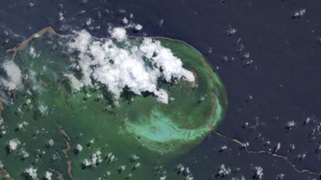
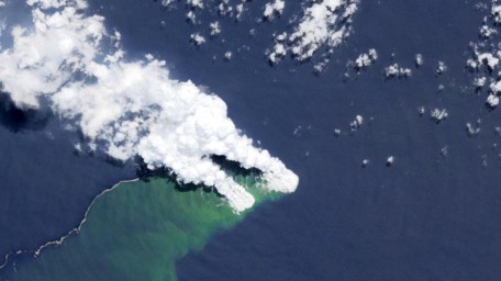
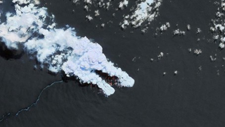
The German hyperspectral satellite EnMAP has captured a rare view of an underwater volcanic eruption in the Bismarck Sea off Papua New Guinea. Since 8 May, a plume of steam and gas has been visible in the affected area. The images acquired by the VNIR (visible and near-infrared) and SWIR (short-wave infrared) instruments reveal these plumes, as well as large masses of pumice floating to the surface. While low-level volcanic activity on the seabed is common in this region, it is unusual to observe an event of this magnitude, with plumes reaching altitudes of around 4,000 m.
EnMAP - VNIR (635 / 550 / 463 nm) / 24.05.2026
VNIR image (band combination red 635 nm, green 550 nm and blue 463 nm) emphasizes variations in water colour caused by fine suspended particles such as ash and volcanic dust, and floating pumice, all of which alter how the water reflects light, while also enhancing the contrast between volcanic material and the surrounding water column.
The SWIR image (band combination (red 2199 nm, green 1653 nm and blue 1047 nm) captures the large steam and gas plume rising above the surface, with certain volcanic gases showing characteristic absorption features in the shortwave infrared range.
Water is remarkably efficient at absorbing light, especially in the near-infrared and shortwave infrared ranges, which is why the ocean surface appears almost black in satellite imagery under normal conditions. This characteristic makes eruption-driven sediment plumes particularly easy to identify: pumice, ash, and volcanic particles pushed to the surface by hydrothermal forces reflect sunlight far more strongly than the clear water around them. The resulting brightness contrast allows the spatial extent and distribution of the plume to be mapped in considerable detail. Monitoring how the plume shifts and expands over time also provides meaningful insights into the strength and duration of the underlying eruption.
The images obtained using different EnMAP band combinations highlight complementary aspects of this event. The VNIR image (band combination red 635 nm, green 550 nm and blue 463 nm) emphasizes variations in water colour caused by fine suspended particles such as ash and volcanic dust, and floating pumice, all of which alter how the water reflects light, while also enhancing the contrast between volcanic material and the surrounding water column. The SWIR image (band combination (red 2199 nm, green 1653 nm and blue 1047 nm) captures the large steam and gas plume rising above the surface, with certain volcanic gases showing characteristic absorption features in the shortwave infrared range.
EnMAP has been in orbit since April 2022 and has acquired more than 215,000 images of Earth during this time. The satellite is equipped with two spectrometers operating in the VNIR (400–1000 nm) and SWIR (900–2450 nm) spectral ranges, providing 224 spectral bands for every image pixel. This detailed spectral information enables the identification of materials, gases, and environmental changes that are otherwise difficult to detect, helping researchers investigate complex natural phenomena such as volcanic eruptions and their environmental impacts.

