

Loading
Photogrammetry and Image Analysis Department
The Photogrammetry and Image Analysis Department develops operational image processors that derive geometric (photogrammetry) and semantic (image analysis) information from digital remote sensing images from satellites, aircraft, and UAVs. The increasing number of missions - including the Copernicus program and new satellite constellations - is driving the development of remote sensing technology. In addition, the rapid development of machine learning and increased computing power are accelerating this progress.
In order to provide standardized, high-quality data to the growing user community, the department focuses methodically and application-oriented on the automatic extraction of geoinformation from optical or multimodal data sets. The main areas of research are:
- Photogrammetry: Stereo processing and object detection
- Real-time methods for imagery from airborne sensors for traffic monitoring
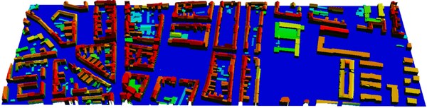
The photogrammetric work focuses on direct georeferencing using position and location data (physical approach, also calculated in real time on GPUs). This includes automatic control point search in image databases and the derivation of digital surface models (DSM) and terrain models (DTM) from optical stereo images using computer vision methods. To improve the level of detail, AI methods are used to enhance resolution - for optical as well as multispectral and hyperspectral data. With the help of AI methods, objects such as buildings and roads are segmented, modeled, and vectorized from the elevation models and image data, for example to derive building outlines, vegetation, or areas of transport infrastructure.
In order to make the geoinformation obtained directly usable for applications such as traffic monitoring, the department is also developing hardware and software systems for real-time processing of serial aerial images directly on-board aircraft. The system has been significantly enhanced in recent years and enables orthorectification, DSM creation, and mosaicing of image data, as well as the derivation of traffic-related parameters such as vehicle detection and speed measurement. It is also possible to analyze pedestrian movements and densities in large crowds. The support of autonomous driving systems through remote sensing is a new field of research at the institute, which is to be greatly expanded in the future.


Links
Contact
Dr. Stefan Auer
Head of Department
Remote Sensing Technology Institute
Photogrammetry and Image Analysis
Oberpfaffenhofen, 82234 Weßling