An estimated 1.6 million metric tons of munitions from the two world wars lie on the seabed of the North Sea and the Baltic Sea—off the German coast alone. If loaded onto a freight train, this amount would fill a train approximately 1,000 kilometers long—roughly the distance from Berlin to Paris. The casings of this abandoned ordnance are increasingly corroding, causing explosives to be released unchecked into the sea and absorbed by flora and fauna. This not only endangers marine ecology but can also pose risks to human health. In addition, the contaminated areas threaten the safety of shipping, impair fishing, and complicate the expansion and operation of offshore wind farms.
To address this growing threat to the environment, people, and the economy, the Federal Ministry for the Environment, Climate Action, Nature Conservation, and Nuclear Safety (BMUKN) has launched the Emergency Program for Munitions Contamination in the North Sea and Baltic Sea. At the latest with the start of the pilot recovery operation in Lübeck Bay in the summer of 2024, the issue of contaminated sites in the sea has come increasingly into focus.
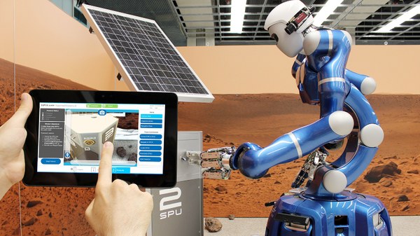
The DLR has also recognized the urgency of this problem: Through the WATERSIDE initiative, several DLR institutes are pooling their expertise and are confident that they can provide valuable support for the process of recovering munitions using existing methods from various fields of research. In this way, the DLR is applying its experience from space, transportation, security, and aviation to the pressing problem of abandoned munitions: Concepts that have primarily been used in space exploration—such as on the ISS—are now being tested and adapted for underwater use to safely grasp and recover old munitions without the need for divers. Modern technologies such as quantum sensing make it possible to detect munitions even beneath several meters of sediment and to reliably identify these dangerous contaminated sites.
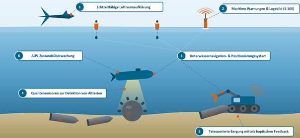
WATERSIDE Infographic
Overview of the WATERSIDE technology chain, from aerial reconnaissance to teleoperated recovery on the seafloor: (1) A drone performs real-time aerial reconnaissance and monitors the operational area from above. (2) Digital, standards-compliant navigation warnings are distributed to nearby traffic participants. (3) An underwater navigation and positioning system enables precise location and navigation underwater. (4) An autonomous underwater vehicle (AUV) equipped with innovative sensors detects buried munitions and other contaminants on the seafloor. (5) A remote-controlled system retrieves the found munitions using a gripper arm and assists the operator with haptic feedback. (6) Continuous AUV status monitoring ensures the reliable operation of the underwater systems throughout the entire mission.
The WATERSIDE project focuses on the following thematic areas:
Novel sensor technology for detecting contaminated sites: The goal is the precise location and identification of sunken munitions. To this end, novel sensor systems are being used, including innovative quantum sensors (see infographic, point 4). These can detect even the smallest magnetic and gravimetric anomalies, thereby locating even deeply buried objects. Subsequent classification allows for distinguishing between harmless objects and hazardous contaminated sites.
Situational Awareness and Navigation Alerts: During search and clearance operations, it is crucial to monitor nearby vessel traffic and identify hazards early on. To this end, the area being cleared is continuously monitored by an airborne drone to ensure that no unauthorized vessels enter the secured zone (see infographic, point 1). In addition, maritime stakeholders are informed via a new digital warning service based on the IHO S-100 standard. This service provides relevant information—such as details on ongoing salvage operations—precisely and in real time, both on board ships and on land, to inform nearby vessels of the salvage operation taking place (see infographic, point 2). AUV status monitoring also informs the operator about the operational status of the autonomous units, enabling early corrective action in the event of malfunctions (see infographic, point 6).
Teleoperated recovery and precise positioning: The actual recovery of the munitions is carried out using a specially developed, teleoperated gripper arm, which enables precise and safe operation even under difficult visibility conditions thanks to haptic feedback (see infographic, point 5). To control this gripper arm safely and accurately, precise underwater positioning is required—a particular technical challenge, as GPS-based navigation is not available. A specially developed decentralized underwater navigation and positioning system therefore handles the precise localization of the gripper arm and the autonomous underwater vehicles involved (see infographic, point 3).
The goal is to support industry, science, and government agencies with innovative and sustainable solutions, ranging from detection and identification to safe recovery. Therefore, the WATERSIDE project is being carried out in close coordination with partners from industry and government to adapt DLR’s proprietary systems as effectively as possible to the requirements in the field.