
GRIPS


Infrared spectroscopy of airglow in the near infrared using GRIPS
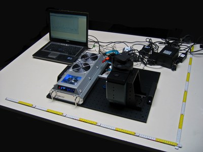
Since 2005 the German Remote Sensing Data Center (DLR-DFD) has operated the infrared spectrometer GRIPS (Ground-based Infrared P-branch Spectrometer) in order to monitor airglow in the mesopause region (80-100 km height) (Fig. 1). The origin of most airglow luminescence is a rather narrow layer of excited hydroxyl (OH) molecules from about 83-90 km height peaking at about 87 km.
The excitation is caused by the exothermic reaction of ozone (O3) and atomic hydrogen (H). Chemically excited OH molecules emit near-infrared radiation from several rotational-vibrational transitions. These emissions can be measured with high temporal resolution by the GRIPS instrument during nighttime. The rotational OH temperatures derived from the emission spectra are good proxies for the atmospheric kinetic temperatures at 87 km altitude.
Importance of airglow observations
The atmosphere exhibits nearly the same mixing ratio within this height regime as on the ground. However, the density is about five orders of magnitude lower. Therefore, this region responds very sensitively to minor changes in any atmospheric chemical or physical parameter. Furthermore, radiative cooling into space is very efficient at this height, in particular the 15 µm emission of CO2, which is the main cause for this cooling. Consequently, the global increase of CO2 in the atmosphere is expected to have a large impact on the temperature observed at this altitude. In contrast to the troposphere, however, decreasing temperatures are expected within the next decades. Therefore continuous assessment of mesopause temperatures constitutes a major aspect of climate change research.
But also on shorter time scales, the temperature of the mesopause region is characterized by complex dynamics, and especially atmospheric waves play a key role in this context. Their influence ranges from a few seconds to several weeks. They can be classified as follows:
- Infrasonic waves are waves with periods under five minutes and spatial scales of a few hundred meters to a couple of kilometers; their restoring force is caused by the pressure gradient,
- Atmospheric gravity waves have periods longer than five minutes and up to a few hours, with a spatial extent from a few to several hundreds of kilometers; their restoring force is the buoyancy force,
- Planetary waves have periods ranging from several days to a few weeks and exhibit spatial scales of several thousands of kilometers; the Coriolis force is their restoring force.
Instrumentation
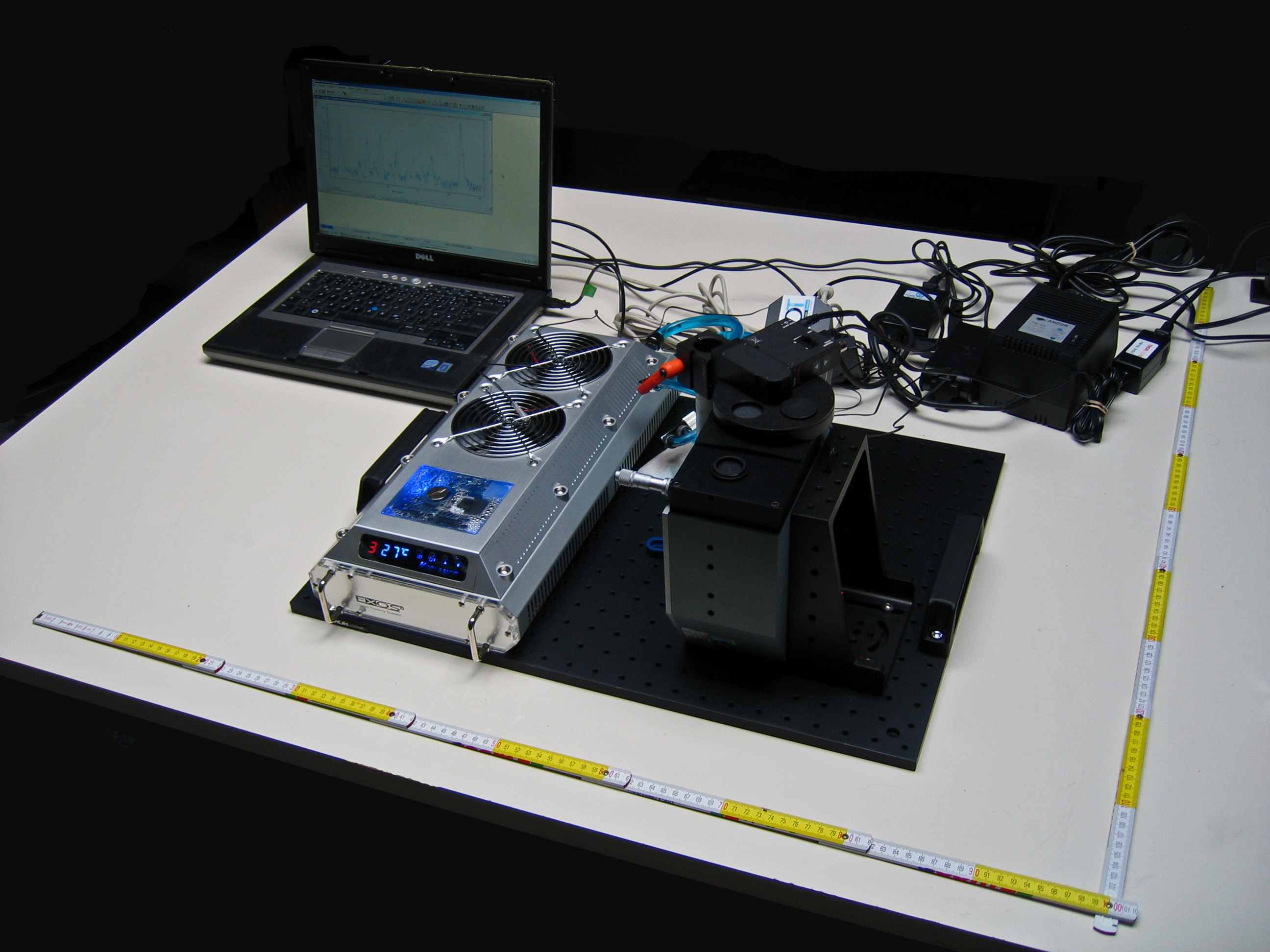
Measurements are derived using different grating spectrometers (GRIPS) covering the near infrared wavelength range. In the early years since 2003, DLR-DFD operated the instruments GRIPS 3 and GRIPS 4 (Fig. 2). They are based on a development at the University of Wuppertal in the 1980s, which is still operating the first two instruments of this type. GRIPS 3 and GRIPS 4 are equipped with highly sensitive germanium detectors cooled with liquid nitrogen down to -196°C for achieving the optimal signal-to-noise ratio. Using a moveable diffraction grating the OH emission from 1.52 to 1.55 µm is scanned within three minutes.
In 2008, DLR-DFD designed a completely new type of GRIPS instrument. It is presently one of the most advanced OH instruments equipped with an InGaAs photodiode detector array that is specifically utilized for the observation of bright OH airglow emissions between 1.5 and 1.6 µm. The high temporal resolution of only 15 (in special mode even 10) seconds per spectrum is significantly higher than the atmospheric Brunt-Väisälä frequency. This is notably better than the temporal resolution achieved by most scanning grating spectrometers, making it well suited for the study of short periodic atmospheric waves, such as gravity and even infrasonic waves. Furthermore, the precision of the instrument was also increased by one order of magnitude. All newly designed instruments are operated automatically and send their data on a routine basis to the World Data Center for Remote Sensing of the Atmosphere (WDC-RSAT), a service provided by DFD to support the data and communication platform of the Network for the Detection of Mesopause Change (NDMC – see link at right).
GRIPS measurement stations
After the first GRIPS instrument at the Environmental Research Station Schneefernerhaus (UFS) on the Zugspitze mountain (47.42°N, 10.98°E) was commissioned in 2005 (Fig. 2), DLR services in Oberpfaffenhofen (48.08°N, 11.27°E) became operational in January 2009 (Fig. 3). In addition, since November 2010 a GRIPS instrument has been operated during the winter seasons at the ALOMAR Observatory in northern Norway (69.28°N, 16.01°E).
Using the mobile GRIPS 4 instrument, a measurement campaign took place on board the German research vessel “Polarstern” from Bremerhaven to Cape Point, South Africa, on behalf of the European Space Agency (ESA) with the main objective to validate satellite-based temperature derived from ENVISAT-SCIAMACHY (see link at right).
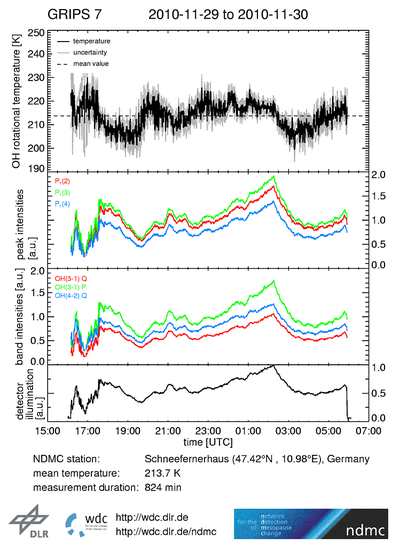
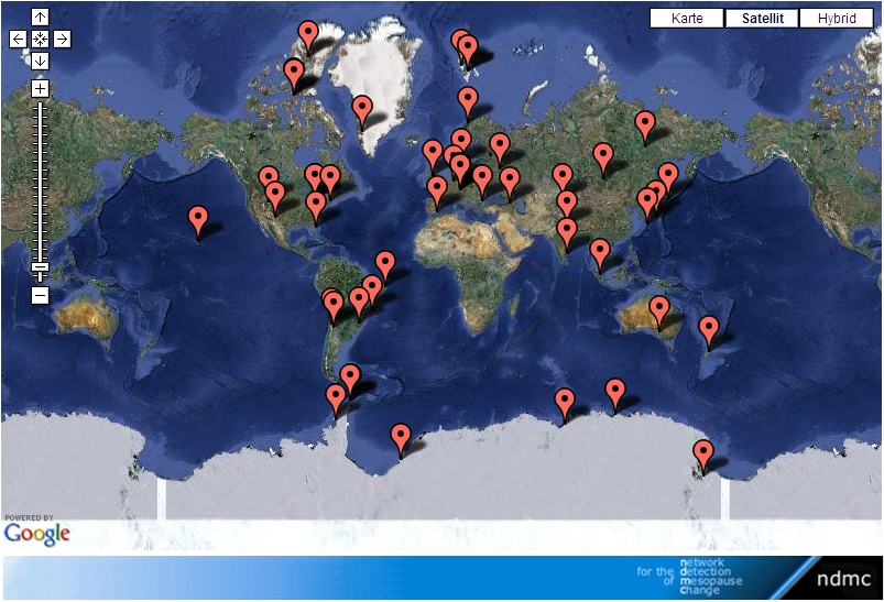
Each GRIPS measurement site is part of the international global NDMC network, a global program with the mission to promote international cooperation among research groups investigating the mesopause region (80-100 km) with the goal of early identification of changing climate signals. NDMC is currently composed of 50 high-quality, remote-sensing research stations for observing and understanding the physical and chemical state of the mesosphere, with initial emphasis on airglow observation in the mesopause (see Fig. 4 or the NDMC website at right). NDMC network operations officially started in 2007 based on a founding initiative of DLR-DFD. They are jointly coordinated by DLR-DFD and the Argentinean organization CONICET; coordination center is the Environmental Research Station Schneefernerhaus (UFS). NDMC is continuously evolving and plans new observing sites and facilities (e.g., in Europe or Africa) in the next years to obtain a well-balanced global coverage of its stations for adequately and reliably assessing global issues. It is also planned—and partly already realized—to extend the current focus of airglow measurements to other measurement techniques such as lidar, radar, satellites or modeling. This also includes an extension to cover the entire mesosphere. WDC-RSAT acts as the NDMC data center, provides the communication and information platform for NDMC, and also handles all aspects of data management and web hosting. Some of the measurements collected in NDMC, for example, the GRIPS measurements, are available at the NDMC website in near real time (Fig. 5 or NDMC link at right).
