Satellite images reveal what would otherwise remain hidden: on 4 September 2008, the German Aerospace Centre (DLR) will publish a picture book entitled "Global Change – Earth from Space". The book shows views of Earth that document the influence of humans on "their" planet and thus reflect, in a sense, the "fingerprint of humankind". Despite the seriousness of the subject matter, these images also show how beautiful and worth preserving the Blue Planet is.
With "Global Change – Earth from Space", the DLR is now publishing its third book in collaboration with the Frederking und Thaler publishing house (Munich); scientific topics are presented to the reader in a generally understandable manner.
Illustrated book: Global Change – Earth from Space
Cover image of the illustrated book "Global Change – Earth from Space" presented by the German Aerospace Centre (DLR). The book conveys extraordinary views of Earth that document the influence of humans on "their" planet.
For decades, satellites have been documenting how human activity is changing the Earth, even in remote regions. They provide information that remains invisible to the human eye, and the unprecedented images obtained from this data – original photos, specially calculated 3D images, vivid infographics and forecasts for the future – tell of the advance of deserts, the disappearance of forests and the incessant growth of megacities.
In generally understandable texts, the authors place the phenomena illustrated in the context of the discussion on global change and highlight which forward-looking solution models are conceivable. In addition, mountaineer Reinhold Messner, DLR Executive Board member Thomas Reiter and philosopher Peter Sloterdijk provide personal reflections on the topic. Thus, this book not only contains a unique assessment of the changes brought about by humans, but also a call to action.
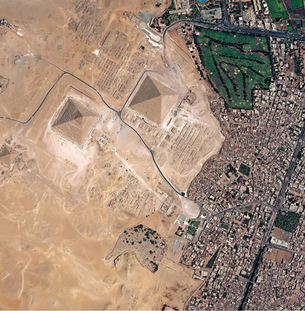
World Heritage Site and Megacity – Cairo, Giza
Built 4,500 years ago, the pyramids bear witness to a time when only a few hundred million people lived on Earth. Today, there are 6.6 billion, with 80 million more every year. The population explosion is reflected in the growth of cities.
For decades, satellites have been documenting how human activity is changing the Earth, even in remote regions. They provide information that remains invisible to the human eye, and the unprecedented images obtained from this – original photos, specially calculated 3D images, vivid infographics and forecasts for the future – tell of the advance of deserts, the disappearance of forests and the incessant growth of megacities.
In generally understandable texts, the authors place the illustrated phenomena in the context of the discussion on global change and point out which forward-looking solution models are conceivable. In addition, mountaineer Reinhold Messner, DLR board member Thomas Reiter and philosopher Peter Sloterdijk provide personal reflections on the topic. Thus, this book not only contains a unique inventory of the changes brought about by humans, but also a call to action.
Condensation trails from ships, west of Brittany
"Ship tracks" (condensation trails) appear on satellite images as elongated structures of low clouds over the sea, which are clearly not of natural origin. They are caused by emissions, particularly from large ships, and result from their high sulphur dioxide emissions.
Stefan Dech is Professor of Remote Sensing at the University of Würzburg and Director of the German Remote Sensing Data Centre (DFD) at the German Aerospace Centre (DLR). The unique images in this book were created under his leadership.
Rüdiger Glaser is Professor of Geography at the University of Freiburg and heads the Institute of Physical Geography; he is an expert in climate history and contributed the scientific texts to this book.
Robert Meisner headed the Marketing and Media Department at the DLR's DFD and is a specialist in scientific satellite data visualisation. In mid-2008, he moved to the European Space Agency (ESA).


