BAMFORESTS: Bamberg Benchmark Forest Dataset of Individual Tree Crowns in Very-High-Resolution UAV Images
BAMFORESTS: Bamberg Benchmark Forest Dataset of Individual Tree Crowns in Very-High-Resolution UAV Images
The accurate and automatic detection of individual trees is crucial for forestry, monitoring of biodiversity, and various other applications. Very high resolution RGB data from manned and unmanned aircrafts is well-suited for the delineation of individual tree crowns; however, the labeling process requires expert knowledge and is time consuming. Therefore, datasets with individually delineated tree crowns in very high resolution RGB data are costly. In cooperation with the University of Bamberg, we publish the BAMFORESTS dataset. BAMFORESTS contains 27,160 labelled trees in 105 hectares of three different AOIs in Bavarian forests and city parks and comes with a proposed dataset split to serve as a benchmark dataset. BAMFORESTS is one of the worldwide largest datasets of this kind.
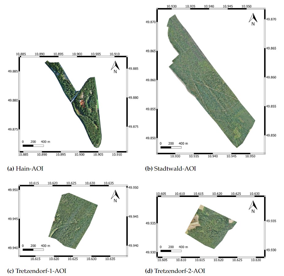
BAMFORESTS data come from four different AOIs, which are shown in Figure 1. All AOIs are located within a radius of 20 km in and around Bamberg, and the aerial surveys were carried out as part of the BaKIM-Project funded by the Bavarian Ministry for Digital Affairs. The BaKIM-Project is a cooperation of the City of Bamberg and the Cognitive Systems Group from the University of Bamberg.
Figure 1. Overview of all four AOIs in the BAMFORESTS benchmark dataset
Figure (a) shows the complete Hain-AOI, (b) shows the complete Stadtwald-AOI, (c) shows the complete Tretzendorf-1-AOI, and (d) shows the complete Tretzendorf-2-AOI. All images are scaled equally, allowing for comparison of the AOI sizes (EPSG:4326).
The images in the dataset are divided into the mentioned 57.14% Train-Set, 15.24% Val-Set, 14.29% Test-Set-1, and 13.33% Test-Set-2. Corresponding annotations are available in their respective .GeoJSON files. Test-Set-1 is based on the Hain plot, which is completely independent of the Train-Set and Val-Set. However, Test-Set-2 comes from the same forests as the Train-Set and Val-Set.
Based on the division of the hectare-plots, the orthomosaics and associated annotations are cropped, then divided and collectively converted into the COCO format. There is a 50 % overlap between the images both horizontally and vertically. To meet the needs of the various scenes and available GPU-VRAM, the BAMFORESTS dataset provides two different image sizes (1024x1024 pixels and 2048x2048 pixels). At the edges of the images, individual crowns are cropped. Figure 2 shows example images from the test set.
Figure 2. Image and annotations
from (a) the Hain plot of Test-Set-1, (b) the Stadtwald plot of Test-Set-2, (c) the Tretzendorf plot of Test-Set-2.


