
Team: New SAR Applications

Earth observation with SAR instruments opens up new applications fields extending well beyond simply interpreting imaged greyscale values from radar backscatter. SAR data contains, in a complex code, information about the precise location, movement, structure and electromagnetic characteristics of each reflecting object captured in the image. Since SAR instruments like those on the German radar satellites TerraSAR-X and TanDEM-X are active, coherently recording systems themselves supplying the required illumination and thus independent of the position of the sun or other external influences, recordings can be repeated under exactly the same conditions. Accordingly, even the smallest differences in the complex SAR data from two images can lead to direct conclusions about physical changes in signal dispersion, distance and reflection mechanisms.
Digital Elevation Models from TanDEM-X
The most common application for SAR data is interferometry used to analyse changes in distance, which are measured as fractions of radar wavelengths (determined by phase differences). This can involve either differential interferometry, in which, for example, the local ground uplift and subsidence that take place between several overflights become visible, or the production of elevation models, where differences in distance result from slightly different viewing angles (as with 3D reconstructions from stereo images). The TanDEM-X satellite mission, uses simultaneous recordings made by two radar satellites separated by a few hundred metres. The resulting small sub-millimetre scale radar pulse and phase differences in the reflection signals can be used to produce a highly precise “3D” model of the entire globe. Such a large area digital elevation model (DEM) requires a recording and processing procedure that extends over several years.
The New Applications team contributed to the interferometric processing chain for data from the TanDEM-X mission. In particular, new innovative methods were developed for height estimation and error correction. This makes possible absolute elevation precision down to a few metres and even centimetres worldwide. Because of these contributions, even before final calibration, highly precise elevation models are created that can be scientifically assessed. Whereas differential interferometry is interference-prone if there are major changes between images, the elevation differences from two temporally offset DEM recordings can be used to unambiguously measure even changes to Earth’s surface caused by glacier melting, deforestation and active volcanic lava fields. This capability has been extended to create novel, global DEM change maps for different recording times and make them available to the scientific community. Because of the team's processing expertise, changes in forestation, mines, glacier fields and ice caps on volcanos, for example, are being measured worldwide.
High-precision Earth measurement
In addition to interferometric analysis, SAR data also make possible applications that exploit the capability to precisely determine the location of objects. During the last few years ever more sophisticated methodologies have been developed at IMF to eliminate the sources of many kinds of errors when determining the precise location on Earth of SAR images. For this purpose weather models are also used to compensate for the influence of water vapour on radar signal propagation. This means that today products from our processing chains are accurate down to less than two cm for orbit distance and flight direction. If the orbit is precisely determined, then at any point on Earth a visible object can be localized with centimetre accuracy. Our geometric methods are now also used by ESA as "correction glasses" for its SAR satellites.
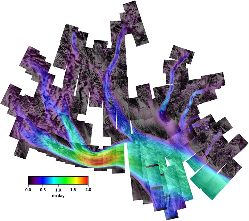
Glaciology
The height change and ground motion measurements are used by our team to record inaccessible glacier regions in the Antarctic and to measure ice field velocity from shifts in structures like glacier cracks. The image at right showing the flow velocity the glacier system on the Ross ice shelf in the Antarctic is an example. This kind of data provides important information on the climate-relevant dynamics of the mass balance of ice fields.
Our SAR methodologies are being continually refined in order to use them also for innovative earth observation missions. The team is integrating into existing processors the data from ESA’s Sentinel SAR satellites. By closely interlocking applications and research on new processing methods, we are actively involved in projects like monitoring earthquakes, volcanos, and the stability of railway tracks and other Infrastructure.