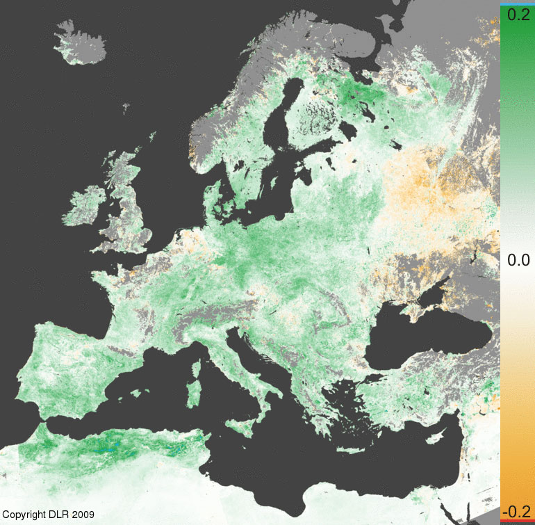
NDVI anomaly over central Europe reveals unusual warm beginning of spring 2009

The Normalized Difference Vegetation Index (NDVI) is a measure of the greenness of vegetation. Data from the Advanced Very High Resolution Radiometer (AVHRR) sensor on board of the NOAA weather satellites are received and processed at DLR-DFD on a daily time scale since the beginning of the 1990. DLR-DFD uses these data to derive the NDVI as daily, weekly, 10-days (decadal) and monthly composites.
Calculating the mean NDVI for the decadal composites of each month a reference NDVI composite can be derived which can be regarded as the mean greenness of the vegetation. Subtracting the actual decadal composite and the reference decadal composite opens a view on the growth characteristics in comparison to the long term mean (anomaly).
The NDVI anomaly for the time span from May 1st to May 10th, 2009, over central Europe reveals an unusual warm and rainy beginning of May, indicated by an increase of the actual decadal NDVI of up to 0.2 NDVI value. In northern Spain and the eastern part of Europe (Belarus, Ukraine) the vegetation is not as far developed as in the past 15 years due to the cold temperatures, while in northern Africa and the Mediterranean warm and sunny weather has stimulated vegetation growth.
The anomaly map of the NDVI mirrors the specific weather situation over Europe and northern Africa during the first decade of May 2009. It is interesting to note that the Iberian Peninsula and part of northern Africa (Morocco, Tunisia and Algeria) got more precipitation compared to the long term mean in late winter and early spring. In central Europe the winter time with cold weather ended abruptly at the end of March with the beginning of a very sunny and warm spring.
Dark green pixels in the anomaly map represent an increase of the actual 10-day composite of 0.2 compared to the long term mean, while dark orange pixels mark a decrease of -0.2. White pixels indicate no difference compared to the long term mean and the actual 10-day composite. Light blue pixels indicate an increase of more than 0.2. Water is light gray and no data (clouds or snow) are indicated by dark gray color.
The images can be viewed in more detail at the WDC Website.
