
Digital seeing aid for Sentinel-1 satellites
EOC researchers have developed for ESA a correction procedure for the radar satellites of the European Sentinel-1 mission. With this methodology the geographic location of satellite measurements can be determined with significantly more accuracy. Every pixel can be localized on the ground with a precision of a few centimetres instead of a few metres.
Satellite-borne SAR (Synthetic Aperture Radar) uses radar impulses transmitted to Earth’s surface in order to supply recordings unconstrained by time of day or the weather situation. The SAR principle is used to analyse the transit time of these signals, and in addition to the recordings provides highly precise measurements of the distance from the satellite to the ground. The position measurement functions for any object that is visible as an pixel in the radar image. If all the influences that interfere with the measurement are factored out, positional accuracy of up to one hundredth of the image resolution can be achieved. Thus the location of an image pixel with a ground resolution of one metre can be determined down to a centimetre.
The complex correction procedure was first developed at EOC in the course of the German TerraSAR-X radar mission. Now the Sentinel-1 user community is also to profit from this DLR expertise. Accordingly, ESA has commissioned EOC to improve the geometric measuring accuracy of the Sentinel-1 image data from the present several metres down to at least 20 centimetres.
After more than two years of development and testing, the correction-processor was delivered to ESA in May 2021 and in June introduced at the ESA FRINGE 2021 conference. At present the processor and the resulting product are in trial operation at ESA. First trial applications in the areas of ice mapping and interferometry are already yielding promising results. ESA plans to have further user studies by the end of 2021.

With the European Sentinel-1 Copernicus Mission the S-1 ETAD (Sentinel-1 Extended Timing Annotation Dataset) correction methodology can be employed for the first time operationally. It will be used to map the earth globally and to improve many applications, for example measuring large-scale ice movement or mapping ground displacement. Since the launch of the first Sentinel-1 satellite in 2014 and the second satellite in 2016, the Sentinel-1 Mission has revolutionized radar Earth observation. Every day, the two satellites Sentinel-1A and Sentinel-1B supply over 100 radar images of Earth’s surface that are available free of charge to all users.
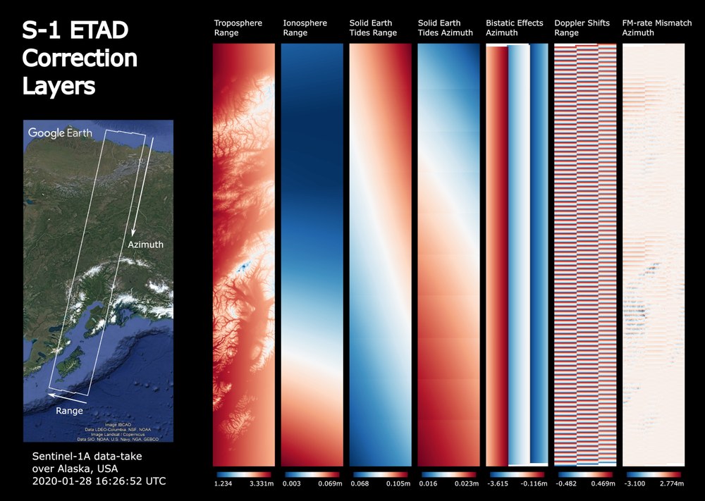
Because of the massive amount of data, the processor developed by EOC has to run very rapidly. The complex corrections for a typical Sentinel-1 recording are computed in just a few minutes. In the process, the software for each individual recording takes into account the signal propagation delays through the neutral troposphere and the dispersive ionosphere, the distortion of the solid earth cause by tidal forcing, and SAR-specific image errors that arise during operational processing of the Sentinel-1 images. This demanding analysis is made using the exact parameters of each SAR recording, the satellite orbit determined to five centimetres, and a global terrain model with 90 m resolution. In addition, there are the parameters of the numeric weather model of the European Centre for Medium-Range Weather Forecasts (ECMWF) and the electron content of the ionosphere as measured by the global satellite navigation systems (GPS, Galileo, GLONASS, …). These data sets are continuously downloaded by ESA’s Sentinel-1 ground segment and provided for the period of recording. The calculated effects add up to as much as 5 m in the range direction (image coordinates perpendicular to the satellite’s direction of flight) and up to 6 m in the azimuth direction (image coordinates along the satellite’s direction of flight). The results are made available as customized corrections for each Sentinel-1 radar image.
Final, operational generation by the Sentinel-1 ground segment and delivery of ETAD products is planned for 2022.