Global Sentinel-1 flood service for Copernicus launched
November 12, 2021
Global Sentinel-1 flood service for Copernicus launched
The service for mapping flooded areas is based on data from the European Sentinel-1A and Sentinel-1B satellites. With their "C-band" radar instrument, the satellites provide seamless images of the Earth's surface with a high return rate and a resolution of up to 5 metres, regardless of brightness and cloud cover. The interferometric wide (IW) swath amplitude data is used, which is recorded with a swath width of 250 kilometres.
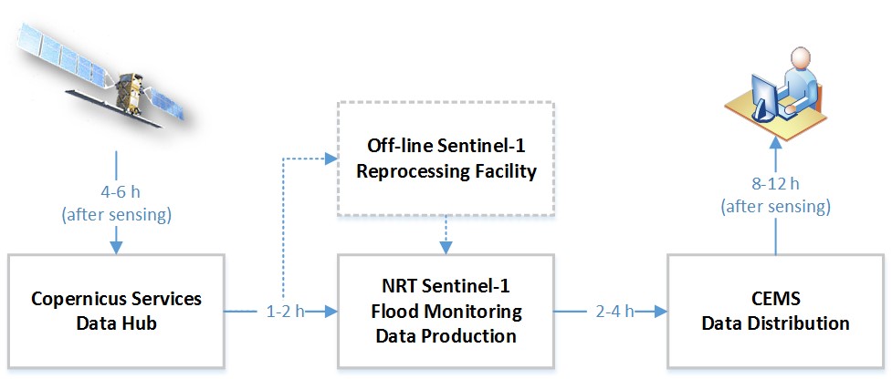
Over a thousand scenes are analysed automatically every day. The analysis is initially carried out independently by the respective flood algorithms of the EOC, the Vienna University of Technology and the Luxembourg Institute of Science and Technology (LIST). The results are then combined in an ensemble approach to maximise the classification quality. In addition, further global products such as reference water masks, classification uncertainties, exclusion masks and information on the affected population and land cover are created and made available via the Global Flood Awareness System (GloFAS) of the Copernicus Emergency Management Service (CEMS). The products are available there just a few hours after being recorded by the satellite.
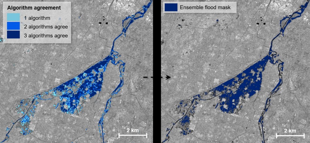
Combination of the individual results of the algorithms
from DLR, TU Vienna and LIST into a final flood product (China, 14 October 2021).
the implementation of the flood algorithm on the infrastructure of the Expert Flood Monitoring Alliance
the generation of a global seasonal and permanent reference water mask based on a Sentinel-1 time series analysis
the development of a global exclusion mask
Implementation of the ensemble approach to combine the individual flood results, taking uncertainties into account.
The development of the system was commissioned by the Joint Research Centres (JRC) of the European Commission and developed as part of the Global Flood Monitoring (GFM) project by the Expert Flood Monitoring Alliance, consisting of EODC Water Resources Monitoring GmbH, the German Aerospace Center (DLR), the Luxembourg Institute of Science and Technology (LIST), the Vienna University of Technology (TU Vienna), the CIMA Research Foundation and GeoVille.


