
High above low in the troposphere: Chaos in the stratosphere
A thaw in the south, heavy snowfall in the low mountain ranges, a sudden cold spell in northern Germany, not to mention dust from the Sahara. Chaotic conditions also prevail in the stratosphere. An unstable airstream at altitudes of 20-50 kilometres often gives rise to extreme weather conditions also at ground level.
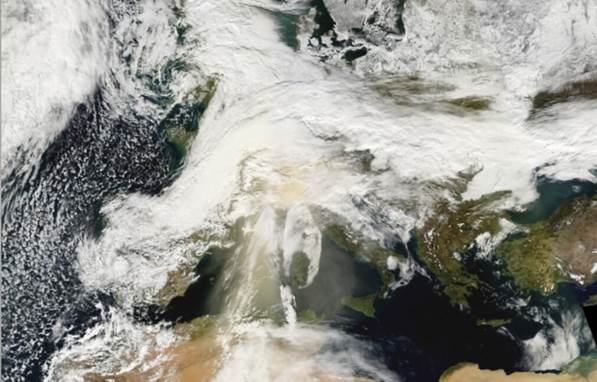
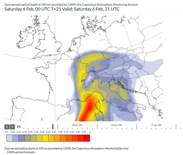
This year there has already been an unusual snowfall in Madrid and the storm “Goran”. After a long cold phase in the Alps there is now a sudden thaw with the risk of floods in the Alpine foothills. At the same time there was a cold snap on the north German coast and especially heavy snowfall in Germany’s lower mountain ranges. Then last Saturday a strong Sahara dust storm turned the snow on the western Alps red (see Figs. 1 and 2). At the Schneefernerhaus Environmental Research Station on Mount Zugspitze this event of February 6 was distinctly reflected by the particulate matter measurement (PM10). But also in Stuttgart and Munich the heavens turned greenish-yellow. Over Augsburg alone, every hour about 75 tons of desert dust were transported in a narrow vertical range of only 100 metres at five kilometres altitude.


Polare_Wellen
Your consent to the storage of data ('cookies') is required for the playback of this video on Quickchannel.com. You can view and change your current data storage settings at any time under privacy.
The mid-latitude change in our weather is caused by planetary waves, which are responsible for the regular succession of high- and low-pressure zones. The wave structure is clearly revealed in the animation.
Normally, a vortex forms over all of the cold north pole region in winter. At the edge of this vortex there are especially strong westerly wind streams extending from the troposphere (at about 5 km) up to the stratosphere (up to 50 km). This wind almost entirely prevents the exchange of air masses between the warm equator and the cold pole. If this band of wind is stable, then rather moist air of relatively mild temperature flows from the Atlantic over Europe.
Planetary waves are now disturbing this vortex, which leads to an energy exchange between the equator and the pole. The animation shows how the band of wind is deflected toward north and south, meandering because of the influence of the waves. This is associated with the transport of air masses. The stronger the band of wind is modulated, the easier especially cold or warm air masses can extend to mid-latitudes. In winter, planetary waves can expand into very high altitudes and influence the circulation of the stratosphere (10-50 km altitude). At present, wave activity is very high in both the troposphere and the stratosphere. The atmosphere is accordingly less stable than usual. The sequence of high- and low-pressure areas is more pronounced, and cold polar air masses can advance far toward the south where they encounter relatively warm air masses, as can be observed in Germany. On the weekend we observed a well-developed low-pressure area over Spain that diverted air masses from the Sahara to Germany. At the same time there was a high-pressure zone northwest of Norway that brought cold polar air from the north down to northern Germany. So there was a high-pressure area over a low-pressure area, a so-called “high-over-low” weather situation. This is known to cause episodes of extreme weather.
Extreme weather situations as well as occurrences of Sahara dust occur repeatedly. An especially interesting question is whether the formation of such weather situations will be more frequent in the future because of climate change. That cannot be judged on the basis of single events. For that reason, EOC scientists monitor the activity of planetary waves long term, also with the goal of assessing possible consequences for weather patterns.