From research to application: earth observation workshop on urbanisation in Africa
March 25, 2021
From research to application: earth observation workshop on urbanisation in Africa
Nowhere in the world are higher rates of urbanisation expected than in Africa over the next few decades. Population growth and rural exodus put urban space in short supply and make housing expensive. Informal settlements are the result. EOC researchers and representatives from the science community, public and administrative authorities, and non-government organisations discussed how artificial intelligence and earth observation can help address the impending challenges.
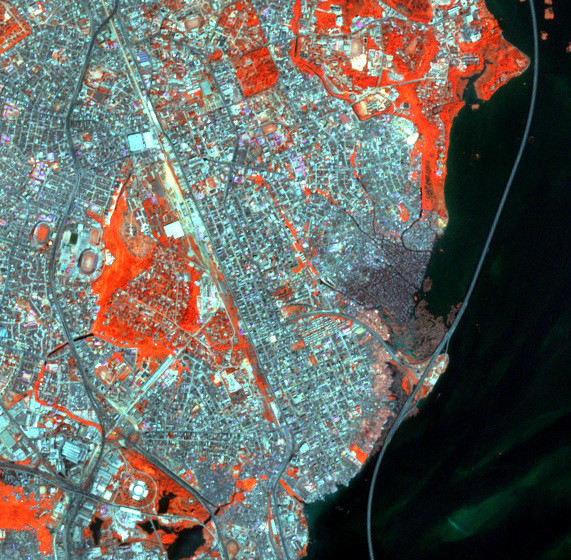
This Sentinel-2 image shows part of the Nigerian megacity Lagos
and the informal settlement Makoko, often variously described as a water slum or "Africa’s Venice" because of its pile dwellings.
So far, cities and informal settlements grow faster than they can be mapped. This information gap is to be closed with the help of the earth observation satellites of the European Copernicus programme. For that reason, EOC is participating in the “Framework Partnership Agreement on Copernicus User Uptake” (FPCUP). In this three-year project financed by the European Commission methods will be developed and tested together with users to map, characterise, and monitor the dynamics of urban growth and the formation of unregulated settlements, also with artificial intelligence methodologies. The information obtained is intended to support efforts to achieve sustainable urban development. The Copernicus Sentinel-2 satellite continuously supplies free of charge the required consistent, high-resolution optical satellite data for large areas.
Together with representatives from the potential user community of scientists, public and administrative authorities, and non-government organisations, the information products required for the urban-development and urban-geography analysis of African cities were determined in a recent online workshop. On the basis of this survey, applications concepts will be developed over the next few months and evaluated using applications scenarios.


