
Etna volcano eruption leaves thousands of tourists stranded
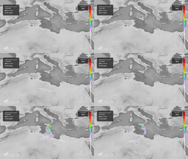
On the evening of Thursday, 6 August 2026, Mount Etna in Sicily entered its most intense eruptive episode of this year so far – a violent lava fountain from the Voragine crater that evolved into an effusive lateral eruption is still ongoing as of mid-August. One day after the eruption, the European satellite Sentinel-5 Precursor (S5P) detected the massive volcanic sulfur dioxide (SO₂) cloud south of Sicily for the first time. Since then, operationally processed S5P measurements at the Earth Observation Center (EOC) have continuously recorded the development of the volcanic emissions, tracking it as it drifted across the Mediterranean towards North Africa.
Etna volcano eruption leaves thousands of tourists stranded
Your consent to the storage of data ('cookies') is required for the playback of this video on Quickchannel.com. You can view and change your current data storage settings at any time under privacy.
Etna is Europe’s tallest and one of the world’s most active volcanoes. An effusive eruption in the Valle del Bove that began on 1 January 2026 was followed by successive paroxysms at the Voragine and Northeast Craters in late June, early July and again from 30 July. The current episode started on the evening of 6 August with a violent lava fountain from the Voragine crater that peaked around 04:00 local time on 7 August before shifting into an effusive lateral eruption with new vents opening on the volcano’s eastern flank.
Ash and gas have repeatedly risen several kilometers above the summit forcing the closing of the Catania Airport. The ash and gas cloud drifted southward and was tracked as far as the Libyan coast on 12 August. The Aviation Colour Code for the area around Etna was raised to Orange/Red due to extensive ashfall across eastern Sicily.
TROPOMI aboard S5P provided the first measurements of the SO₂ cloud over Sicily on 7 August and provides near-real-time measurements of the SO2 cloud throughout the eruptive sequence. The animation illustrates the dispersion of the SO₂ cloud in the days following the eruption, as measured by TROPOMI. The UVN spectrometer has a spatial resolution of 3.5 × 5.5 kilometers and provides daily global measurements of trace gases in the atmosphere, including SO₂, ozone, and nitrogen dioxide.
Approximately 7,000 tons of SO₂ were released during the eruption. The altitude of the SO₂ cloud was also determined using a scientific algorithm based on machine learning. The development of high-quality products and the visualization of sulfur dioxide emissions are part of the DLR project "INPULS."
SO₂ is a naturally occurring trace gas in the Earth’s atmosphere. The largest source of atmospheric SO₂ is the combustion of fossil fuels in power plants and other industrial facilities. Additionally, SO₂ is released by volcanoes into the lower troposphere (via passive degassing) and into the stratosphere (through explosive eruptions).
This corrosive gas poses a threat not only to the environment and populations near volcanoes but also to the occupants of aircraft if it infiltrates the cabin. It can also damage aircraft engines. The timely detection of SO₂ helps mitigate these risks and indicates areas where hazardous concentrations of gas and ash are to be expected.