
AI Forecasts and Simulates Air Pollution with EOC Satellite Data
Air pollution is one of the world‘s largest threats to health. Air quality control measures not only protect people and the environment; they also have economic advantages. A system developed with EOC participation now provides decision makers involved in transport, urban and environmental planning in the pilot regions of Stuttgart and North Rhine-Westphalia (NRW) with an information basis for the well-directed planning of counteracting measures.
The SAUBER project, a satellite-based system to display, forecast and simulate air pollution for the purpose of sustainable urban and regional development, combines satellite data, local measurements and environmental data with AI analytic methodologies to forecast for users pollution hazards both for specific locations and large areas.
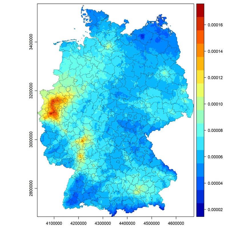
Satellite data from the Copernicus space programme provides information about land cover (Sentinel-2) as well as the wide-scale concentrations of air pollutants like nitrogen dioxide, particulate matter, ozone, and carbon monoxide (Sentinel-5P). These data make it possible to extrapolate to wider expanses the precise and continuously supplied but only point measurements from air quality measurement stations. Environmental data like land cover, settlement patterns, topography, weather, and emission sources (traffic data) make it possible to predict how pollutants are transported, diluted, modified, or break down. For the SAUBER project, various air pollutants were processed at EOC using Germany-wide Sentinel-5/TROPOMI data. EOC is also contributing to a land cover classification for all of Germany based on three years of Sentinel-2 images as well as on other wide coverage environmental and weather data.

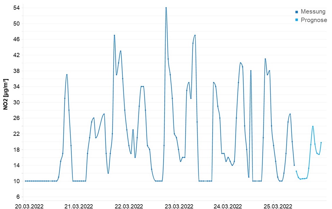
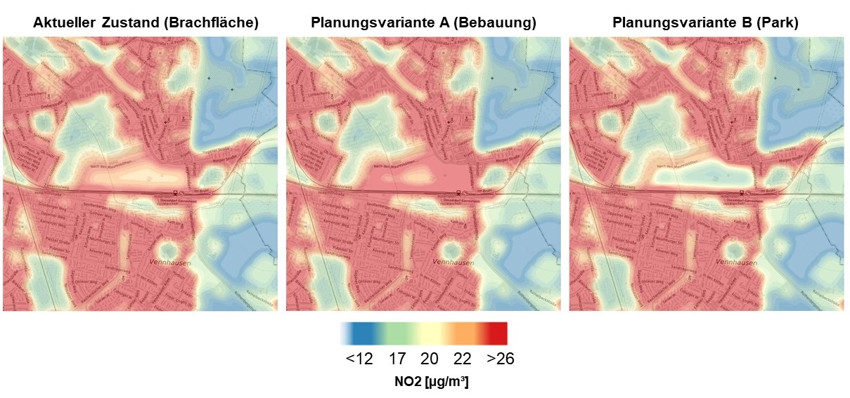
All data are automatically imported into an open-source geodata infrastructure (GDI), stored, and published via accessible and standardised geodata interfaces (OGC, the Open Geospatial Consortium). Then, the services developed in SAUBER access this database to display and forecast at high temporal resolution the pollutant concentration situation. With this approach, air and climate forecasts become possible for the following two days. Not only current measurements are used, but also weather, traffic, structural, historical, and many other types of data. Neural networks developed in the SAUBER project are trained with this data mix. Thus, the system can not only calculate how air quality evolves but also displays how changes in landscapes and settlement patterns affect the air pollution risk. This equips local authorities to initiate suitable measures to improve air quality and assess their effectiveness.


SAUBER was launched in autumn of 2018 and came to a successful conclusion at the end of 2021. The consortium was led by Software AG. The other research partners were geomer GmbH and its subcontractor the start-up company meggsimum from the Rhein-Neckar metropolitan region, the German Aerospace Center DLR, the Fraunhofer Heinrich Hertz-Institute, the Institute for Information Systems at Hof University, and the Leibniz Institute of Ecological Urban and Rural Development. The project was financed in line with the mFUND sponsorship guidelines of the Federal Ministry of Transport and Digital Infrastructure (BMDV) with a total of EUR 2,827,317. In the framework of these guidelines, since 2016 BMDV has sponsored research and development activities relating to data-based digital innovations for Mobilität 4.0. The project sponsorship was complemented by the active, specialist networking of representatives of the public policy, economic, public administration and research sectors and by the provision of unrestricted data on the mCLOUD portal.