Analysis of traffic-caused pollutant emissions using EOC satellite data
May 11, 2022
Analysis of traffic-caused pollutant emissions using EOC satellite data
NO2 emissions
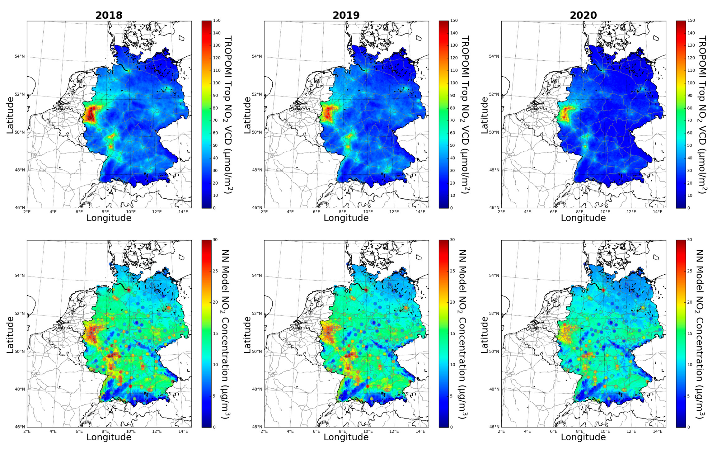
(Above) tropospheric NO2 column densities from Sentinel-5P data for 2018-2020 (annual mean) and (below) derived ground-level NO2 concentrations with in-situ NO2 observations (coloured circles). The reduction of NO2 emissions during the Corona lockdown is evident in the two maps for 2020.
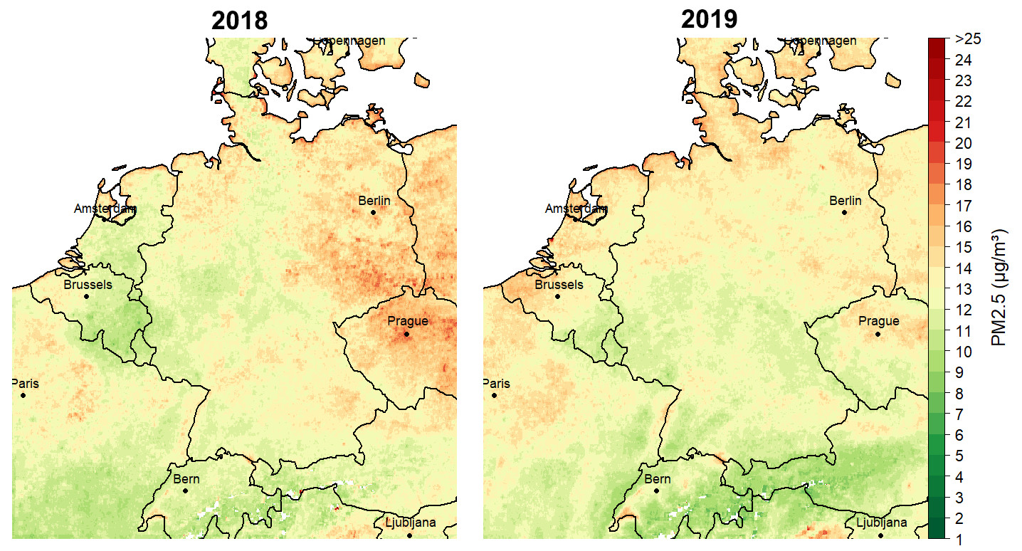
Maps showing PM2.5 concentrations based on Sentinel-3/SLSTR and Aqua/MODIS satellite data as the annual mean for 2018 and 2019. In general a clear relationship can be established between increased loads of particulate matter and agricultural areas.
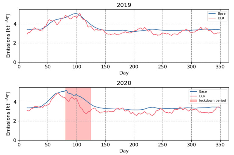
as derived in the S-VELD project (red line) and as they were entered a priori (blue line). During the COVID lockdown, which is marked in red for the year 2020, there is a much stronger drop in emissions than during the same period in 2019. The mean reduction in NO2 emissions during the Corona lockdown in 2020 was 19% (Source: TNO)
Traffic emissions endanger our health. Especially at heavy traffic locations, nitrogen dioxide (NO2) and particulate matter limits are often exceeded. EOC researchers and partners have therefore derived from satellite data ground concentrations of these air pollutants in the S-VELD project and analysed their sources and temporal distribution.
Together with national and international partner organisations, air pollutant emissions were derived from satellite observations for all of Germany and in greater detail for two regions in northern and southern Germany (Hanover-Braunschweig and Augsburg-Munich). This yielded better understanding of traffic-caused pollutant emissions and their contribution to German environmental pollution.
The air quality of the atmosphere can be investigated and monitored at high resolution globally with Europe’s Copernicus satellites. Initially, tropospheric NO2 and aerosol data were obtained at EOC from Sentinel-3 and Sentinel-5P measurements. These were used to derive high-resolution maps and data products showing ground-level NO2 and particulate matter concentrations that were made available to users via the EOC Geoservice.
The Sentinel satellite data were then combined with pollution dispersal models in order to analyse the spatial and temporal distribution of traffic emission loads. In addition, in order to improve the derivation of ground-level nitrogen oxide emissions from satellite measurements the NO2 satellite measurements were systematically related to information on known emission sources. The results thus included corrected NO2 emissions derived for Germany and the detail regions based on Sentinel-5P observations.
With the help of so-called pollutant labelling, as a final step the contributions to air pollution of the most important NO2 sources were determined. In urban agglomerations like the Ruhr and in large cities like Munich and Berlin, traffic is clearly the dominant source of nitrogen oxide, for example. Industrial emissions could be identified as a second important contributing source especially in the Ruhr and in Brandenburg.
The S-VELD project was financed by the Federal Ministry of Transport and Digital Infrastructure to the extent of some €1.9 million within the framework of the mFUND sponsorship guidelines over the period from August 2018 to January 2022. DLR, the consortium head, was responsible for deriving ground level pollutants and small scale emissions based on satellite data. The IVU Umwelt GmbH company of Freiburg contributed to the project its expertise in the field of traffic emission modelling. TNO (Utrecht, Netherlands) and the Freie Universität Berlin developed innovative methodologies for deriving and analysing anthropogenic emissions in Germany.
In a virtual final presentation the most important results of the S-VELD project were presented and the provision of Sentinel satellite data via EOC’s Geoservice was demonstrated. The project shows how Europe’s Sentinel satellites can provide important information for assessing air pollutants, their sources, and their spatial distribution in Germany and Europe, and the suitability of such analyses for environmental monitoring and decision support for public authorities.
Through the sponsorship programm mFUND, BMDV has supported research and development projects associated with data-based digital innovations for Mobility 4.0 since 2016. Project support was complemented by active networking among public, private and science experts and by the provision of unrestricted data on the mCLOUD portal.


