Skip to main content
Skip to navigation
Skip to footer
DLR Portal
Press
Accessibility
de
en
Earth Observation Center
About us
About us
▾
Earth Observation Center
▾
EOC Blogs
▾
German Remote Sensing Data Center
▾
Atmosphere
▾
Land Surface Dynamics
▾
Geo-Risks and Civil Security
▾
Information Technology
▾
International Ground Segment
▾
National Ground Segment
▾
Science Communication and Visualization
▾
Remote Sensing Technology Institute
▾
Atmospheric Processors
▾
EO Data Science
▾
Imaging Spectroscopy
▾
Photogrammetry and Image Analysis
▾
SAR Signal Processing
▾
Locations & Getting there
▾
Oberpfaffenhofen
▾
Weilheim
▾
Neustrelitz
▾
Bremen
▾
Berlin-Adlershof
▾
Awards
▾
Quality Management
▾
Appointment as a member of the International Ozone Commission
▾
Two new DLR Senior Scientists at EOC
▾
Helmut Rott Prize
▾
DLR Science Award 2022
▾
IEEE GRSS David Landgrebe Award
▾
The DLR Wildlife Rescuer: High-tech for animal welfare
▾
Other Awards
Research & Transfer
Research & Transfer
▾
Expertise
▾
Data Management and Data Access
▾
Data Processors
▾
Image processing
▾
Spectrometry
▾
Modeling and retrieval
▾
Topics
▾
Satellite Data
▾
Missions
▾
Daily weather images
▾
Copernicus: The European earth observation programme
▾
Projects & Missions
▾
Projects: Coastal Waters
▾
Projects: Atmosphere
▾
Projects: Geo-Risks and Civil Security
▾
Projects: Data Science
▾
Projects: Land Surface
▾
Completed Projects
▾
DESIS
▾
EO4CAM
▾
Global Urban Footprint (GUF)
▾
TIMELINE
▾
Research infrastructure
▾
German Antarctic Receiving Station GARS O’Higgins
▾
DEMMIN
▾
Services
▾
ZKI - Center for satellite-based Crisis Information
▾
WDC-RSAT - The World Data Center for Remote Sensing of the Atmosphere (out of service)
▾
EOWEB® GeoPortal (EGP)
▾
EOC Geoservice
▾
Latest Time Series: Fire
▾
OpAiRS
▾
Innovation & Transfer
▾
Spin-offs
▾
Wildlife finder
▾
ajuma UV-BODYGUARD
Latest
Latest
▾
News
▾
EOC News sorted by year
▾
Events
▾
Exhibitions
Multimedia
Multimedia
▾
Videos
▾
Media Library: Films
▾
Media Library: Traffic
▾
Media Library: Missions
▾
Media Library: Data
▾
Media Library: Time Series
▾
Media Library: Others
▾
Videos for EOC website
▾
Images
▾
DESIS images
▾
GARS image gallery
▾
Global Urban Footprint Gallery
▾
EOC Media Coverage
Careers & Education
Careers & Education
▾
Jobs at the EOC
▾
Information for students
>
Multimedia
>
Images
>
>
Global Urban Footprint Gallery
>
Europe
Home
>
Multimedia
>
Images
>
Global Urban Footprint Gallery
>
Europe
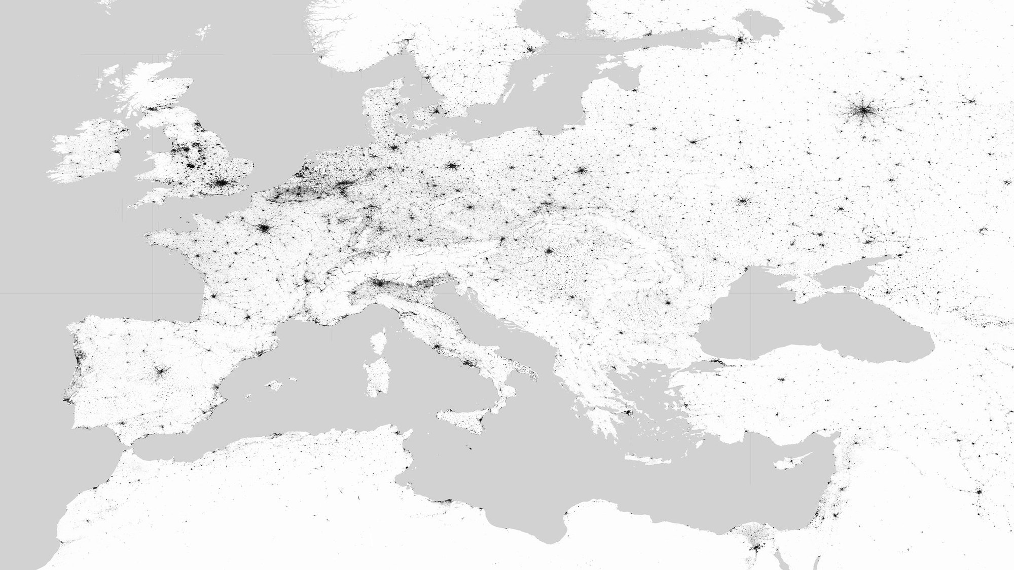
Europe
Europe
Scientists at the Remote Sensing Technology Institute (IMF) used the data acquired by the radar satellites TerraSAR-X and TanDEM-X to create maps of the urban structures.
Credit:
DLR
Download
Download