With the project "DatKI4BKG - Establishment of a data management system (DMS) and development of AI-based methods in remote sensing for BKG application areas", BKG and DLR are setting up remote sensing data systems for large amounts of data for the BKG and transferring AI applications from research to administrative practice. The project started in October 2021 and will run until April 2024.
In this context, DLR is primarily working on two topics:
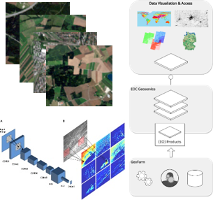
the design and development of a data management system (DMS) for remote sensing data in the form of data cubes and
the development and application of AI-based methods with a focus on supporting the creation of the land cover model (LBM-DE).
DatKI4BKG
In the "AI-based analysis in remote sensing" project, the BKG is working on the transfer of artificial intelligence (AI) applications in the field of remote sensing from research to applied practice so that this methodologically innovative approach can be used for specific administrative tasks. DLR is supporting the BKG in the DatKI4BKG development project, which is anchored within the framework agreement "IF-Bund - Innovative Remote Sensing for the Federal Administration".
In the land cover model, landscape changes are recorded and documented by evaluating multispectral satellite images. In the federal administration, the LBM-DE is used, for example, by the Federal Environment Agency or the Federal Institute of Hydrology to continuously record environmental changes. The LBM-DE also plays a key role in spatial planning, land development, land statistics and research into nature and the environment.
The sub-projects are coordinated within DLR to ensure that the components interact as smoothly as possible. This also includes measures aimed at transferring knowledge to the BKG and thus facilitating a close, active exchange between the BKG and DLR, for example through work shadowing.
Contact
Dr. Monika Gähler
German Remote Sensing Data Center
Geo-Risks and Civil Security
Oberpfaffenhofen, 82234 Weßling
Center for Satellite Based Crisis Information (ZKI)
zki(at)dlr.de
German Remote Sensing Data Center, Geo-Risks and Civil Security
Tel: +49 173 5343453; Available daily from 8:00 to 20:00


